
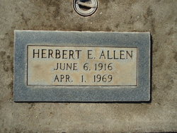
Herbert Ethan Allen
| Birth | : | 6 Jun 1916 |
| Death | : | 1 Apr 1969 San Mateo County, California, USA |
| Burial | : | John Clevenger Cemetery, Crystal Lakes, Ray County, USA |
| Coordinate | : | 39.3551300, -94.1540600 |
| Plot | : | Sec 33 Lot 1710 sp 1 |
| Description | : | Birth and death dates and locations, mother's maiden name Althouse, from California Death Index Records. 52-year-old Herbert Ethan Allen was interred, per the Chico Cemetery Association Records, in the plot noted, on April 4, 1969. |
frequently asked questions (FAQ):
-
Where is Herbert Ethan Allen's memorial?
Herbert Ethan Allen's memorial is located at: John Clevenger Cemetery, Crystal Lakes, Ray County, USA.
-
When did Herbert Ethan Allen death?
Herbert Ethan Allen death on 1 Apr 1969 in San Mateo County, California, USA
-
Where are the coordinates of the Herbert Ethan Allen's memorial?
Latitude: 39.3551300
Longitude: -94.1540600
Family Members:
Parent
Siblings
Flowers:


Nearby Cemetories:
1. John Clevenger Cemetery
Crystal Lakes, Ray County, USA
Coordinate: 39.3551300, -94.1540600
2. John Cleavenger Cemetery
Crystal Lakes, Ray County, USA
Coordinate: 39.3551407, -94.1542053
3. Clevenger Cemetery
Crystal Lakes, Ray County, USA
Coordinate: 39.3600006, -94.1560974
4. Windy Hill Cemetery
Wood Heights, Ray County, USA
Coordinate: 39.3407364, -94.1462250
5. Hamers Farm Cemetery
Ray County, USA
Coordinate: 39.3560400, -94.1762900
6. Pisgah Cemetery
Wood Heights, Ray County, USA
Coordinate: 39.3376846, -94.1775055
7. Crowley Cemetery
Vibbard, Ray County, USA
Coordinate: 39.3807793, -94.1616745
8. Cox Cemetery
Wood Heights, Ray County, USA
Coordinate: 39.3368988, -94.1819000
9. North New Garden Primitive Baptist Church Cemetery
Wood Heights, Ray County, USA
Coordinate: 39.3271027, -94.1648026
10. Old New Garden Primitive Baptist Cemetery
Wood Heights, Ray County, USA
Coordinate: 39.3227005, -94.1669006
11. Gant Cemetery
Rayville, Ray County, USA
Coordinate: 39.3548393, -94.0880280
12. Salem Christian Union Church Cemetery
Excelsior Springs, Clay County, USA
Coordinate: 39.3766708, -94.2157745
13. McGaugh Cemetery
Rayville, Ray County, USA
Coordinate: 39.3608017, -94.0849991
14. Cravens Headstone
Ray County, USA
Coordinate: 39.3134300, -94.1080300
15. O'Dell Cemetery
Excelsior Springs, Ray County, USA
Coordinate: 39.2995987, -94.1346970
16. Hamilton Cemetery
Ray County, USA
Coordinate: 39.3107986, -94.1007996
17. Atkins Cemetery
Lawson, Ray County, USA
Coordinate: 39.4055595, -94.1063156
18. Joiner Family Cemetery
Knoxville, Ray County, USA
Coordinate: 39.3880100, -94.0820200
19. Old Union Cemetery
Lawson, Ray County, USA
Coordinate: 39.4166756, -94.1221619
20. Sanderson Cemetery
Rayville, Ray County, USA
Coordinate: 39.3333015, -94.0699997
21. Bower Cemetery
Knoxville, Ray County, USA
Coordinate: 39.4095383, -94.0997009
22. Siegel Cemetery
Excelsior Springs, Ray County, USA
Coordinate: 39.2943993, -94.1977997
23. Rock Falls Church Cemetery
Elkhorn, Ray County, USA
Coordinate: 39.2893500, -94.1221800
24. Crown Hill Cemetery
Excelsior Springs, Clay County, USA
Coordinate: 39.3446999, -94.2474976