
| Birth | : | 15 Feb 1907 Ragan, Harlan County, Nebraska, USA |
| Death | : | 6 Aug 1974 Council Bluffs, Pottawattamie County, Iowa, USA |
| Burial | : | Ridgewood Cemetery, Council Bluffs, Pottawattamie County, USA |
| Coordinate | : | 41.2694016, -95.8272018 |
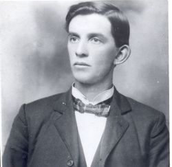
| Description | : | Herman C. Dillehay, 67, 2135 Avenue G, died at a Council Bluffs Hospital after a long illness. He was born at Holdrege, Neb. and had been in Council Bluffs 27 years. He was a retired carpenter and a member of the Carpenters Local 364, Excelsior Lodge 259, AF & A.M. and Epworth United Methodist Church. Survivors include his widow, Pearl E.; son David of Council Bluffs; daughter, Mrs. Nancy Monahan of Glenwood; three brother, Omar of Carroll, Duane of Marion and Bruce, address unknown; three sisters, Mrs. Ruby Jessen of Arcadia, Calif., Mrs. Eula Schaffer of Pleasanton, Calif. and Mrs.... Read More |
frequently asked questions (FAQ):
-
Where is Herman Clarence Dillehay's memorial?
Herman Clarence Dillehay's memorial is located at: Ridgewood Cemetery, Council Bluffs, Pottawattamie County, USA.
-
When did Herman Clarence Dillehay death?
Herman Clarence Dillehay death on 6 Aug 1974 in Council Bluffs, Pottawattamie County, Iowa, USA
-
Where are the coordinates of the Herman Clarence Dillehay's memorial?
Latitude: 41.2694016
Longitude: -95.8272018
Family Members:
Spouse

Siblings
Children
Flowers:


Nearby Cemetories:
1. Ridgewood Cemetery
Council Bluffs, Pottawattamie County, USA
Coordinate: 41.2694016, -95.8272018
2. Walnut Hill Cemetery
Council Bluffs, Pottawattamie County, USA
Coordinate: 41.2719002, -95.8255997
3. Bikhor Cholim Cemetery
Council Bluffs, Pottawattamie County, USA
Coordinate: 41.2703670, -95.8229350
4. Oak Hill Cemetery
Council Bluffs, Pottawattamie County, USA
Coordinate: 41.2700900, -95.8226400
5. Memorial Park Cemetery
Council Bluffs, Pottawattamie County, USA
Coordinate: 41.2644005, -95.8261032
6. Saint Joseph Cemetery
Council Bluffs, Pottawattamie County, USA
Coordinate: 41.2722015, -95.8208008
7. Green Valley Cemetery
Council Bluffs, Pottawattamie County, USA
Coordinate: 41.2743988, -95.8225021
8. Cedar Lawn Cemetery
Council Bluffs, Pottawattamie County, USA
Coordinate: 41.2694016, -95.8182983
9. Clark Cemetery
Pottawattamie County, USA
Coordinate: 41.2551610, -95.8223390
10. Fairview Cemetery
Council Bluffs, Pottawattamie County, USA
Coordinate: 41.2703018, -95.8480988
11. Garner Cemetery
Council Bluffs, Pottawattamie County, USA
Coordinate: 41.2956161, -95.8001709
12. Stoker-Graybill Cemetery
Council Bluffs, Pottawattamie County, USA
Coordinate: 41.2532620, -95.7751770
13. Maple Grove Cemetery
Council Bluffs, Pottawattamie County, USA
Coordinate: 41.2265560, -95.8187100
14. Evans Cemetery
Crescent, Pottawattamie County, USA
Coordinate: 41.3255997, -95.8368988
15. Lewis Township Cemetery
Council Bluffs, Pottawattamie County, USA
Coordinate: 41.2117004, -95.7938995
16. Gregg Cemetery
Weston, Pottawattamie County, USA
Coordinate: 41.3330000, -95.7931000
17. Council Point Cemetery
Council Bluffs, Pottawattamie County, USA
Coordinate: 41.2110830, -95.8788610
18. Hazel Dell Cemetery
Council Bluffs, Pottawattamie County, USA
Coordinate: 41.3489723, -95.7939911
19. Trinity Cathedral Columbarium
Omaha, Douglas County, USA
Coordinate: 41.2603900, -95.9393660
20. Saint Columbanus Cemetery
Weston, Pottawattamie County, USA
Coordinate: 41.3429440, -95.7435260
21. Crescent Cemetery
Crescent, Pottawattamie County, USA
Coordinate: 41.3664894, -95.8566208
22. Prospect Hill Cemetery
Omaha, Douglas County, USA
Coordinate: 41.2780991, -95.9593964
23. First Central Congregational Columbarium
Omaha, Douglas County, USA
Coordinate: 41.2563456, -95.9658365
24. Nash Chapel Crypt
Omaha, Douglas County, USA
Coordinate: 41.2665090, -95.9721790