
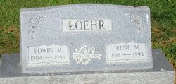
Irene Marie Weiland Loehr
| Birth | : | 26 Jun 1899 Earling, Shelby County, Iowa, USA |
| Death | : | 31 Mar 1995 Manilla, Crawford County, Iowa, USA |
| Burial | : | Sleaford Cemetery, Sleaford, North Kesteven District, England |
| Coordinate | : | 53.0027590, -0.4056790 |
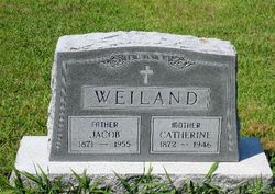
| Description | : | Irene Loehr, 95 June 26, 1899 - Mar. 31,1995 Defiance - Irene Marie Loehr, daughter of Jacob and Catherine (Kuhl) Weiland was born June 26, 1899 at Earling. She was baptized at St. Joseph's Catholic Church in Earling. In 1905, she along with her parents and family moved to a farm northwest of Defiance. She attended school, was confirmed at St. Peter's Catholic Church in Defiance and grew to adulthood in the Defiance area. After completing her education she worked in a cafe and for other area families. June 17, 1929 she married Edwin M, Loehr at Defiance. Three children were born... Read More |
frequently asked questions (FAQ):
-
Where is Irene Marie Weiland Loehr's memorial?
Irene Marie Weiland Loehr's memorial is located at: Sleaford Cemetery, Sleaford, North Kesteven District, England.
-
When did Irene Marie Weiland Loehr death?
Irene Marie Weiland Loehr death on 31 Mar 1995 in Manilla, Crawford County, Iowa, USA
-
Where are the coordinates of the Irene Marie Weiland Loehr's memorial?
Latitude: 53.0027590
Longitude: -0.4056790
Family Members:
Parent

Spouse

Siblings
Children
Flowers:


Nearby Cemetories:
1. Sleaford Cemetery
Sleaford, North Kesteven District, England
Coordinate: 53.0027590, -0.4056790
2. St Denys Churchyard
Sleaford, North Kesteven District, England
Coordinate: 52.9996510, -0.4088960
3. St Botolph Churchyard
Quarrington, North Kesteven District, England
Coordinate: 52.9872010, -0.4312350
4. St Andrew Churchyard
Leasingham, North Kesteven District, England
Coordinate: 53.0239040, -0.4262600
5. St. Denys Churchyard
Kirkby la Thorpe, North Kesteven District, England
Coordinate: 53.0008270, -0.3636800
6. St. Denis Churchyard
Silk Willoughby, North Kesteven District, England
Coordinate: 52.9738460, -0.4268830
7. St Denys Churchyard
Silk Willoughby, North Kesteven District, England
Coordinate: 52.9736976, -0.4263297
8. Rauceby Hospital Cemetery
Quarrington, North Kesteven District, England
Coordinate: 52.9807077, -0.4549731
9. St. Andrew's Churchyard
Asgarby, North Kesteven District, England
Coordinate: 52.9941750, -0.3383450
10. St Peter's Churchyard
North Rauceby, North Kesteven District, England
Coordinate: 53.0056400, -0.4796500
11. All Saints Churchyard
Ruskington, North Kesteven District, England
Coordinate: 53.0460330, -0.3866280
12. St Andrew Churchyard
Cranwell, North Kesteven District, England
Coordinate: 53.0370660, -0.4612070
13. St Edith's Church
Anwick, North Kesteven District, England
Coordinate: 53.0414520, -0.3391170
14. Anwick Church Lane Churchyard Extension
Anwick, North Kesteven District, England
Coordinate: 53.0420800, -0.3397200
15. St. Andrew's Churchyard
Scredington, North Kesteven District, England
Coordinate: 52.9498300, -0.3701700
16. St. Andrew Churchyard
Burton Pedwardine, North Kesteven District, England
Coordinate: 52.9646176, -0.3348618
17. St. Oswald's Churchyard
Howell, North Kesteven District, England
Coordinate: 53.0016300, -0.3100400
18. All Saints Churchyard
Brauncewell, North Kesteven District, England
Coordinate: 53.0587900, -0.4418200
19. St. Mary's Churchyard
Wilsford, North Kesteven District, England
Coordinate: 52.9751600, -0.5023700
20. St. Andrew's Churchyard
Heckington, North Kesteven District, England
Coordinate: 52.9822000, -0.2990800
21. St Thomas Churchyard
Aunsby, North Kesteven District, England
Coordinate: 52.9367820, -0.4470450
22. Heckington Cemetery
Heckington, North Kesteven District, England
Coordinate: 52.9803830, -0.2920010
23. St Peter & St Paul Churchyard
Osbournby, North Kesteven District, England
Coordinate: 52.9298800, -0.4105100
24. St Andrew Churchyard
Kelby, North Kesteven District, England
Coordinate: 52.9608000, -0.5074000