
| Birth | : | 6 Jan 1921 Tennessee, USA |
| Death | : | 4 Oct 2008 Bells, Crockett County, Tennessee, USA |
| Burial | : | Bellevernon Cemetery, Friendship, Crockett County, USA |
| Coordinate | : | 35.9135830, -89.2495910 |
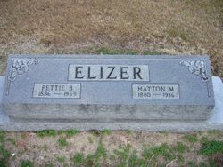
| Description | : | James Thomas Elizer, age 87 of Bells, Tennessee, died on Saturday, October 4, 2008 at Bells Nursing Home. He was born in Friendship, Tennessee, s on of Hatton Malone and Pettie Bledsoe Elizer. After graduation from Friendship High School in 1938, he worked in the banking business for Bank of Friendship and American National Bank in Nashville, TN before enlisting in the U.S. Army in March 1942. He piloted a Liberator bomber on over thirty successful missions over Germ any and France during World War II in 1943-44. He was promoted to First Lieutenant and was awarded the Distinguished... Read More |
frequently asked questions (FAQ):
-
Where is James Thomas Elizer's memorial?
James Thomas Elizer's memorial is located at: Bellevernon Cemetery, Friendship, Crockett County, USA.
-
When did James Thomas Elizer death?
James Thomas Elizer death on 4 Oct 2008 in Bells, Crockett County, Tennessee, USA
-
Where are the coordinates of the James Thomas Elizer's memorial?
Latitude: 35.9135830
Longitude: -89.2495910
Family Members:
Parent
Siblings
Flowers:


Nearby Cemetories:
1. Bellevernon Cemetery
Friendship, Crockett County, USA
Coordinate: 35.9135830, -89.2495910
2. Friendship Cemetery
Friendship, Crockett County, USA
Coordinate: 35.9146430, -89.2381450
3. Mount Moriah Cemetery
Friendship, Crockett County, USA
Coordinate: 35.8955420, -89.2576300
4. Bowen Chapel Cemetery
Friendship, Dyer County, USA
Coordinate: 35.9311810, -89.2353720
5. Mose M. Thompson Cemetery
Friendship, Dyer County, USA
Coordinate: 35.9243680, -89.2765870
6. Hardin Cemetery
Friendship, Dyer County, USA
Coordinate: 35.9243270, -89.2766430
7. Nash Cemetery
Dyersburg, Dyer County, USA
Coordinate: 35.9252500, -89.2822230
8. Robertson-Warren Cemetery
Friendship, Crockett County, USA
Coordinate: 35.8830700, -89.2427200
9. Mount Pisgah Cemetery
Friendship, Dyer County, USA
Coordinate: 35.9162470, -89.2901740
10. Zion Hill Church Cemetery
Friendship, Dyer County, USA
Coordinate: 35.9095110, -89.2900760
11. Edwards Cemetery
Friendship, Crockett County, USA
Coordinate: 35.9314120, -89.2146810
12. Deaton Cemetery
Friendship, Crockett County, USA
Coordinate: 35.9350080, -89.2122640
13. Mount Zion Cemetery
Friendship, Crockett County, USA
Coordinate: 35.9131950, -89.2032590
14. Staggs Cemetery
Friendship, Dyer County, USA
Coordinate: 35.9397930, -89.2896620
15. Old Dyer Church Cemetery
Friendship, Crockett County, USA
Coordinate: 35.8844600, -89.2101900
16. Allen Chapel Cemetery
Tigrett, Dyer County, USA
Coordinate: 35.9511400, -89.2207500
17. Hendrix Cemetery
Tigrett, Dyer County, USA
Coordinate: 35.9511500, -89.2206950
18. Cock and Irvin Cemetery
Hawkinsville, Dyer County, USA
Coordinate: 35.9104430, -89.3046210
19. Mays Chapel Cemetery
Friendship, Crockett County, USA
Coordinate: 35.9363540, -89.2006050
20. Jones Cemetery
Tigrett, Dyer County, USA
Coordinate: 35.9552230, -89.2747450
21. Saint Peter Cemetery
Tigrett, Dyer County, USA
Coordinate: 35.9616440, -89.2520140
22. Williams Chapel Baptist Church Cemetery
Friendship, Crockett County, USA
Coordinate: 35.9258940, -89.1916320
23. Browder Family Cemetery
Broadview, Crockett County, USA
Coordinate: 35.8646890, -89.2623010
24. McGary Family Cemetery
Tigrett, Dyer County, USA
Coordinate: 35.9649530, -89.2501520