
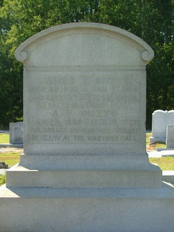
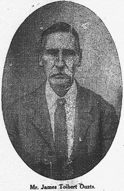
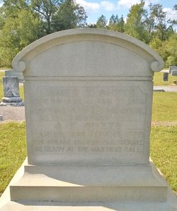
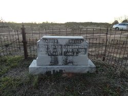
James Tolbert “Jim” Ouzts
| Birth | : | 30 Dec 1833 Meeting Street, Edgefield County, South Carolina, USA |
| Death | : | 27 Jan 1914 Meeting Street, Edgefield County, South Carolina, USA |
| Burial | : | Ryde Cemetery, Ryde, Isle of Wight Unitary Authority, England |
| Coordinate | : | 50.7249730, -1.1668550 |
| Description | : | Grew up on his father's farm, doing such work as his strength allowed. He had neuralgia all his life and few except his family knew the intense suffering he endured. James Talbert was a poet and kept a Journal of the important events of his life [from 1855-1882] Included in the Journal are some of James' poems he wrote at his father's home "Oak Lawn" to Frances Ann (Fannie) Lowrey, whom he married. James began life as a small farmer but as time passed he became quite successful. In the early 1870's he began a country... Read More |
frequently asked questions (FAQ):
-
Where is James Tolbert “Jim” Ouzts's memorial?
James Tolbert “Jim” Ouzts's memorial is located at: Ryde Cemetery, Ryde, Isle of Wight Unitary Authority, England.
-
When did James Tolbert “Jim” Ouzts death?
James Tolbert “Jim” Ouzts death on 27 Jan 1914 in Meeting Street, Edgefield County, South Carolina, USA
-
Where are the coordinates of the James Tolbert “Jim” Ouzts's memorial?
Latitude: 50.7249730
Longitude: -1.1668550
Family Members:
Parent
Spouse
Siblings
Children
Flowers:


Nearby Cemetories:
1. Ryde Cemetery
Ryde, Isle of Wight Unitary Authority, England
Coordinate: 50.7249730, -1.1668550
2. St Thomas Churchyard
Ryde, Isle of Wight Unitary Authority, England
Coordinate: 50.7305600, -1.1632540
3. Binstead Cemetery
Binstead, Isle of Wight Unitary Authority, England
Coordinate: 50.7264610, -1.1866180
4. St Cecilia's Abbey
Ryde, Isle of Wight Unitary Authority, England
Coordinate: 50.7279800, -1.1463120
5. Holy Cross Churchyard
Binstead, Isle of Wight Unitary Authority, England
Coordinate: 50.7320080, -1.1863070
6. St. Johns Churchyard
Ryde, Isle of Wight Unitary Authority, England
Coordinate: 50.7149770, -1.1482370
7. Quarr Old Abbey
Ryde, Isle of Wight Unitary Authority, England
Coordinate: 50.7310000, -1.1996000
8. Quarr Abbey
Binstead, Isle of Wight Unitary Authority, England
Coordinate: 50.7311862, -1.2034333
9. St Peter's
Havenstreet, Isle of Wight Unitary Authority, England
Coordinate: 50.7095580, -1.2063290
10. St. Edmund's Churchyard
Wootton, Isle of Wight Unitary Authority, England
Coordinate: 50.7308220, -1.2344490
11. St Mary the Virgin Churchyard
Brading, Isle of Wight Unitary Authority, England
Coordinate: 50.6824400, -1.1429600
12. Isle of Wight Crematorium
Whippingham, Isle of Wight Unitary Authority, England
Coordinate: 50.7217910, -1.2573910
13. St. Mark's Churchyard
Alverstoke, Gosport Borough, England
Coordinate: 50.7826800, -1.1436100
14. Clayhall Naval Cemetery
Gosport, Gosport Borough, England
Coordinate: 50.7833862, -1.1373420
15. Turkish Naval Cemetery
Gosport, Gosport Borough, England
Coordinate: 50.7840710, -1.1383980
16. St Mary Churchyard
Alverstoke, Gosport Borough, England
Coordinate: 50.7856760, -1.1480810
17. Lane End Cemetery
Bembridge, Isle of Wight Unitary Authority, England
Coordinate: 50.6863554, -1.0809575
18. St. Mildred's Churchyard
Whippingham, Isle of Wight Unitary Authority, England
Coordinate: 50.7398230, -1.2768350
19. Christ Churchyard
Sandown, Isle of Wight Unitary Authority, England
Coordinate: 50.6521319, -1.1621056
20. Portsmouth Naval Memorial
Portsmouth, Portsmouth Unitary Authority, England
Coordinate: 50.7824440, -1.0957720
21. Ann's Hill Cemetery
Gosport, Gosport Borough, England
Coordinate: 50.7982670, -1.1549450
22. Holy Trinity Churchyard
Gosport, Gosport Borough, England
Coordinate: 50.7930600, -1.1207620
23. Lake Cemetery
Lake, Isle of Wight Unitary Authority, England
Coordinate: 50.6498713, -1.1734786
24. Royal Garrison Church Churchyard
Plymouth, Plymouth Unitary Authority, England
Coordinate: 50.7889690, -1.1039650