

Jennie Crawford McDougall
| Birth | : | 1812 Scotland |
| Death | : | 18 Feb 1882 Perth, Lanark County, Ontario, Canada |
| Burial | : | Oakham Cemetery, Oakham, Rutland Unitary Authority, England |
| Coordinate | : | 52.6768700, -0.7297400 |
| Plot | : | 145 |
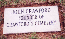
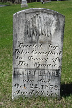
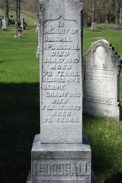
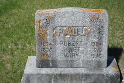
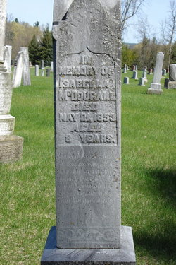
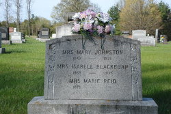
| Description | : | Jennie was born in Woodside, Scotland, the daughter of John Crawford and Janet Bryce. She came to Canada with her parents, settling in Lanark County, Ontario. She was married to Dougall McDougall, son of Alexander McDougall and Janet Clark. -------------------------------------- Plot 145 : (side 1 of stone) - In memory of, - Dougall McDougall, died Jan.17,1887, aged 79 years - also his wife, Jennie Crawford, died Feb.18,1882, aged 70 years. (side 2 of stone) - In meory of Isabella McDougall, died May 21,1853, aged 8 years. |
frequently asked questions (FAQ):
-
Where is Jennie Crawford McDougall's memorial?
Jennie Crawford McDougall's memorial is located at: Oakham Cemetery, Oakham, Rutland Unitary Authority, England.
-
When did Jennie Crawford McDougall death?
Jennie Crawford McDougall death on 18 Feb 1882 in Perth, Lanark County, Ontario, Canada
-
Where are the coordinates of the Jennie Crawford McDougall's memorial?
Latitude: 52.6768700
Longitude: -0.7297400
Family Members:
Parent
Spouse
Siblings
Children


Flowers:


Nearby Cemetories:
1. Oakham Cemetery
Oakham, Rutland Unitary Authority, England
Coordinate: 52.6768700, -0.7297400
2. SS Peter and Paul Church
Langham, Rutland Unitary Authority, England
Coordinate: 52.6918700, -0.7529300
3. St Mary the Virgin Churchyard
Ashwell, Rutland Unitary Authority, England
Coordinate: 52.7144490, -0.7200580
4. St Andrew Churchyard
Hambleton, Rutland Unitary Authority, England
Coordinate: 52.6585060, -0.6712280
5. St John the Baptist Churchyard
Cold Overton, Melton Borough, England
Coordinate: 52.6829560, -0.8027660
6. St Andrew Churchyard
Whissendine, Rutland Unitary Authority, England
Coordinate: 52.7200520, -0.7682370
7. St. Nicholas Churchyard
Cottesmore, Rutland Unitary Authority, England
Coordinate: 52.7128800, -0.6655820
8. St Peter Churchyard
Knossington, Melton Borough, England
Coordinate: 52.6699000, -0.8168600
9. St Peter and St Paul Churchyard
Exton, Rutland Unitary Authority, England
Coordinate: 52.6905790, -0.6396910
10. Holy Trinity Churchyard
Teigh, Rutland Unitary Authority, England
Coordinate: 52.7348560, -0.7207040
11. St Peter & Paul Churchyard
Preston, Rutland Unitary Authority, England
Coordinate: 52.6122600, -0.7162560
12. Saint Peter and Saint Paul's Churchyard
Market Overton, Rutland Unitary Authority, England
Coordinate: 52.7385000, -0.6893000
13. St. Peter and St. Paul's Churchyard
Wing, Rutland Unitary Authority, England
Coordinate: 52.6172140, -0.6814150
14. Withcote Chapel
Harborough District, England
Coordinate: 52.6440500, -0.8253346
15. All Saints Churchyard, Pickwell
Melton Mowbray, Melton Borough, England
Coordinate: 52.6943280, -0.8388740
16. Pickwell Road Cemetery
Somerby, Melton Borough, England
Coordinate: 52.6865550, -0.8444540
17. St Mary the Virgin Churchyard
Edith Weston, Rutland Unitary Authority, England
Coordinate: 52.6379100, -0.6311100
18. Saint Michael and All Angels Churchyard
Edmondthorpe, Melton Borough, England
Coordinate: 52.7488800, -0.7301600
19. Edmondthorpe Main Street Cemetery
Edmondthorpe, Melton Borough, England
Coordinate: 52.7491560, -0.7300030
20. All Saints Churchyard
Somerby, Melton Borough, England
Coordinate: 52.6864700, -0.8482390
21. Launde Abbey
Launde, Harborough District, England
Coordinate: 52.6313950, -0.8233060
22. St Mary the Virgin Churchyard
Greetham, Rutland Unitary Authority, England
Coordinate: 52.7216100, -0.6325650
23. St Nicholas Churchyard
Pilton, Rutland Unitary Authority, England
Coordinate: 52.6165200, -0.6504100
24. St. Mary the Virgin Churchyard
Uppingham, Rutland Unitary Authority, England
Coordinate: 52.5996800, -0.7324400