
| Birth | : | 9 Sep 1943 Dunlap, Harrison County, Iowa, USA |
| Death | : | 7 Jun 2015 Missouri Valley, Harrison County, Iowa, USA |
| Burial | : | Branson Cemetery, Loveland, Pottawattamie County, USA |
| Coordinate | : | 41.4846992, -95.8606033 |
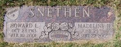
| Inscription | : | Jerald E Davis PO 3 US Navy Vietnam Sep 9 1943 + Jun 7 2015 DAVIS Jerald E. Sep. 9, 1943 Jun. 7, 2015 -Sep. 2, 1983- Jennie L. Oct. 7, 1934 |
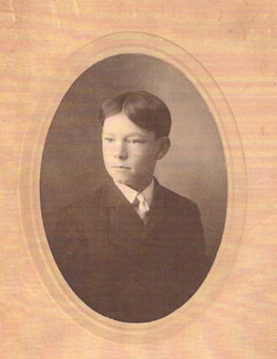
| Description | : | Jerald E. Davis, 71, of Mondamin, passed away on June 7, at Longview Nursing Home in Missouri Valley. Jerald was born on Sept. 9, 1943, to Fred and Pearl Lewis Davis in Dunlap. Jerald was united in marriage to his wife Jennie Davis on Sept. 2, 1983. He was a lifetime member of the Veteran of Foreign Wars. Jerald was a machinist at Vickers for 33 years. During the Vietnam War, Jerald delivered ammunition to the soldiers. He always put on a grand Fourth of July Celebration. He enjoyed gardening, tractors, fishing, and having fish fries.... Read More |
frequently asked questions (FAQ):
-
Where is Jerald Edward Davis's memorial?
Jerald Edward Davis's memorial is located at: Branson Cemetery, Loveland, Pottawattamie County, USA.
-
When did Jerald Edward Davis death?
Jerald Edward Davis death on 7 Jun 2015 in Missouri Valley, Harrison County, Iowa, USA
-
Where are the coordinates of the Jerald Edward Davis's memorial?
Latitude: 41.4846992
Longitude: -95.8606033
Family Members:
Parent
Spouse

Siblings


Flowers:


Nearby Cemetories:
1. Branson Cemetery
Loveland, Pottawattamie County, USA
Coordinate: 41.4846992, -95.8606033
2. Crook Cemetery
Honey Creek, Pottawattamie County, USA
Coordinate: 41.4581330, -95.8737000
3. Saint Bridgets Cemetery
Honey Creek, Pottawattamie County, USA
Coordinate: 41.4664001, -95.8289032
4. Oak Grove Cemetery
Missouri Valley, Harrison County, USA
Coordinate: 41.5167007, -95.8649979
5. Allen Cemetery
Pottawattamie County, USA
Coordinate: 41.4427986, -95.8550034
6. Grange Cemetery
Honey Creek, Pottawattamie County, USA
Coordinate: 41.4446678, -95.8034668
7. Reels Cemetery
Crescent, Pottawattamie County, USA
Coordinate: 41.4234100, -95.8321700
8. William C McIntosh Cemetery
Crescent, Pottawattamie County, USA
Coordinate: 41.4088745, -95.8477097
9. Rose Hill Memorial Gardens
Missouri Valley, Harrison County, USA
Coordinate: 41.5656000, -95.8897000
10. Hurleys Evergreen Cemetery
Harrison County, USA
Coordinate: 41.5700989, -95.8618698
11. Mount Carmel Cemetery
Missouri Valley, Harrison County, USA
Coordinate: 41.5675011, -95.8897018
12. Saint Pauls Lutheran Cemetery
Neola, Pottawattamie County, USA
Coordinate: 41.4337000, -95.7607000
13. Champan Frazier Cemetery
Harrison County, USA
Coordinate: 41.5773500, -95.8933500
14. Frazier Cemetery
Missouri Valley, Harrison County, USA
Coordinate: 41.5932999, -95.8375015
15. Linnwood Cemetery
Harrison County, USA
Coordinate: 41.5589200, -95.7502100
16. Crescent Cemetery
Crescent, Pottawattamie County, USA
Coordinate: 41.3664894, -95.8566208
17. Shipley Cemetery
Washington County, USA
Coordinate: 41.3932991, -95.9828033
18. Fort Calhoun Cemetery
Fort Calhoun, Washington County, USA
Coordinate: 41.4581375, -96.0352020
19. Harris Grove Cemetery
Beebeetown, Harrison County, USA
Coordinate: 41.5782928, -95.7262192
20. Hazel Dell Cemetery
Council Bluffs, Pottawattamie County, USA
Coordinate: 41.3489723, -95.7939911
21. Castor Cemetery
Underwood, Pottawattamie County, USA
Coordinate: 41.4127040, -95.6887490
22. Calhoun Cemetery
Calhoun, Harrison County, USA
Coordinate: 41.6391983, -95.8938980
23. Gregg Cemetery
Weston, Pottawattamie County, USA
Coordinate: 41.3330000, -95.7931000
24. Evans Cemetery
Crescent, Pottawattamie County, USA
Coordinate: 41.3255997, -95.8368988