
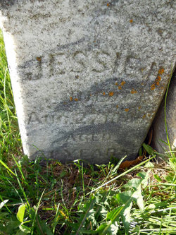
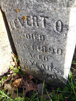
Jessie H Westenhaver
| Birth | : | 2 Mar 1868 Perlee, Jefferson County, Iowa, USA |
| Death | : | 27 Aug 1889 Fairfield, Jefferson County, Iowa, USA |
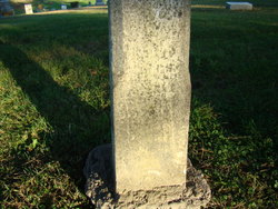
| Burial | : | Howick Cemetery, Howick, Auckland Council, New Zealand |
| Coordinate | : | -36.9040400, 174.9380500 |
| Plot | : | Lot 17 East side of cemetery |
| Description | : | The Fairfield Tribune Aug. 29, 1889 and Sept 11, 1889. DIED, in this city, August 27, of consumption, Miss Jessie H. Westenhaver; born Mar. 2, 1868 near Perlee in this county.....Her mother died eight years ago. Since that time she kept house for her father and brother..... |
frequently asked questions (FAQ):
-
Where is Jessie H Westenhaver's memorial?
Jessie H Westenhaver's memorial is located at: Howick Cemetery, Howick, Auckland Council, New Zealand.
-
When did Jessie H Westenhaver death?
Jessie H Westenhaver death on 27 Aug 1889 in Fairfield, Jefferson County, Iowa, USA
-
Where are the coordinates of the Jessie H Westenhaver's memorial?
Latitude: -36.9040400
Longitude: 174.9380500
Family Members:
Parent
Siblings
Flowers:


Nearby Cemetories:
1. Howick Cemetery
Howick, Auckland Council, New Zealand
Coordinate: -36.9040400, 174.9380500
2. All Saints Cemetery
Howick, Auckland Council, New Zealand
Coordinate: -36.8954260, 174.9337600
3. Our Lady Star of the Sea Parish Cemetery
Howick, Auckland Council, New Zealand
Coordinate: -36.8932940, 174.9307940
4. St. Andrew Presbyterian Cemetery
Howick, Auckland Council, New Zealand
Coordinate: -36.8989900, 174.9201600
5. Howick Historical Village
Pakuranga, Auckland Council, New Zealand
Coordinate: -36.9067680, 174.9027080
6. Pakuranga Methodist Cemetery
Pakuranga, Auckland Council, New Zealand
Coordinate: -36.9054000, 174.8914900
7. Waikopua Cemetery
Whitford, Auckland Council, New Zealand
Coordinate: -36.9274400, 174.9998900
8. Flat Bush Cemetery
East Tamaki, Auckland Council, New Zealand
Coordinate: -36.9563500, 174.9097100
9. St. John's Church Cemetery
East Tamaki, Auckland Council, New Zealand
Coordinate: -36.9522250, 174.8964540
10. St. Paul's Anglican Cemetery
East Tamaki, Auckland Council, New Zealand
Coordinate: -36.9615200, 174.9082000
11. St Matthias Churchyard
Panmure, Auckland Council, New Zealand
Coordinate: -36.9053300, 174.8577200
12. St. Patrick's Roman Catholic Church Cemetery
Panmure, Auckland Council, New Zealand
Coordinate: -36.9029680, 174.8564960
13. Point England Presbyterian Cemetery
Point England, Auckland Council, New Zealand
Coordinate: -36.8823420, 174.8601550
14. St. Joseph and St. Joachim Catholic Cemetery
Ōtāhūhū, Auckland Council, New Zealand
Coordinate: -36.9436100, 174.8490100
15. Holy Trinity Memorial Park
Ōtāhūhū, Auckland Council, New Zealand
Coordinate: -36.9374510, 174.8448580
16. St. Thomas Churchyard
Tamaki, Auckland Council, New Zealand
Coordinate: -36.8675590, 174.8460560
17. St. John’s College Graveyard
Saint Johns, Auckland Council, New Zealand
Coordinate: -36.8738169, 174.8416826
18. Otahuhu Public Cemetery
Ōtāhūhū, Auckland Council, New Zealand
Coordinate: -36.9377500, 174.8432390
19. Nixon Memorial
Ōtāhūhū, Auckland Council, New Zealand
Coordinate: -36.9499366, 174.8449909
20. St. John's Presbyterian Church Cemetery
Papatoetoe, Auckland Council, New Zealand
Coordinate: -36.9674185, 174.8598178
21. Purewa Cemetery
Meadowbank, Auckland Council, New Zealand
Coordinate: -36.8674300, 174.8297900
22. Woodside Methodist Cemetery
Manukau, Auckland Council, New Zealand
Coordinate: -36.9929680, 174.8837860
23. Motuihe Island Cemetery
Auckland Council, New Zealand
Coordinate: -36.8000400, 174.9363920
24. Ōrākei (Rautara St) Urupā
Orakei, Auckland Council, New Zealand
Coordinate: -36.8610770, 174.8188960