
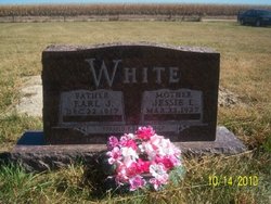
Jessie L. Fancolly White
| Birth | : | 22 Mar 1927 Atlantic, Cass County, Iowa, USA |
| Death | : | 9 Sep 2010 Kearney, Buffalo County, Nebraska, USA |
| Burial | : | Riverside Cemetery, Crow Wing County, USA |
| Coordinate | : | 46.2224998, -94.1893997 |
| Description | : | Jessie L. White, 83, of Kearney, formerly of Lexington, died Thursday, Sept. 9, 2010, at Good Samaritan Hospital in Kearney. Jessie was born March 22, 1927, at Atlantic, Iowa to Roy and Mary (Judd) Fancolly. Jessie attended school and graduated from Atlantic High School in Atlantic, Iowa with the class of 1946. She was united in marriage to Earl White on November 30, 1947, at Atlantic. Four children were blessed to this marriage; Alan, Arlyn, Paul and Carolyn. Earl and Jessie loved children and they housed children in their home when they needed a place to live. She was a wonderful... Read More |
frequently asked questions (FAQ):
-
Where is Jessie L. Fancolly White's memorial?
Jessie L. Fancolly White's memorial is located at: Riverside Cemetery, Crow Wing County, USA.
-
When did Jessie L. Fancolly White death?
Jessie L. Fancolly White death on 9 Sep 2010 in Kearney, Buffalo County, Nebraska, USA
-
Where are the coordinates of the Jessie L. Fancolly White's memorial?
Latitude: 46.2224998
Longitude: -94.1893997
Family Members:
Spouse

Children
Flowers:


Nearby Cemetories:
1. Riverside Cemetery
Crow Wing County, USA
Coordinate: 46.2224998, -94.1893997
2. Saint Mathias Catholic Cemetery
Saint Mathias, Crow Wing County, USA
Coordinate: 46.2200000, -94.2517000
3. Pine Tree Cemetery
Crow Wing County, USA
Coordinate: 46.2122000, -94.1214000
4. Hillside Cemetery
Long Lake Township, Crow Wing County, USA
Coordinate: 46.2577000, -94.1037000
5. Pine Grove Cemetery
Crow Wing County, USA
Coordinate: 46.1713000, -94.2725000
6. Oak Land Cemetery
Crow Wing County, USA
Coordinate: 46.2722015, -94.3043976
7. Dixon Cemetery
Fort Ripley, Crow Wing County, USA
Coordinate: 46.2154930, -94.3246630
8. Oak Hill Cemetery
Crow Wing County, USA
Coordinate: 46.2158012, -94.3285980
9. Saint Francis Assisi Cemetery
Brainerd, Crow Wing County, USA
Coordinate: 46.2752980, -94.3352060
10. Saint John Holy Cross Cemetery
Brainerd, Crow Wing County, USA
Coordinate: 46.2790970, -94.3328890
11. Bethel Lutheran Cemetery
Crow Wing County, USA
Coordinate: 46.3147200, -94.0827800
12. Fort Ripley Cemetery
Fort Ripley, Crow Wing County, USA
Coordinate: 46.1761000, -94.3615700
13. Saint Marys Catholic Community Cemetery
Pierz, Morrison County, USA
Coordinate: 46.1093620, -94.0818390
14. Saint Pauls Episcopal Church Columbarium
Brainerd, Crow Wing County, USA
Coordinate: 46.3604205, -94.1988906
15. Vaale Cemetery
Brainerd, Crow Wing County, USA
Coordinate: 46.3224800, -94.0493950
16. Baxter Cemetery
Baxter, Crow Wing County, USA
Coordinate: 46.3455600, -94.2855600
17. Holy Cross Cemetery
Platte, Morrison County, USA
Coordinate: 46.1042000, -94.0813620
18. Evergreen Cemetery
Brainerd, Crow Wing County, USA
Coordinate: 46.3708000, -94.1859000
19. Holy Cross Church Cemetery
Pierz, Morrison County, USA
Coordinate: 46.1137400, -94.0408200
20. Freedhem Lutheran Cemetery
Freedhem, Morrison County, USA
Coordinate: 46.0612907, -94.2087021
21. Green Prairie Cemetery
Morrison County, USA
Coordinate: 46.1022400, -94.3527800
22. Freedhem Free Evangelical Cemetery
Freedhem, Morrison County, USA
Coordinate: 46.0559500, -94.2069600
23. Gull River Cemetery
Cass County, USA
Coordinate: 46.3356018, -94.3685989
24. Maple Grove Cemetery
Crow Wing County, USA
Coordinate: 46.3297005, -93.9993973