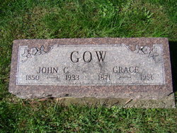
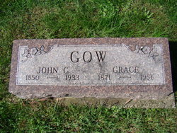
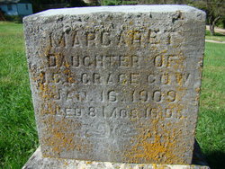
John Cole Gow
| Birth | : | 9 Jun 1850 Scotland |
| Death | : | 17 Jul 1933 Jefferson County, Iowa, USA |
| Burial | : | North Shore Memory Gardens, Coloma, Berrien County, USA |
| Coordinate | : | 42.2024994, -86.3908005 |
| Plot | : | 1st.067 |
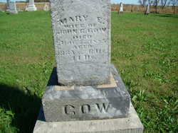
| Description | : | Husband of Grace Greenland Gow at the time of his death. Although not mentioned in the obituary, it would appear the he was previously married to a "Mary"; the 1929 obituary for his daughter Nellie Mae Gow Tuller states that she was the daughter of John C. and Mary Gow. Given that, the parentage of the children should be considered with some caution pending obituary, birth, or marriage information. Father of Margaret Gow. -------- Fairfield Daily Ledger Monday July 17, 1933 JOHN C. GOW TAKEN AFTER LONG ILLNESS Well Known County Resident Will be Buried Wednesday Here John C. GOW, 300 East Kirkwood street,... Read More |
frequently asked questions (FAQ):
-
Where is John Cole Gow's memorial?
John Cole Gow's memorial is located at: North Shore Memory Gardens, Coloma, Berrien County, USA.
-
When did John Cole Gow death?
John Cole Gow death on 17 Jul 1933 in Jefferson County, Iowa, USA
-
Where are the coordinates of the John Cole Gow's memorial?
Latitude: 42.2024994
Longitude: -86.3908005
Family Members:
Spouse
Children
Flowers:
Nearby Cemetories:
1. Curtis Cemetery
Hagar Township, Berrien County, USA
Coordinate: 42.1856003, -86.3544006
2. Harris Cemetery
Lake Michigan Beach, Berrien County, USA
Coordinate: 42.2144012, -86.3482971
3. Lake Shore Cemetery
Riverside, Berrien County, USA
Coordinate: 42.1669388, -86.4177780
4. Coloma Cemetery
Coloma, Berrien County, USA
Coordinate: 42.1860008, -86.3119965
5. Boyer Cemetery
Bainbridge Center, Berrien County, USA
Coordinate: 42.1572222, -86.3305556
6. Kniebes Cemetery
Coloma, Berrien County, USA
Coordinate: 42.1511002, -86.3071976
7. Millburg Cemetery
Millburg, Berrien County, USA
Coordinate: 42.1264000, -86.3486023
8. Saint Josephs Catholic Cemetery
Watervliet, Berrien County, USA
Coordinate: 42.1852989, -86.2722015
9. Baptist Cemetery
Bainbridge Center, Berrien County, USA
Coordinate: 42.1455600, -86.2947300
10. Morton Hill Cemetery
Benton Harbor, Berrien County, USA
Coordinate: 42.1194000, -86.4417038
11. Fish Cemetery
Covert, Van Buren County, USA
Coordinate: 42.2655983, -86.2981033
12. Saint Marys Catholic Church Cemetery
Watervliet, Berrien County, USA
Coordinate: 42.1450000, -86.2916670
13. Saint Pauls United Church of Christ Cemetery
Watervliet, Berrien County, USA
Coordinate: 42.1447222, -86.2819444
14. Watervliet Cemetery
Watervliet, Berrien County, USA
Coordinate: 42.1886110, -86.2536110
15. New Hope United Methodist Church Cemetery
Bainbridge Center, Berrien County, USA
Coordinate: 42.1380530, -86.2812620
16. Emmanuel Home Cemetery
Covert, Van Buren County, USA
Coordinate: 42.2508253, -86.2624946
17. B'nai Sholom Cemetery
Fair Plain, Berrien County, USA
Coordinate: 42.0938988, -86.4163971
18. Crystal Springs Cemetery
Benton Harbor, Berrien County, USA
Coordinate: 42.0918999, -86.4150009
19. Temple Beth El Memorial Park
Berrien County, USA
Coordinate: 42.0908660, -86.4154530
20. Pearl Cemetery
Benton Township, Berrien County, USA
Coordinate: 42.0905991, -86.3641968
21. Calvary Cemetery
Benton Harbor, Berrien County, USA
Coordinate: 42.0901820, -86.4196160
22. Fairview Memorial Cemetery
Watervliet, Berrien County, USA
Coordinate: 42.1969440, -86.2236110
23. Bainbridge Cemetery
Bainbridge Center, Berrien County, USA
Coordinate: 42.1156006, -86.2694016
24. Byers Cemetery
Bainbridge Center, Berrien County, USA
Coordinate: 42.1156700, -86.2680820

