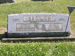
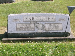
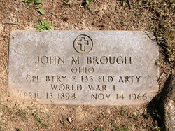
John Dennison Brough
| Birth | : | 16 Apr 1857 Iowa, USA |
| Death | : | 30 Oct 1948 Scio, Harrison County, Ohio, USA |
| Burial | : | Grandview Cemetery, Scio, Harrison County, USA |
| Coordinate | : | 40.3903008, -81.0978012 |
| Description | : | The Times Recorder, Zanesville, Ohio, Wednesday, November 3, 1948~ Rites Held For John D. Brough Funeral services for John D. Brough, 91, of Scio, were conducted from the Purvaince funeral home Monday afternoon with Rev. Hutchison officiating. Burial was in the Grandview cemetery at Scio. Mr. Brough died at his home Sunday following a long illness. A retired mail carrier he had been a resident of Scio for 50 years. He was a member of the Presbyterian church. Surviving are two sons, John Brough of Pittsburgh, and William Brough of Canton; two daughters, Mrs. Gladys Keys of East Liverpool and Miss Frances Brough of... Read More |
frequently asked questions (FAQ):
-
Where is John Dennison Brough's memorial?
John Dennison Brough's memorial is located at: Grandview Cemetery, Scio, Harrison County, USA.
-
When did John Dennison Brough death?
John Dennison Brough death on 30 Oct 1948 in Scio, Harrison County, Ohio, USA
-
Where are the coordinates of the John Dennison Brough's memorial?
Latitude: 40.3903008
Longitude: -81.0978012
Family Members:
Parent
Spouse
Siblings
Children
Flowers:
Nearby Cemetories:
1. Grandview Cemetery
Scio, Harrison County, USA
Coordinate: 40.3903008, -81.0978012
2. Methodist Episcopal Church Cemetery
Scio, Harrison County, USA
Coordinate: 40.3970800, -81.0864600
3. Hanover Cemetery
Harrison County, USA
Coordinate: 40.3700600, -81.0670400
4. Wood Cemetery
Scio, Harrison County, USA
Coordinate: 40.4193500, -81.0707690
5. Ridgeview Cemetery
Scio, Harrison County, USA
Coordinate: 40.3620900, -81.0566400
6. Conotton Cemetery
Harrison County, USA
Coordinate: 40.4103012, -81.1489029
7. Mount Hope Cemetery
Tappan, Harrison County, USA
Coordinate: 40.3466400, -81.1237360
8. United Brethren Cemetery
Harrison County, USA
Coordinate: 40.4043999, -81.0353012
9. New Rumley Methodist Cemetery
New Rumley, Harrison County, USA
Coordinate: 40.4028015, -81.0346985
10. Conaway Cemetery
Bowerston, Harrison County, USA
Coordinate: 40.3384420, -81.0889720
11. Evangelical Lutheran Cemetery
New Rumley, Harrison County, USA
Coordinate: 40.4019012, -81.0271988
12. Beaver Valley Cemetery
Monroe Township, Harrison County, USA
Coordinate: 40.3779100, -81.1703860
13. Allen Memorial Cemetery
Carroll County, USA
Coordinate: 40.4364014, -81.0511017
14. Hagey Family Cemetery
Perrysville, Carroll County, USA
Coordinate: 40.4525980, -81.0996160
15. Mount Zion African Methodist Episcopal Cemetery
Conotton, Harrison County, USA
Coordinate: 40.3598990, -81.1733160
16. Swinehart Cemetery
Carroll County, USA
Coordinate: 40.4327000, -81.1642170
17. Mount Olive Cemetery
Carroll County, USA
Coordinate: 40.4488983, -81.1382980
18. New Perrysville Cemetery
Perrysville, Carroll County, USA
Coordinate: 40.4569016, -81.1016998
19. Pleasant Valley Cemetery
Deersville, Harrison County, USA
Coordinate: 40.3307991, -81.1500015
20. Old Pleasant Valley Cemetery (Defunct)
Deersville, Harrison County, USA
Coordinate: 40.3313960, -81.1525640
21. Perrysville United Methodist Cemetery
Perrysville, Carroll County, USA
Coordinate: 40.4625510, -81.0973610
22. Fairview Cemetery
Jewett, Harrison County, USA
Coordinate: 40.3806000, -81.0030975
23. Perrysville Methodist Episcopal Church Cemetery
Perrysville, Carroll County, USA
Coordinate: 40.4655991, -81.0982971
24. Layport Cemetery
Deersville, Harrison County, USA
Coordinate: 40.3265110, -81.1513070

