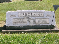
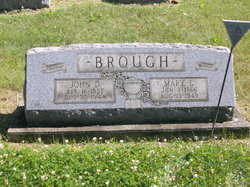
Mary Ellen Nixon Brough
| Birth | : | 3 Jun 1866 Hanover, Harrison County, Ohio, USA |
| Death | : | 13 Aug 1943 Scio, Harrison County, Ohio, USA |
| Burial | : | Grandview Cemetery, Scio, Harrison County, USA |
| Coordinate | : | 40.3903008, -81.0978012 |
| Description | : | The Times Recorder, Zanesville, Ohio, Monday, August 16, 1943~ SCIO, O. - Mrs. Mary Brough, 77, died Friday morning at her home in Scio. She had been a life long resident here and was a member of the Presbyterian church. Funeral rites will be held at 2 o'clock Tuesday at the home with Rev. T. N. Nickelson officiating. |
frequently asked questions (FAQ):
-
Where is Mary Ellen Nixon Brough's memorial?
Mary Ellen Nixon Brough's memorial is located at: Grandview Cemetery, Scio, Harrison County, USA.
-
When did Mary Ellen Nixon Brough death?
Mary Ellen Nixon Brough death on 13 Aug 1943 in Scio, Harrison County, Ohio, USA
-
Where are the coordinates of the Mary Ellen Nixon Brough's memorial?
Latitude: 40.3903008
Longitude: -81.0978012
Family Members:
Parent
Spouse
Siblings
Children
Flowers:
Nearby Cemetories:
1. Grandview Cemetery
Scio, Harrison County, USA
Coordinate: 40.3903008, -81.0978012
2. Methodist Episcopal Church Cemetery
Scio, Harrison County, USA
Coordinate: 40.3970800, -81.0864600
3. Hanover Cemetery
Harrison County, USA
Coordinate: 40.3700600, -81.0670400
4. Wood Cemetery
Scio, Harrison County, USA
Coordinate: 40.4193500, -81.0707690
5. Ridgeview Cemetery
Scio, Harrison County, USA
Coordinate: 40.3620900, -81.0566400
6. Conotton Cemetery
Harrison County, USA
Coordinate: 40.4103012, -81.1489029
7. Mount Hope Cemetery
Tappan, Harrison County, USA
Coordinate: 40.3466400, -81.1237360
8. United Brethren Cemetery
Harrison County, USA
Coordinate: 40.4043999, -81.0353012
9. New Rumley Methodist Cemetery
New Rumley, Harrison County, USA
Coordinate: 40.4028015, -81.0346985
10. Conaway Cemetery
Bowerston, Harrison County, USA
Coordinate: 40.3384420, -81.0889720
11. Evangelical Lutheran Cemetery
New Rumley, Harrison County, USA
Coordinate: 40.4019012, -81.0271988
12. Beaver Valley Cemetery
Monroe Township, Harrison County, USA
Coordinate: 40.3779100, -81.1703860
13. Allen Memorial Cemetery
Carroll County, USA
Coordinate: 40.4364014, -81.0511017
14. Hagey Family Cemetery
Perrysville, Carroll County, USA
Coordinate: 40.4525980, -81.0996160
15. Mount Zion African Methodist Episcopal Cemetery
Conotton, Harrison County, USA
Coordinate: 40.3598990, -81.1733160
16. Swinehart Cemetery
Carroll County, USA
Coordinate: 40.4327000, -81.1642170
17. Mount Olive Cemetery
Carroll County, USA
Coordinate: 40.4488983, -81.1382980
18. New Perrysville Cemetery
Perrysville, Carroll County, USA
Coordinate: 40.4569016, -81.1016998
19. Pleasant Valley Cemetery
Deersville, Harrison County, USA
Coordinate: 40.3307991, -81.1500015
20. Old Pleasant Valley Cemetery (Defunct)
Deersville, Harrison County, USA
Coordinate: 40.3313960, -81.1525640
21. Perrysville United Methodist Cemetery
Perrysville, Carroll County, USA
Coordinate: 40.4625510, -81.0973610
22. Fairview Cemetery
Jewett, Harrison County, USA
Coordinate: 40.3806000, -81.0030975
23. Perrysville Methodist Episcopal Church Cemetery
Perrysville, Carroll County, USA
Coordinate: 40.4655991, -81.0982971
24. Layport Cemetery
Deersville, Harrison County, USA
Coordinate: 40.3265110, -81.1513070

