
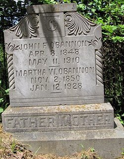
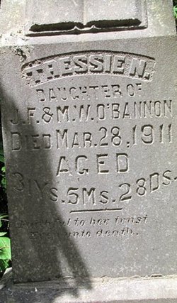
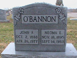
John Frank O'Bannon
| Birth | : | 22 Apr 1849 St. Francois County, Missouri, USA |
| Death | : | 11 May 1910 Knob Lick, St. Francois County, Missouri, USA |
| Burial | : | Topeka Cemetery, Topeka, Shawnee County, USA |
| Coordinate | : | 39.0388985, -95.6528015 |
| Description | : | Word was received here this morning that Mr. John Frank O'Bannon died at his home near Syenite last night at 8 o'clock (May 11, 1910.) Mr. O'Bannon is one of our best known citizens, a man of many excellent traits of character, and has many friends throughout the county who will be sorry to hear of his death. He was the eldest son of William Isom and Martha Hunt O'Bannon; and was born in Liberty township April 8, 1848. On April 22, 1869, he was married to Miss Mattie W. Sloss of Madison county who survives him, together with a... Read More |
frequently asked questions (FAQ):
-
Where is John Frank O'Bannon's memorial?
John Frank O'Bannon's memorial is located at: Topeka Cemetery, Topeka, Shawnee County, USA.
-
When did John Frank O'Bannon death?
John Frank O'Bannon death on 11 May 1910 in Knob Lick, St. Francois County, Missouri, USA
-
Where are the coordinates of the John Frank O'Bannon's memorial?
Latitude: 39.0388985
Longitude: -95.6528015
Family Members:
Spouse

Children

Flowers:


Nearby Cemetories:
1. Topeka Cemetery
Topeka, Shawnee County, USA
Coordinate: 39.0388985, -95.6528015
2. Mount Auburn Cemetery
Topeka, Shawnee County, USA
Coordinate: 39.0393982, -95.6500015
3. Grace Episcopal Cathedral Sanctuary
Topeka, Shawnee County, USA
Coordinate: 39.0506925, -95.6839273
4. Grace Episcopal Cathedral Columbarium
Topeka, Shawnee County, USA
Coordinate: 39.0511284, -95.6843719
5. Carnegie Hall
Topeka, Shawnee County, USA
Coordinate: 39.0350600, -95.6999100
6. Westminster Presbyterian Church Memorial Garden
Topeka, Shawnee County, USA
Coordinate: 39.0430400, -95.7021700
7. Ritchie Cemetery
Topeka, Shawnee County, USA
Coordinate: 39.0228010, -95.7027530
8. Curtis Family Cemetery
North Topeka, Shawnee County, USA
Coordinate: 39.0792870, -95.6702270
9. Topeka State Hospital Cemetery
Topeka, Shawnee County, USA
Coordinate: 39.0671005, -95.7080994
10. Saint Davids Episcopal Church Columbarium
Topeka, Shawnee County, USA
Coordinate: 39.0369860, -95.7259480
11. Memorial Park Cemetery
Topeka, Shawnee County, USA
Coordinate: 39.0619011, -95.7221985
12. Bethel Cemetery
Topeka, Shawnee County, USA
Coordinate: 39.0085983, -95.5864029
13. Foster Cemetery
Topeka, Shawnee County, USA
Coordinate: 38.9942017, -95.7061005
14. Mount Calvary Cemetery
Topeka, Shawnee County, USA
Coordinate: 39.0532990, -95.7360992
15. Mount Hope Cemetery
Topeka, Shawnee County, USA
Coordinate: 39.0367393, -95.7386703
16. Bennie Lee Graham Memorial Cemetery
Shawnee County, USA
Coordinate: 39.1020584, -95.6836472
17. Rochester Cemetery
Topeka, Shawnee County, USA
Coordinate: 39.1044006, -95.6800003
18. Bauer Cemetery
Topeka, Shawnee County, USA
Coordinate: 38.9864006, -95.5764008
19. Old Grantville Cemetery
Grantville, Jefferson County, USA
Coordinate: 39.0949500, -95.5771300
20. Lynn Creek Cemetery
Berryton, Shawnee County, USA
Coordinate: 38.9575005, -95.6408005
21. Grantville Cemetery
Grantville, Jefferson County, USA
Coordinate: 39.0957400, -95.5745800
22. Security Benefit Association Cemetery
Topeka, Shawnee County, USA
Coordinate: 39.0630989, -95.7606583
23. Emmanuel Cemetery
Watson, Shawnee County, USA
Coordinate: 38.9719009, -95.5744019
24. Abram Burnett Burial Site
Topeka, Shawnee County, USA
Coordinate: 39.0102997, -95.7685776