
| Birth | : | 10 May 1865 Holt County, Missouri, USA |
| Death | : | 30 Apr 1928 Omaha, Douglas County, Nebraska, USA |
| Burial | : | Old Woking Burial Ground, Old Woking, Woking Borough, England |
| Coordinate | : | 51.3026230, -0.5351320 |
| Plot | : | Block 9, Lot 46 |
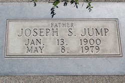
| Inscription | : | Unmarked grave. This name (and spelling) were taken from the cemetery directory. |
| Description | : | After their son Johnnie's death in 1915, Susan and John Jump moved to Montana to be near her daughter, Annie Nora Freel. In 1922, John left home to take a load of cattle to Great Falls, Montana and did not return. In 1927, Susan sold their farm and moved to Thurston County Nebraska to live with her daughter, Frances Cochran. |
frequently asked questions (FAQ):
-
Where is John H Jump's memorial?
John H Jump's memorial is located at: Old Woking Burial Ground, Old Woking, Woking Borough, England.
-
When did John H Jump death?
John H Jump death on 30 Apr 1928 in Omaha, Douglas County, Nebraska, USA
-
Where are the coordinates of the John H Jump's memorial?
Latitude: 51.3026230
Longitude: -0.5351320
Family Members:
Spouse

Children
Flowers:


Nearby Cemetories:
1. Old Woking Burial Ground
Old Woking, Woking Borough, England
Coordinate: 51.3026230, -0.5351320
2. St Peter's Church
Old Woking, Woking Borough, England
Coordinate: 51.3017410, -0.5372560
3. Send Cemetery
Send, Guildford Borough, England
Coordinate: 51.2876880, -0.5273440
4. St. Nicholas Church
Pyrford, Woking Borough, England
Coordinate: 51.3137910, -0.5094020
5. St Mary the Virgin Churchyard
Send, Guildford Borough, England
Coordinate: 51.2791230, -0.5408600
6. St Mary Magdalen Churchyard
Ripley, Guildford Borough, England
Coordinate: 51.2992230, -0.4936400
7. St Mary the Virgin Churchyard
Horsell, Woking Borough, England
Coordinate: 51.3227460, -0.5703770
8. St Edward the Confessor Churchyard
Sutton Green, Woking Borough, England
Coordinate: 51.2741930, -0.5608230
9. St John the Baptist Churchyard
St Johns, Woking Borough, England
Coordinate: 51.3104700, -0.5929170
10. Wisley Church Churchyard
Wisley, Guildford Borough, England
Coordinate: 51.3257400, -0.4847130
11. All Saints Churchyard
Ockham, Guildford Borough, England
Coordinate: 51.2979900, -0.4710800
12. St John the Baptist Church
West Byfleet, Woking Borough, England
Coordinate: 51.3383570, -0.5023990
13. Burpham Churchyard
Guildford, Guildford Borough, England
Coordinate: 51.2622640, -0.5497350
14. Woking Crematorium
Woking, Woking Borough, England
Coordinate: 51.3122590, -0.6022630
15. St Mary Churchyard
Byfleet, Woking Borough, England
Coordinate: 51.3328210, -0.4757360
16. St Mary the Virgin Churchyard
Worplesdon, Guildford Borough, England
Coordinate: 51.2730100, -0.6067360
17. Ss Peter & Paul Church Cemetery
West Clandon, Guildford Borough, England
Coordinate: 51.2517500, -0.5045400
18. St. Peter & St. Paul's Churchyard
West Clandon, Guildford Borough, England
Coordinate: 51.2507990, -0.5053760
19. Stoke New Cemetery
Guildford, Guildford Borough, England
Coordinate: 51.2543900, -0.5824700
20. St John the Evangelist Churchyard
Merrow, Guildford Borough, England
Coordinate: 51.2459770, -0.5271350
21. Christ Church Cemetery
Ottershaw, Runnymede Borough, England
Coordinate: 51.3610140, -0.5353310
22. Stoke Old Cemetery
Guildford, Guildford Borough, England
Coordinate: 51.2522600, -0.5828500
23. Brookwood Cemetery
Brookwood, Woking Borough, England
Coordinate: 51.3013535, -0.6297340
24. St. John's Churchyard
Stoke-next-Guildford, Guildford Borough, England
Coordinate: 51.2470280, -0.5711690