
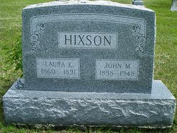
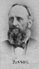
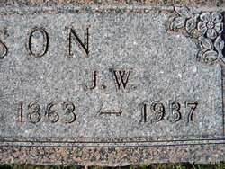
John M. Hixson
| Birth | : | 24 Aug 1858 Lee County, Iowa, USA |
| Death | : | 1948 Centerville, Appanoose County, Iowa, USA |
| Burial | : | Spalding Cemetery, Spalding, South Holland District, England |
| Coordinate | : | 52.7954960, -0.1519390 |
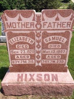
| Description | : | Centerville Daily Iowegian And Citizen, June 12, 1948. John M. Hixon, 89, of 629 W. Van Buren St., passed away Thursday at 12:25 pm at his home. He had been ill for a week before his death. Funeral services will be held at the Miller Funeral Home Sunday at 2:30 pm with the Rev. Luther W. Childs officiating. Burial will be at the Salem Cemetery west of Moravia. He was born in Lee County, Iowa, on August 24, 1858, the son of Samuel and Elizabeth Hixon. He moved, with his family, to Appanoose County at an early age and... Read More |
frequently asked questions (FAQ):
-
Where is John M. Hixson's memorial?
John M. Hixson's memorial is located at: Spalding Cemetery, Spalding, South Holland District, England.
-
When did John M. Hixson death?
John M. Hixson death on 1948 in Centerville, Appanoose County, Iowa, USA
-
Where are the coordinates of the John M. Hixson's memorial?
Latitude: 52.7954960
Longitude: -0.1519390
Family Members:
Parent
Spouse


Siblings
Children
Flowers:


Nearby Cemetories:
1. Spalding Cemetery
Spalding, South Holland District, England
Coordinate: 52.7954960, -0.1519390
2. St Paul's Churchyard
Spalding, South Holland District, England
Coordinate: 52.7969559, -0.1305557
3. St. Mary's Churchyard
Pinchbeck, South Holland District, England
Coordinate: 52.8135340, -0.1589220
4. St. Laurence Churchyard
Surfleet, South Holland District, England
Coordinate: 52.8369500, -0.1436110
5. St Bartholomew's Church West Pinchbeck
Pinchbeck, South Holland District, England
Coordinate: 52.8080873, -0.2216285
6. Surfleet Cemetery
Surfleet, South Holland District, England
Coordinate: 52.8391670, -0.1383330
7. St. Mary's Cemetery
Weston, South Holland District, England
Coordinate: 52.8078662, -0.0809039
8. South Lincolnshire Crematorium
Surfleet, South Holland District, England
Coordinate: 52.8451100, -0.1475110
9. All Saints Churchyard
Moulton, South Holland District, England
Coordinate: 52.7990056, -0.0629691
10. Moulton Cemetery
Moulton, South Holland District, England
Coordinate: 52.8017000, -0.0632400
11. St Gilbert and St Hugh Churchyard
Gosberton Clough, South Holland District, England
Coordinate: 52.8518081, -0.2166268
12. St. Mary's Churchyard
Whaplode, South Holland District, England
Coordinate: 52.7974840, -0.0385520
13. Gosberton Baptist Church
Gosberton, South Holland District, England
Coordinate: 52.8651820, -0.1533940
14. Gosberton Cemetery
Gosberton, South Holland District, England
Coordinate: 52.8659400, -0.1623000
15. St. Peter and St. Paul Churchyard
Gosberton, South Holland District, England
Coordinate: 52.8690870, -0.1629740
16. Whaplode Cemetery
Whaplode, South Holland District, England
Coordinate: 52.8016190, -0.0281347
17. St. Margaret's Churchyard
Quadring, South Holland District, England
Coordinate: 52.8903400, -0.1819700
18. All Saints Churchyard
Holbeach, South Holland District, England
Coordinate: 52.8036140, 0.0142530
19. Holbeach Cemetery
Holbeach, South Holland District, England
Coordinate: 52.8062100, 0.0171500
20. St. John's Churchyard
Holbeach, South Holland District, England
Coordinate: 52.7457510, -0.0024000
21. All Saints Churchyard
Fosdyke, Boston Borough, England
Coordinate: 52.8811100, -0.0469440
22. Fosdyke Village Cemetery
Fosdyke, Boston Borough, England
Coordinate: 52.8808330, -0.0447220
23. Sutterton Village Cemetery
Sutterton, Boston Borough, England
Coordinate: 52.8994440, -0.0900000
24. St. John the Baptist Churchyard
Whaplode Drove, South Holland District, England
Coordinate: 52.7034435, -0.0476688