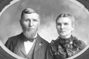
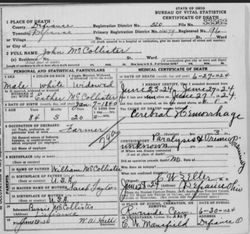
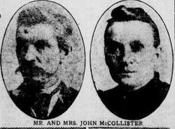
John McCollister
| Birth | : | 7 Jan 1840 Mad River Township, Champaign County, Ohio, USA |
| Death | : | 27 Jun 1924 Defiance, Defiance County, Ohio, USA |
| Burial | : | Mount Calvary Cemetery, Topeka, Shawnee County, USA |
| Coordinate | : | 39.0532990, -95.7360992 |
| Plot | : | Sec 26, Lot 25, Grave 3 |
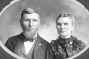
| Description | : | COUNTY PIONEER TAKEN BY DEATH John McCollister, 84, Weds, Lives, Dies In Same Dwelling Death came to John McCollister, 84, at 5:30 last evening at his Defiance township farm home overlooking the valley of Powell's Creek where he had lived 63 years. It was at this same farm on Christmas day in 1860 where he wed Miss Esther Brown, daughter of Joseph and Esther Brown. There their thirteen children were born; there they spent their golden wedding anniversary on Christmas day, 1910; there Mrs. McCollister died in 1914, and from there Mr. McCollister will be buried. Funeral will be at 10 o'clock Monday morning,... Read More |
frequently asked questions (FAQ):
-
Where is John McCollister's memorial?
John McCollister's memorial is located at: Mount Calvary Cemetery, Topeka, Shawnee County, USA.
-
When did John McCollister death?
John McCollister death on 27 Jun 1924 in Defiance, Defiance County, Ohio, USA
-
Where are the coordinates of the John McCollister's memorial?
Latitude: 39.0532990
Longitude: -95.7360992
Family Members:
Parent
Spouse
Siblings
Children
Flowers:
Nearby Cemetories:
1. Mount Calvary Cemetery
Topeka, Shawnee County, USA
Coordinate: 39.0532990, -95.7360992
2. Memorial Park Cemetery
Topeka, Shawnee County, USA
Coordinate: 39.0619011, -95.7221985
3. Mount Hope Cemetery
Topeka, Shawnee County, USA
Coordinate: 39.0367393, -95.7386703
4. Saint Davids Episcopal Church Columbarium
Topeka, Shawnee County, USA
Coordinate: 39.0369860, -95.7259480
5. Security Benefit Association Cemetery
Topeka, Shawnee County, USA
Coordinate: 39.0630989, -95.7606583
6. Topeka State Hospital Cemetery
Topeka, Shawnee County, USA
Coordinate: 39.0671005, -95.7080994
7. Westminster Presbyterian Church Memorial Garden
Topeka, Shawnee County, USA
Coordinate: 39.0430400, -95.7021700
8. Carnegie Hall
Topeka, Shawnee County, USA
Coordinate: 39.0350600, -95.6999100
9. Ritchie Cemetery
Topeka, Shawnee County, USA
Coordinate: 39.0228010, -95.7027530
10. Grace Episcopal Cathedral Columbarium
Topeka, Shawnee County, USA
Coordinate: 39.0511284, -95.6843719
11. Grace Episcopal Cathedral Sanctuary
Topeka, Shawnee County, USA
Coordinate: 39.0506925, -95.6839273
12. Abram Burnett Burial Site
Topeka, Shawnee County, USA
Coordinate: 39.0102997, -95.7685776
13. Mission Center Cemetery
Topeka, Shawnee County, USA
Coordinate: 39.0145493, -95.7819290
14. Prairie Home Cemetery
Topeka, Shawnee County, USA
Coordinate: 39.1077118, -95.7482910
15. Curtis Family Cemetery
North Topeka, Shawnee County, USA
Coordinate: 39.0792870, -95.6702270
16. West Lawn Memorial Gardens
Topeka, Shawnee County, USA
Coordinate: 39.0518112, -95.8167419
17. Bennie Lee Graham Memorial Cemetery
Shawnee County, USA
Coordinate: 39.1020584, -95.6836472
18. Foster Cemetery
Topeka, Shawnee County, USA
Coordinate: 38.9942017, -95.7061005
19. Topeka Cemetery
Topeka, Shawnee County, USA
Coordinate: 39.0388985, -95.6528015
20. Rochester Cemetery
Topeka, Shawnee County, USA
Coordinate: 39.1044006, -95.6800003
21. Mount Auburn Cemetery
Topeka, Shawnee County, USA
Coordinate: 39.0393982, -95.6500015
22. Elevation Cemetery
Shawnee County, USA
Coordinate: 38.9832993, -95.7613983
23. Half-Day Cemetery
Elmont, Shawnee County, USA
Coordinate: 39.1584702, -95.7143402
24. Valencia Cemetery
Valencia, Shawnee County, USA
Coordinate: 39.0586014, -95.8806000

