
| Birth | : | 7 Mar 1927 Spalding, Greeley County, Nebraska, USA |
| Death | : | 6 Jul 2016 Council Bluffs, Pottawattamie County, Iowa, USA |
| Burial | : | Memorial Park Cemetery, Council Bluffs, Pottawattamie County, USA |
| Coordinate | : | 41.2644005, -95.8261032 |
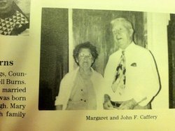
| Description | : | John was born to John F. and Margaret (Palmer) Caffery. He proudly served his country I the United States Army during World War II 1946-1949 and the Korean War 1950-1951. John married Anna R. Petersen on November 10-1951. He worked for the Union Pacific Railroad for over 44 years and was a member of Holy Family Church, American Legion, VFW, Disabled American Veterans and was past president of the UP Oldtimers. Preceded by: Parents: John and Margaret Wife: Anna in 2007 Son in law: Rick McKeeman(2006) Sisters: Lucille Calabretto, Leona Klanecky Brothers: Larry and Leo Caffery Survived by: Daughters: Anna(Pat) Daeges, Nora Lehmer, Wanda McKeeman Grandchildren: Brian, Heather,... Read More |
frequently asked questions (FAQ):
-
Where is John Raymond Caffery's memorial?
John Raymond Caffery's memorial is located at: Memorial Park Cemetery, Council Bluffs, Pottawattamie County, USA.
-
When did John Raymond Caffery death?
John Raymond Caffery death on 6 Jul 2016 in Council Bluffs, Pottawattamie County, Iowa, USA
-
Where are the coordinates of the John Raymond Caffery's memorial?
Latitude: 41.2644005
Longitude: -95.8261032
Family Members:
Parent

Spouse

Siblings
Flowers:


Nearby Cemetories:
1. Memorial Park Cemetery
Council Bluffs, Pottawattamie County, USA
Coordinate: 41.2644005, -95.8261032
2. Ridgewood Cemetery
Council Bluffs, Pottawattamie County, USA
Coordinate: 41.2694016, -95.8272018
3. Oak Hill Cemetery
Council Bluffs, Pottawattamie County, USA
Coordinate: 41.2700900, -95.8226400
4. Bikhor Cholim Cemetery
Council Bluffs, Pottawattamie County, USA
Coordinate: 41.2703670, -95.8229350
5. Walnut Hill Cemetery
Council Bluffs, Pottawattamie County, USA
Coordinate: 41.2719002, -95.8255997
6. Cedar Lawn Cemetery
Council Bluffs, Pottawattamie County, USA
Coordinate: 41.2694016, -95.8182983
7. Saint Joseph Cemetery
Council Bluffs, Pottawattamie County, USA
Coordinate: 41.2722015, -95.8208008
8. Clark Cemetery
Pottawattamie County, USA
Coordinate: 41.2551610, -95.8223390
9. Green Valley Cemetery
Council Bluffs, Pottawattamie County, USA
Coordinate: 41.2743988, -95.8225021
10. Fairview Cemetery
Council Bluffs, Pottawattamie County, USA
Coordinate: 41.2703018, -95.8480988
11. Garner Cemetery
Council Bluffs, Pottawattamie County, USA
Coordinate: 41.2956161, -95.8001709
12. Maple Grove Cemetery
Council Bluffs, Pottawattamie County, USA
Coordinate: 41.2265560, -95.8187100
13. Stoker-Graybill Cemetery
Council Bluffs, Pottawattamie County, USA
Coordinate: 41.2532620, -95.7751770
14. Lewis Township Cemetery
Council Bluffs, Pottawattamie County, USA
Coordinate: 41.2117004, -95.7938995
15. Evans Cemetery
Crescent, Pottawattamie County, USA
Coordinate: 41.3255997, -95.8368988
16. Council Point Cemetery
Council Bluffs, Pottawattamie County, USA
Coordinate: 41.2110830, -95.8788610
17. Gregg Cemetery
Weston, Pottawattamie County, USA
Coordinate: 41.3330000, -95.7931000
18. Trinity Cathedral Columbarium
Omaha, Douglas County, USA
Coordinate: 41.2603900, -95.9393660
19. Hazel Dell Cemetery
Council Bluffs, Pottawattamie County, USA
Coordinate: 41.3489723, -95.7939911
20. Saint Columbanus Cemetery
Weston, Pottawattamie County, USA
Coordinate: 41.3429440, -95.7435260
21. Prospect Hill Cemetery
Omaha, Douglas County, USA
Coordinate: 41.2780991, -95.9593964
22. Crescent Cemetery
Crescent, Pottawattamie County, USA
Coordinate: 41.3664894, -95.8566208
23. First Central Congregational Columbarium
Omaha, Douglas County, USA
Coordinate: 41.2563456, -95.9658365
24. Saint Pauls Evangelical Country Church Cemetery
Dumfries, Pottawattamie County, USA
Coordinate: 41.1748352, -95.7492371