
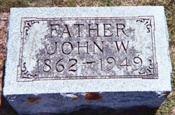


John William Marker
| Birth | : | 10 Oct 1862 Rochelle, Ogle County, Illinois, USA |
| Death | : | 15 Oct 1949 Rockford, Floyd County, Iowa, USA |
| Burial | : | Ss Mary and Clement Churchyard, Clavering, Uttlesford District, England |
| Coordinate | : | 51.9653720, 0.1393760 |
| Plot | : | Section 2 |
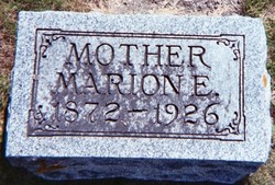
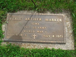
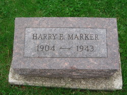
| Description | : | John was the son of Reuben and Louisa Blair Marker. Her married Marion Harrison on Dec 23, 1891. She died injuries received in a car/train accident on Oct 31, 1926. John and Marion had seven children, Clarence, Clara, Verle, Wilbur, Mabel, Harry and John. |
frequently asked questions (FAQ):
-
Where is John William Marker's memorial?
John William Marker's memorial is located at: Ss Mary and Clement Churchyard, Clavering, Uttlesford District, England.
-
When did John William Marker death?
John William Marker death on 15 Oct 1949 in Rockford, Floyd County, Iowa, USA
-
Where are the coordinates of the John William Marker's memorial?
Latitude: 51.9653720
Longitude: 0.1393760
Family Members:
Parent
Spouse
Siblings
Children

Flowers:


Nearby Cemetories:
1. Ss Mary and Clement Churchyard
Clavering, Uttlesford District, England
Coordinate: 51.9653720, 0.1393760
2. All Saints Churchyard
Rickling, Uttlesford District, England
Coordinate: 51.9615100, 0.1798200
3. St Margaret Churchyard
Arkesden, Uttlesford District, England
Coordinate: 51.9897000, 0.1571200
4. Saint Mary Churchyard
Meesden, East Hertfordshire District, England
Coordinate: 51.9728000, 0.0934270
5. St. John The Evangelist Churchyard
Langley, Uttlesford District, England
Coordinate: 51.9969356, 0.0995640
6. Quendon Churchyard
Quendon, Uttlesford District, England
Coordinate: 51.9535800, 0.2038700
7. St Mary the Virgin Churchyard
Furneux Pelham, East Hertfordshire District, England
Coordinate: 51.9316710, 0.0808950
8. St Mary the Virgin Churchyard
Newport, Uttlesford District, England
Coordinate: 51.9845000, 0.2135600
9. The Hamlet Church Cemetery
Duddenhoe End, Uttlesford District, England
Coordinate: 52.0145269, 0.1285385
10. St Peter Churchyard
Ugley, Uttlesford District, England
Coordinate: 51.9364900, 0.2086500
11. St. Mary the Virgin Churchyard
Wendens Ambo, Uttlesford District, England
Coordinate: 52.0049490, 0.2029250
12. St George Churchyard
Anstey, East Hertfordshire District, England
Coordinate: 51.9766990, 0.0431300
13. St Mary the Virgin Churchyard
Widdington, Uttlesford District, England
Coordinate: 51.9629600, 0.2397600
14. St. Mary the Virgin Churchyard
Farnham, Uttlesford District, England
Coordinate: 51.9020340, 0.1517660
15. Holy Trinity Churchyard
Chrishall, Uttlesford District, England
Coordinate: 52.0276500, 0.1139577
16. Great Hormead St Nicholas Churchyard
Hormead, East Hertfordshire District, England
Coordinate: 51.9469500, 0.0353300
17. St Nicholas Churchyard
Little Chishill, South Cambridgeshire District, England
Coordinate: 52.0154690, 0.0654890
18. Little Hormead St Mary Churchyard
Hormead, East Hertfordshire District, England
Coordinate: 51.9428430, 0.0331630
19. St. Nicholas Churchyard
Elmdon, Uttlesford District, England
Coordinate: 52.0359900, 0.1294000
20. St Mary's Churchyard
Albury, East Hertfordshire District, England
Coordinate: 51.9026500, 0.0852920
21. St Mary the Virgin Churchyard
Henham, Uttlesford District, England
Coordinate: 51.9342500, 0.2456300
22. St Mary the Virgin and All Saints Churchyard
Debden, Uttlesford District, England
Coordinate: 51.9759030, 0.2568160
23. Hare Street Benson Grounds
Buntingford, East Hertfordshire District, England
Coordinate: 51.9492640, 0.0221120
24. St Swithin Churchyard
Great Chishill, South Cambridgeshire District, England
Coordinate: 52.0300090, 0.0715990