
| Birth | : | 6 Nov 1922 Ellsworth, Nobles County, Minnesota, USA |
| Death | : | 11 Feb 2006 Council Bluffs, Pottawattamie County, Iowa, USA |
| Burial | : | Branson Cemetery, Loveland, Pottawattamie County, USA |
| Coordinate | : | 41.4846992, -95.8606033 |
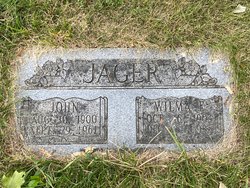
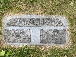
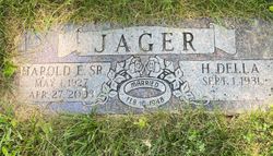
| Inscription | : | Johnny LeRoy Jager Sr US Army Air Forces World War II Nov 6 1922 + Feb 11 2006 JAGER Johnny L. Sr. Nov. 6, 1922 Feb. 11, 2006 Married Mar. 16, 1943 Lillian M. Jan. |
| Description | : | Obituary taken from Council Bluffs Nonpareil: February 13, 2006 Johnny L. Jager Sr. age 83, of Council Bluffs, passed away February 11, 2006, at his home after an extended illness. Johnny was born in Ellsworth, Minn., to the late John and Wilma (Hall) Jager on November 6, 1922. Johnny moved to Council Bluffs in 1924. He served in the Army Air Corps during WWII. Johnny was a coach cleaner for the Union Pacific Railroad for 25 years and later worked for the City of Council Bluffs as a truck driver for 17 years. He retired in 1986. He... Read More |
frequently asked questions (FAQ):
-
Where is Johnny LeRoy Jager Sr.'s memorial?
Johnny LeRoy Jager Sr.'s memorial is located at: Branson Cemetery, Loveland, Pottawattamie County, USA.
-
When did Johnny LeRoy Jager Sr. death?
Johnny LeRoy Jager Sr. death on 11 Feb 2006 in Council Bluffs, Pottawattamie County, Iowa, USA
-
Where are the coordinates of the Johnny LeRoy Jager Sr.'s memorial?
Latitude: 41.4846992
Longitude: -95.8606033
Family Members:
Parent
Spouse

Siblings
Children
Flowers:


Nearby Cemetories:
1. Branson Cemetery
Loveland, Pottawattamie County, USA
Coordinate: 41.4846992, -95.8606033
2. Crook Cemetery
Honey Creek, Pottawattamie County, USA
Coordinate: 41.4581330, -95.8737000
3. Saint Bridgets Cemetery
Honey Creek, Pottawattamie County, USA
Coordinate: 41.4664001, -95.8289032
4. Oak Grove Cemetery
Missouri Valley, Harrison County, USA
Coordinate: 41.5167007, -95.8649979
5. Allen Cemetery
Pottawattamie County, USA
Coordinate: 41.4427986, -95.8550034
6. Grange Cemetery
Honey Creek, Pottawattamie County, USA
Coordinate: 41.4446678, -95.8034668
7. Reels Cemetery
Crescent, Pottawattamie County, USA
Coordinate: 41.4234100, -95.8321700
8. William C McIntosh Cemetery
Crescent, Pottawattamie County, USA
Coordinate: 41.4088745, -95.8477097
9. Rose Hill Memorial Gardens
Missouri Valley, Harrison County, USA
Coordinate: 41.5656000, -95.8897000
10. Hurleys Evergreen Cemetery
Harrison County, USA
Coordinate: 41.5700989, -95.8618698
11. Mount Carmel Cemetery
Missouri Valley, Harrison County, USA
Coordinate: 41.5675011, -95.8897018
12. Saint Pauls Lutheran Cemetery
Neola, Pottawattamie County, USA
Coordinate: 41.4337000, -95.7607000
13. Champan Frazier Cemetery
Harrison County, USA
Coordinate: 41.5773500, -95.8933500
14. Frazier Cemetery
Missouri Valley, Harrison County, USA
Coordinate: 41.5932999, -95.8375015
15. Linnwood Cemetery
Harrison County, USA
Coordinate: 41.5589200, -95.7502100
16. Crescent Cemetery
Crescent, Pottawattamie County, USA
Coordinate: 41.3664894, -95.8566208
17. Shipley Cemetery
Washington County, USA
Coordinate: 41.3932991, -95.9828033
18. Fort Calhoun Cemetery
Fort Calhoun, Washington County, USA
Coordinate: 41.4581375, -96.0352020
19. Harris Grove Cemetery
Beebeetown, Harrison County, USA
Coordinate: 41.5782928, -95.7262192
20. Hazel Dell Cemetery
Council Bluffs, Pottawattamie County, USA
Coordinate: 41.3489723, -95.7939911
21. Castor Cemetery
Underwood, Pottawattamie County, USA
Coordinate: 41.4127040, -95.6887490
22. Calhoun Cemetery
Calhoun, Harrison County, USA
Coordinate: 41.6391983, -95.8938980
23. Gregg Cemetery
Weston, Pottawattamie County, USA
Coordinate: 41.3330000, -95.7931000
24. Evans Cemetery
Crescent, Pottawattamie County, USA
Coordinate: 41.3255997, -95.8368988