
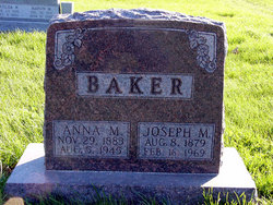
Joseph Marion Baker
| Birth | : | 8 Aug 1879 Clarke County, Iowa, USA |
| Death | : | 16 Feb 1969 Osceola, Clarke County, Iowa, USA |
| Burial | : | Hazel Dell Cemetery, Council Bluffs, Pottawattamie County, USA |
| Coordinate | : | 41.3489723, -95.7939911 |
| Description | : | Joseph Marion Baker, son of Samuel Baker and Lettice Ann VanMeter Harrison Baker, was born in Clarke county, Iowa, on August 8, 1979, and completed this life on February 16, 1969, at the Clarke County Public Hospital. He received his formal education in the schools of this county. On March 8, 1904, he was united in marriage to Anna Melvina Clouse in Lucas county, Iowa. Five children were born to them. He operated grocery stores for many years but most of his life he was a farmer and resided in Clarke county. He was affiliated with the United Methodist Church. Joe was preceded... Read More |
frequently asked questions (FAQ):
-
Where is Joseph Marion Baker's memorial?
Joseph Marion Baker's memorial is located at: Hazel Dell Cemetery, Council Bluffs, Pottawattamie County, USA.
-
When did Joseph Marion Baker death?
Joseph Marion Baker death on 16 Feb 1969 in Osceola, Clarke County, Iowa, USA
-
Where are the coordinates of the Joseph Marion Baker's memorial?
Latitude: 41.3489723
Longitude: -95.7939911
Family Members:
Parent

Spouse

Siblings

Children
Flowers:


Nearby Cemetories:
1. Hazel Dell Cemetery
Council Bluffs, Pottawattamie County, USA
Coordinate: 41.3489723, -95.7939911
2. Gregg Cemetery
Weston, Pottawattamie County, USA
Coordinate: 41.3330000, -95.7931000
3. Saint Columbanus Cemetery
Weston, Pottawattamie County, USA
Coordinate: 41.3429440, -95.7435260
4. Evans Cemetery
Crescent, Pottawattamie County, USA
Coordinate: 41.3255997, -95.8368988
5. Crescent Cemetery
Crescent, Pottawattamie County, USA
Coordinate: 41.3664894, -95.8566208
6. Garner Cemetery
Council Bluffs, Pottawattamie County, USA
Coordinate: 41.2956161, -95.8001709
7. Downsville Cemetery
Pottawattamie County, USA
Coordinate: 41.3502998, -95.7039032
8. William C McIntosh Cemetery
Crescent, Pottawattamie County, USA
Coordinate: 41.4088745, -95.8477097
9. Green Valley Cemetery
Council Bluffs, Pottawattamie County, USA
Coordinate: 41.2743988, -95.8225021
10. Saint Joseph Cemetery
Council Bluffs, Pottawattamie County, USA
Coordinate: 41.2722015, -95.8208008
11. Reels Cemetery
Crescent, Pottawattamie County, USA
Coordinate: 41.4234100, -95.8321700
12. Walnut Hill Cemetery
Council Bluffs, Pottawattamie County, USA
Coordinate: 41.2719002, -95.8255997
13. Bikhor Cholim Cemetery
Council Bluffs, Pottawattamie County, USA
Coordinate: 41.2703670, -95.8229350
14. Cedar Lawn Cemetery
Council Bluffs, Pottawattamie County, USA
Coordinate: 41.2694016, -95.8182983
15. Oak Hill Cemetery
Council Bluffs, Pottawattamie County, USA
Coordinate: 41.2700900, -95.8226400
16. Ridgewood Cemetery
Council Bluffs, Pottawattamie County, USA
Coordinate: 41.2694016, -95.8272018
17. H G Fisher Cemetery
Underwood, Pottawattamie County, USA
Coordinate: 41.3838997, -95.6889038
18. Memorial Park Cemetery
Council Bluffs, Pottawattamie County, USA
Coordinate: 41.2644005, -95.8261032
19. Saint Pauls Lutheran Cemetery
Neola, Pottawattamie County, USA
Coordinate: 41.4337000, -95.7607000
20. Fairview Cemetery
Council Bluffs, Pottawattamie County, USA
Coordinate: 41.2703018, -95.8480988
21. Grange Cemetery
Honey Creek, Pottawattamie County, USA
Coordinate: 41.4446678, -95.8034668
22. Clark Cemetery
Pottawattamie County, USA
Coordinate: 41.2551610, -95.8223390
23. Pottawattamie County Home Cemetery
McClelland, Pottawattamie County, USA
Coordinate: 41.3269400, -95.6691738
24. Stoker-Graybill Cemetery
Council Bluffs, Pottawattamie County, USA
Coordinate: 41.2532620, -95.7751770