
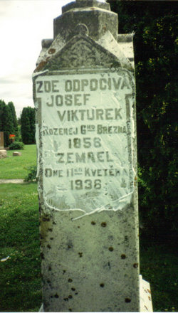
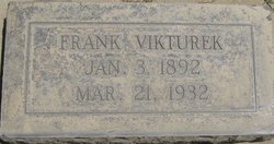
Joseph Vikturek
| Birth | : | 6 Mar 1858 Jihočeský (South Bohemia), Czech Republic |
| Death | : | 11 May 1936 Plymouth, Cerro Gordo County, Iowa, USA |
| Burial | : | St Thomas Churchyard, Ryde, Isle of Wight Unitary Authority, England |
| Coordinate | : | 50.7305600, -1.1632540 |
| Plot | : | SW quadrant, Block 4, Lot 19 |
| Description | : | The following is a transcript of his birth/baptism record from parish book Jílovice 4, page 12 located in Trebon: born on the 6th and baptized on the 7th March 1858 in Lipnice House No. 5 /catholic, male, legitimate/ /parish book Jílovice 4, page 12/ /record written in Czech/ Father: Matej Vikturek, farmer son of František Vikturek, farmer in Slabošovice (Slavošovice) House No. 5, region Budejovice (Ceské Budejovice), and of his wife Katerina nee Hešíková from Libín House No. 5, district Trebon Mother: Anna, daughter of deceased Josef Jezvík, farmer from Lipnice House No. 5, and of his wife... Read More |
frequently asked questions (FAQ):
-
Where is Joseph Vikturek's memorial?
Joseph Vikturek's memorial is located at: St Thomas Churchyard, Ryde, Isle of Wight Unitary Authority, England.
-
When did Joseph Vikturek death?
Joseph Vikturek death on 11 May 1936 in Plymouth, Cerro Gordo County, Iowa, USA
-
Where are the coordinates of the Joseph Vikturek's memorial?
Latitude: 50.7305600
Longitude: -1.1632540
Family Members:
Spouse
Children

Flowers:


Nearby Cemetories:
1. St Thomas Churchyard
Ryde, Isle of Wight Unitary Authority, England
Coordinate: 50.7305600, -1.1632540
2. Ryde Cemetery
Ryde, Isle of Wight Unitary Authority, England
Coordinate: 50.7249730, -1.1668550
3. St Cecilia's Abbey
Ryde, Isle of Wight Unitary Authority, England
Coordinate: 50.7279800, -1.1463120
4. Holy Cross Churchyard
Binstead, Isle of Wight Unitary Authority, England
Coordinate: 50.7320080, -1.1863070
5. Binstead Cemetery
Binstead, Isle of Wight Unitary Authority, England
Coordinate: 50.7264610, -1.1866180
6. St. Johns Churchyard
Ryde, Isle of Wight Unitary Authority, England
Coordinate: 50.7149770, -1.1482370
7. Quarr Old Abbey
Ryde, Isle of Wight Unitary Authority, England
Coordinate: 50.7310000, -1.1996000
8. Quarr Abbey
Binstead, Isle of Wight Unitary Authority, England
Coordinate: 50.7311862, -1.2034333
9. St Peter's
Havenstreet, Isle of Wight Unitary Authority, England
Coordinate: 50.7095580, -1.2063290
10. St. Edmund's Churchyard
Wootton, Isle of Wight Unitary Authority, England
Coordinate: 50.7308220, -1.2344490
11. St Mary the Virgin Churchyard
Brading, Isle of Wight Unitary Authority, England
Coordinate: 50.6824400, -1.1429600
12. St. Mark's Churchyard
Alverstoke, Gosport Borough, England
Coordinate: 50.7826800, -1.1436100
13. Clayhall Naval Cemetery
Gosport, Gosport Borough, England
Coordinate: 50.7833862, -1.1373420
14. Turkish Naval Cemetery
Gosport, Gosport Borough, England
Coordinate: 50.7840710, -1.1383980
15. St Mary Churchyard
Alverstoke, Gosport Borough, England
Coordinate: 50.7856760, -1.1480810
16. Isle of Wight Crematorium
Whippingham, Isle of Wight Unitary Authority, England
Coordinate: 50.7217910, -1.2573910
17. Portsmouth Naval Memorial
Portsmouth, Portsmouth Unitary Authority, England
Coordinate: 50.7824440, -1.0957720
18. Ann's Hill Cemetery
Gosport, Gosport Borough, England
Coordinate: 50.7982670, -1.1549450
19. Holy Trinity Churchyard
Gosport, Gosport Borough, England
Coordinate: 50.7930600, -1.1207620
20. Lane End Cemetery
Bembridge, Isle of Wight Unitary Authority, England
Coordinate: 50.6863554, -1.0809575
21. Royal Garrison Church Churchyard
Plymouth, Plymouth Unitary Authority, England
Coordinate: 50.7889690, -1.1039650
22. Royal Garrison Churchyard
Portsmouth, Portsmouth Unitary Authority, England
Coordinate: 50.7890180, -1.1040520
23. Portsmouth Cathedral Churchyard
Portsmouth, Portsmouth Unitary Authority, England
Coordinate: 50.7904650, -1.1043720
24. St John the Evangelist Churchyard
Gosport, Gosport Borough, England
Coordinate: 50.7995600, -1.1397800