
| Birth | : | 11 Sep 1853 Pottawattamie County, Iowa, USA |
| Death | : | 24 Feb 1932 Underwood, Pottawattamie County, Iowa, USA |
| Burial | : | H G Fisher Cemetery, Underwood, Pottawattamie County, USA |
| Coordinate | : | 41.3838997, -95.6889038 |
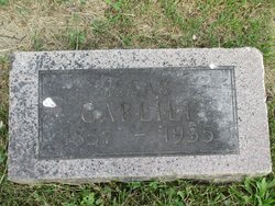
| Description | : | Son of Isaac & Jane; Husband of Lavina Josephine "Josie"; Father of Earl Henry Carlile - Obituary from The Saint's Herald, 6 April 1932: Carlile - Joshua Carlile was born in Council Bluffs, Iowa, September 11, 1853. He spent his entire life in Pottawattamie County living at or near Underwood about fifty-five years. He was married to Josephine Brown by Robert M. Elvin in Council Bluffs March 18, 1882. To them was born one son, Earl H. Carlile of Council Bluffs. Mr. Carlile was baptized into the church by Robert M. Elvin May 18, 1879... Read More |
frequently asked questions (FAQ):
-
Where is Joshua Carlile's memorial?
Joshua Carlile's memorial is located at: H G Fisher Cemetery, Underwood, Pottawattamie County, USA.
-
When did Joshua Carlile death?
Joshua Carlile death on 24 Feb 1932 in Underwood, Pottawattamie County, Iowa, USA
-
Where are the coordinates of the Joshua Carlile's memorial?
Latitude: 41.3838997
Longitude: -95.6889038
Family Members:
Parent

Spouse
Siblings
Children
Flowers:


Nearby Cemetories:
1. H G Fisher Cemetery
Underwood, Pottawattamie County, USA
Coordinate: 41.3838997, -95.6889038
2. Castor Cemetery
Underwood, Pottawattamie County, USA
Coordinate: 41.4127040, -95.6887490
3. Downsville Cemetery
Pottawattamie County, USA
Coordinate: 41.3502998, -95.7039032
4. Saint Columbanus Cemetery
Weston, Pottawattamie County, USA
Coordinate: 41.3429440, -95.7435260
5. Pottawattamie County Home Cemetery
McClelland, Pottawattamie County, USA
Coordinate: 41.3269400, -95.6691738
6. Saint Pauls Lutheran Cemetery
Neola, Pottawattamie County, USA
Coordinate: 41.4337000, -95.7607000
7. Jones - Williams Cemetery
Pottawattamie County, USA
Coordinate: 41.3761000, -95.5846000
8. Hazel Dell Cemetery
Council Bluffs, Pottawattamie County, USA
Coordinate: 41.3489723, -95.7939911
9. Saint Patricks Cemetery
Neola, Pottawattamie County, USA
Coordinate: 41.4581300, -95.6183600
10. Neola Township Cemetery
Neola, Pottawattamie County, USA
Coordinate: 41.4591400, -95.6183800
11. Hardin Township Cemetery
McClelland, Pottawattamie County, USA
Coordinate: 41.2949982, -95.6513977
12. Gregg Cemetery
Weston, Pottawattamie County, USA
Coordinate: 41.3330000, -95.7931000
13. Grange Cemetery
Honey Creek, Pottawattamie County, USA
Coordinate: 41.4446678, -95.8034668
14. Reels Cemetery
Crescent, Pottawattamie County, USA
Coordinate: 41.4234100, -95.8321700
15. Garner Cemetery
Council Bluffs, Pottawattamie County, USA
Coordinate: 41.2956161, -95.8001709
16. William C McIntosh Cemetery
Crescent, Pottawattamie County, USA
Coordinate: 41.4088745, -95.8477097
17. Evans Cemetery
Crescent, Pottawattamie County, USA
Coordinate: 41.3255997, -95.8368988
18. Crescent Cemetery
Crescent, Pottawattamie County, USA
Coordinate: 41.3664894, -95.8566208
19. Saint Bridgets Cemetery
Honey Creek, Pottawattamie County, USA
Coordinate: 41.4664001, -95.8289032
20. Allen Cemetery
Pottawattamie County, USA
Coordinate: 41.4427986, -95.8550034
21. Minden Township Cemetery
Minden, Pottawattamie County, USA
Coordinate: 41.4763908, -95.5444412
22. Fairview Pioneer Cemetery
Treynor, Pottawattamie County, USA
Coordinate: 41.2812843, -95.5555267
23. Silver Valley Cemetery
Hancock, Pottawattamie County, USA
Coordinate: 41.4042015, -95.4969025
24. Stoker-Graybill Cemetery
Council Bluffs, Pottawattamie County, USA
Coordinate: 41.2532620, -95.7751770