
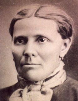
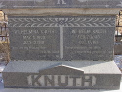
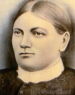
Justine Pauline Friedriche “Wilhelmina” Totz Knuth
| Birth | : | 5 May 1833 Germany |
| Death | : | 13 Jul 1919 Custer County, Colorado, USA |
| Burial | : | St Andrew Churchyard, Stogursey, West Somerset District, England |
| Coordinate | : | 51.1795900, -3.1392800 |
| Plot | : | Lot 69 Block I |
| Description | : | Wet Mountain Tribune Westcliffe, Colorado July 18, 1919 Death's Harvest Mrs. Wilhelmina Knuth passed away at her home in this city on Sunday last, aged 86 years, 2 months and 8 days. Deceased was born in West Prussia, Germany. In 1847 she was married to William Knuth, who died here in 1911. For eight years they resided in Germany then emigrated to America, settling in Chicago, where they endured many hardships for a time, but soon all went well. In 1870 they emigrated with the Wulsten colony and settled in this valley where they made their home ever after. Upon arrival here their hardships were... Read More |
frequently asked questions (FAQ):
-
Where is Justine Pauline Friedriche “Wilhelmina” Totz Knuth's memorial?
Justine Pauline Friedriche “Wilhelmina” Totz Knuth's memorial is located at: St Andrew Churchyard, Stogursey, West Somerset District, England.
-
When did Justine Pauline Friedriche “Wilhelmina” Totz Knuth death?
Justine Pauline Friedriche “Wilhelmina” Totz Knuth death on 13 Jul 1919 in Custer County, Colorado, USA
-
Where are the coordinates of the Justine Pauline Friedriche “Wilhelmina” Totz Knuth's memorial?
Latitude: 51.1795900
Longitude: -3.1392800
Family Members:
Spouse
Children

Flowers:


Nearby Cemetories:
1. St Andrew Churchyard
Stogursey, West Somerset District, England
Coordinate: 51.1795900, -3.1392800
2. Stogursey Extension Cemetery
Stogursey, West Somerset District, England
Coordinate: 51.1793740, -3.1398040
3. Burton Baptist Chapel
Stogursey, West Somerset District, England
Coordinate: 51.1910560, -3.1560340
4. St. Martin's Churchyard
Fiddington, Sedgemoor District, England
Coordinate: 51.1591640, -3.1229530
5. St. Mary's Churchyard
Stringston, West Somerset District, England
Coordinate: 51.1748960, -3.1795460
6. St. Mary's Churchyard
Nether Stowey, Sedgemoor District, England
Coordinate: 51.1502280, -3.1494270
7. Nether Stowey Cemetery
Nether Stowey, Sedgemoor District, England
Coordinate: 51.1498667, -3.1530087
8. St.Mary Magdalene
Stockland Bristol, Sedgemoor District, England
Coordinate: 51.1867260, -3.0886950
9. All Saints Churchyard
Dodington, West Somerset District, England
Coordinate: 51.1583770, -3.1854620
10. St. Nicholas's Churchyard
Holford, West Somerset District, England
Coordinate: 51.1902700, -3.1949170
11. All Saints Churchyard
Otterhampton, Sedgemoor District, England
Coordinate: 51.1829540, -3.0796420
12. Otterhampton Extension Cemetery
Otterhampton, Sedgemoor District, England
Coordinate: 51.1828490, -3.0791630
13. St. Andrew's Churchyard
Lilstock, West Somerset District, England
Coordinate: 51.1971070, -3.1936420
14. Over Stowey Cemetery
Over Stowey, Sedgemoor District, England
Coordinate: 51.1404020, -3.1661850
15. St Peter and St Paul Churchyard
Over Stowey, Sedgemoor District, England
Coordinate: 51.1399680, -3.1656040
16. St. Mary's Churchyard
Holford, West Somerset District, England
Coordinate: 51.1627900, -3.2074238
17. Cannington Cemetery
Cannington, Sedgemoor District, England
Coordinate: 51.1500620, -3.0697070
18. St Mary's Churchyard
Kilve, West Somerset District, England
Coordinate: 51.1883100, -3.2223530
19. Charlynch Church of Saint Mary
Spaxton, Sedgemoor District, England
Coordinate: 51.1342600, -3.0879100
20. Saint Margaret's Churchyard
Spaxton, Sedgemoor District, England
Coordinate: 51.1273090, -3.1087000
21. Spaxton Extension Cemetery
Spaxton, Sedgemoor District, England
Coordinate: 51.1267650, -3.1082920
22. Blessed Virgin Mary Churchyard
Cannington, Sedgemoor District, England
Coordinate: 51.1500970, -3.0622850
23. St. Mary's Churchyard
East Quantoxhead, West Somerset District, England
Coordinate: 51.1855220, -3.2370690
24. All Saints Churchyard
Aisholt, Sedgemoor District, England
Coordinate: 51.1142070, -3.1532890