
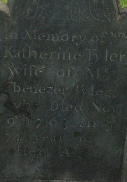
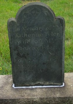
Katherine Bragg Tyler
| Birth | : | 1689 Mendon, Worcester County, Massachusetts, USA |
| Death | : | 9 Nov 1763 Attleboro, Bristol County, Massachusetts, USA |
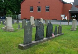
| Burial | : | St Thomas Churchyard, Osbaldwick, York Unitary Authority, England |
| Coordinate | : | 53.9588640, -1.0338800 |
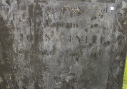
| Inscription | : | In the 74th year of her age |
| Description | : | Wife of Ebenezer Tyler. |
frequently asked questions (FAQ):
-
Where is Katherine Bragg Tyler's memorial?
Katherine Bragg Tyler's memorial is located at: St Thomas Churchyard, Osbaldwick, York Unitary Authority, England.
-
When did Katherine Bragg Tyler death?
Katherine Bragg Tyler death on 9 Nov 1763 in Attleboro, Bristol County, Massachusetts, USA
-
Where are the coordinates of the Katherine Bragg Tyler's memorial?
Latitude: 53.9588640
Longitude: -1.0338800
Family Members:
Spouse
Children

Flowers:


Nearby Cemetories:
1. St Thomas Churchyard
Osbaldwick, York Unitary Authority, England
Coordinate: 53.9588640, -1.0338800
2. St Paul Churchyard
Heslington, York Unitary Authority, England
Coordinate: 53.9471780, -1.0445150
3. Saint James Churchyard
Murton, York Unitary Authority, England
Coordinate: 53.9656390, -1.0125031
4. Holy Trinity Churchyard
Heworth, York Unitary Authority, England
Coordinate: 53.9660080, -1.0596980
5. St Edward's-without-Walmgate (Defunct)
York, York Unitary Authority, England
Coordinate: 53.9547280, -1.0657383
6. Friends Burial Ground
York, York Unitary Authority, England
Coordinate: 53.9478920, -1.0618450
7. St. Lawrence's Churchyard
York, York Unitary Authority, England
Coordinate: 53.9540530, -1.0688730
8. St Margaret Churchyard
York, York Unitary Authority, England
Coordinate: 53.9565370, -1.0729530
9. York Cemetery
York, York Unitary Authority, England
Coordinate: 53.9503960, -1.0723530
10. St Cuthbert Churchyard
York, York Unitary Authority, England
Coordinate: 53.9609180, -1.0752310
11. All Saints Peasholme (Defunct)
York, York Unitary Authority, England
Coordinate: 53.9597200, -1.0759220
12. St John Churchyard
York, York Unitary Authority, England
Coordinate: 53.9591850, -1.0761680
13. St George Churchyard
York, York Unitary Authority, England
Coordinate: 53.9548420, -1.0757670
14. St Denys Churchyard
York, York Unitary Authority, England
Coordinate: 53.9567080, -1.0762240
15. St Crux Hungate Burial Ground
York, York Unitary Authority, England
Coordinate: 53.9593540, -1.0774470
16. St Helen Churchyard
York, York Unitary Authority, England
Coordinate: 53.9509330, -1.0753630
17. York Unitarian Chapelyard
York, York Unitary Authority, England
Coordinate: 53.9602950, -1.0775710
18. St Saviour Churchyard
York, York Unitary Authority, England
Coordinate: 53.9596100, -1.0780000
19. St Andrew Churchyard
York, York Unitary Authority, England
Coordinate: 53.9609180, -1.0784710
20. York Castle Prison Cemetery
York, York Unitary Authority, England
Coordinate: 53.9551950, -1.0782660
21. Central Methodist Hall
York, York Unitary Authority, England
Coordinate: 53.9594090, -1.0788330
22. St Maurice Churchyard
York, York Unitary Authority, England
Coordinate: 53.9633340, -1.0782010
23. New Lane Cemetery
Huntington, York Unitary Authority, England
Coordinate: 53.9816223, -1.0576156
24. St Crux Churchyard
York, York Unitary Authority, England
Coordinate: 53.9589890, -1.0795460