
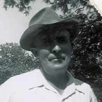
| Birth | : | 18 Nov 1929 |
| Death | : | 5 Nov 2006 |
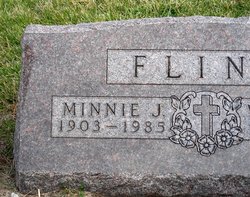
| Burial | : | Lewis Township Cemetery, Council Bluffs, Pottawattamie County, USA |
| Coordinate | : | 41.2117004, -95.7938995 |
frequently asked questions (FAQ):
-
Where is Kenneth Leeroy Flint's memorial?
Kenneth Leeroy Flint's memorial is located at: Lewis Township Cemetery, Council Bluffs, Pottawattamie County, USA.
-
When did Kenneth Leeroy Flint death?
Kenneth Leeroy Flint death on 5 Nov 2006 in
-
Where are the coordinates of the Kenneth Leeroy Flint's memorial?
Latitude: 41.2117004
Longitude: -95.7938995
Family Members:
Parent
Spouse

Siblings
Flowers:


Nearby Cemetories:
1. Lewis Township Cemetery
Council Bluffs, Pottawattamie County, USA
Coordinate: 41.2117004, -95.7938995
2. Maple Grove Cemetery
Council Bluffs, Pottawattamie County, USA
Coordinate: 41.2265560, -95.8187100
3. Stoker-Graybill Cemetery
Council Bluffs, Pottawattamie County, USA
Coordinate: 41.2532620, -95.7751770
4. Clark Cemetery
Pottawattamie County, USA
Coordinate: 41.2551610, -95.8223390
5. Saint Pauls Evangelical Country Church Cemetery
Dumfries, Pottawattamie County, USA
Coordinate: 41.1748352, -95.7492371
6. Memorial Park Cemetery
Council Bluffs, Pottawattamie County, USA
Coordinate: 41.2644005, -95.8261032
7. Cedar Lawn Cemetery
Council Bluffs, Pottawattamie County, USA
Coordinate: 41.2694016, -95.8182983
8. Zion Cemetery
Pottawattamie County, USA
Coordinate: 41.1778000, -95.7272000
9. Salem Lutheran Church Cemetery
Glenwood, Mills County, USA
Coordinate: 41.1556015, -95.7617035
10. Oak Hill Cemetery
Council Bluffs, Pottawattamie County, USA
Coordinate: 41.2700900, -95.8226400
11. Bikhor Cholim Cemetery
Council Bluffs, Pottawattamie County, USA
Coordinate: 41.2703670, -95.8229350
12. Ridgewood Cemetery
Council Bluffs, Pottawattamie County, USA
Coordinate: 41.2694016, -95.8272018
13. Saint Joseph Cemetery
Council Bluffs, Pottawattamie County, USA
Coordinate: 41.2722015, -95.8208008
14. Council Point Cemetery
Council Bluffs, Pottawattamie County, USA
Coordinate: 41.2110830, -95.8788610
15. Walnut Hill Cemetery
Council Bluffs, Pottawattamie County, USA
Coordinate: 41.2719002, -95.8255997
16. Green Valley Cemetery
Council Bluffs, Pottawattamie County, USA
Coordinate: 41.2743988, -95.8225021
17. Fairview Cemetery
Council Bluffs, Pottawattamie County, USA
Coordinate: 41.2703018, -95.8480988
18. Saint Marys Cemetery
Mills County, USA
Coordinate: 41.1517580, -95.8514000
19. Saint Boniface Catholic Cemetery
Mills County, USA
Coordinate: 41.1419000, -95.7467100
20. Keg Creek Township Cemetery
Treynor, Pottawattamie County, USA
Coordinate: 41.1913986, -95.6893997
21. Garner Cemetery
Council Bluffs, Pottawattamie County, USA
Coordinate: 41.2956161, -95.8001709
22. Fontenelle Forest Cemetery
Bellevue, Sarpy County, USA
Coordinate: 41.1636430, -95.8887200
23. Saar's Field Cemetery
Mills County, USA
Coordinate: 41.1255500, -95.7725000
24. Wall Cemetery
Mineola, Mills County, USA
Coordinate: 41.1157990, -95.8153000