
Laura Randall Clark
| Birth | : | 1827 |
| Death | : | 24 Dec 1904 Mississippi Station, Frontenac County, Ontario, Canada |
| Burial | : | All Saints Churchyard, Selworthy, West Somerset District, England |
| Coordinate | : | 51.2101800, -3.5475440 |
| Plot | : | 480 |
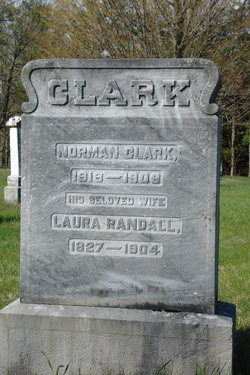
| Description | : | Plot 480 : - Norman Clark 1818-1909 - his wife, Laura Randall 1827-1904 ----------------------------------- Death Notice - The Lanark Era Newspaper - Issue of Wednesday, January 18,1905 - At Mississippi, Dec. 24th,1904, Mrs. Norman Clark. Burial in Crawford's Cemetery. |
frequently asked questions (FAQ):
-
Where is Laura Randall Clark's memorial?
Laura Randall Clark's memorial is located at: All Saints Churchyard, Selworthy, West Somerset District, England.
-
When did Laura Randall Clark death?
Laura Randall Clark death on 24 Dec 1904 in Mississippi Station, Frontenac County, Ontario, Canada
-
Where are the coordinates of the Laura Randall Clark's memorial?
Latitude: 51.2101800
Longitude: -3.5475440
Family Members:
Spouse

Children
Flowers:


Nearby Cemetories:
1. All Saints Churchyard
Selworthy, West Somerset District, England
Coordinate: 51.2101800, -3.5475440
2. Selworthy Extension Cemeteries
Selworthy, West Somerset District, England
Coordinate: 51.2098330, -3.5481240
3. St. Mary's Churchyard
Luccombe, West Somerset District, England
Coordinate: 51.1895770, -3.5596880
4. Luccombe Extension Cemetery
Luccombe, West Somerset District, England
Coordinate: 51.1897360, -3.5609100
5. St Dubricius Churchyard
Porlock, West Somerset District, England
Coordinate: 51.2083000, -3.5955000
6. Porlock Cemetery
Porlock, West Somerset District, England
Coordinate: 51.2033790, -3.5954070
7. Minehead Cemetery
Minehead, West Somerset District, England
Coordinate: 51.2050650, -3.4982030
8. All Saints Churchyard
Wootton Courtenay, West Somerset District, England
Coordinate: 51.1801840, -3.5203550
9. St. Michael's Anglican Church Cemetery
Minehead, West Somerset District, England
Coordinate: 51.2110390, -3.4808250
10. Stoke Pero Churchyard
Porlock, West Somerset District, England
Coordinate: 51.1796510, -3.6060674
11. St. Petrock's Churchyard
Timberscombe, West Somerset District, England
Coordinate: 51.1680950, -3.4948210
12. Grabbist Hill Cemetery
Dunster, West Somerset District, England
Coordinate: 51.1820510, -3.4492540
13. George Street Cemetery
Dunster, West Somerset District, England
Coordinate: 51.1833740, -3.4483046
14. St. John the Evangelist Churchyard
Cutcombe, West Somerset District, England
Coordinate: 51.1424576, -3.5295319
15. Priory Churchyard of St. George
Dunster, West Somerset District, England
Coordinate: 51.1832000, -3.4459000
16. Culbone St. Bueno's Churchyard
Oare, West Somerset District, England
Coordinate: 51.2213640, -3.6594820
17. Saint John the Baptist Churchyard
Carhampton, West Somerset District, England
Coordinate: 51.1746000, -3.4186000
18. Blesssed Virgin Mary Churchyard
Luxborough, West Somerset District, England
Coordinate: 51.1321490, -3.4680500
19. St. Mary Magdalene Churchyard
Exford, West Somerset District, England
Coordinate: 51.1341450, -3.6342160
20. St Nicholas Churchyard
Withycombe, West Somerset District, England
Coordinate: 51.1624530, -3.4096990
21. St. Mary the Virgin Churchyard
Oare, West Somerset District, England
Coordinate: 51.2124350, -3.7164290
22. Winsford Churchyard
Winsford, West Somerset District, England
Coordinate: 51.1038000, -3.5665000
23. St. Andrew's Parish of Old Cleeve Churchyard
Old Cleeve, West Somerset District, England
Coordinate: 51.1683560, -3.3733090
24. St Peter's Church Exton
Exton, West Somerset District, England
Coordinate: 51.0925840, -3.5352300