
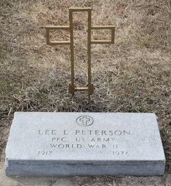
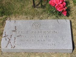
Lee L. Peterson
| Birth | : | 5 Apr 1917 Tulare, Spink County, South Dakota, USA |
| Death | : | 12 Jul 1976 Sioux Falls, Minnehaha County, South Dakota, USA |
| Burial | : | St Mary Extra Cemetery, Southampton, Southampton Unitary Authority, England |
| Coordinate | : | 50.8948700, -1.3522600 |
| Plot | : | Division G, Block 047, Grave 003 |
frequently asked questions (FAQ):
-
Where is Lee L. Peterson's memorial?
Lee L. Peterson's memorial is located at: St Mary Extra Cemetery, Southampton, Southampton Unitary Authority, England.
-
When did Lee L. Peterson death?
Lee L. Peterson death on 12 Jul 1976 in Sioux Falls, Minnehaha County, South Dakota, USA
-
Where are the coordinates of the Lee L. Peterson's memorial?
Latitude: 50.8948700
Longitude: -1.3522600
Family Members:
Parent
Spouse
Siblings
Flowers:


Nearby Cemetories:
1. St Mary Extra Cemetery
Southampton, Southampton Unitary Authority, England
Coordinate: 50.8948700, -1.3522600
2. St Mary Churchyard
Sholing, Southampton Unitary Authority, England
Coordinate: 50.8991260, -1.3571350
3. Holy Trinity Churchyard
Southampton, Southampton Unitary Authority, England
Coordinate: 50.8896750, -1.3659150
4. St. Mary Extra Churchyard
Southampton, Southampton Unitary Authority, England
Coordinate: 50.9040000, -1.3743000
5. Holy Saviour Churchyard
Bitterne, Southampton Unitary Authority, England
Coordinate: 50.9138840, -1.3583560
6. Redcote Convent Cemetery
Bitterne, Southampton Unitary Authority, England
Coordinate: 50.9168600, -1.3510700
7. St Mary the Virgin Churchyard
Hound, Eastleigh Borough, England
Coordinate: 50.8762820, -1.3322160
8. St Mary Churchyard
Southampton, Southampton Unitary Authority, England
Coordinate: 50.9027100, -1.3960800
9. Albert Road Cemetery
Hedge End, Eastleigh Borough, England
Coordinate: 50.9066535, -1.3099266
10. Netley Military Cemetery
Netley, Eastleigh Borough, England
Coordinate: 50.8682632, -1.3317170
11. St. Leonard Churchyard
Bursledon, Eastleigh Borough, England
Coordinate: 50.8850230, -1.3068370
12. St John the Evangelist Churchyard
Hedge End, Eastleigh Borough, England
Coordinate: 50.9089200, -1.3091100
13. St James Churchyard
West End, Eastleigh Borough, England
Coordinate: 50.9243200, -1.3382300
14. All Saints Catacombs and Burial Ground (Defunct)
Southampton, Southampton Unitary Authority, England
Coordinate: 50.9013350, -1.4021500
15. St. Julien's Church
Southampton, Southampton Unitary Authority, England
Coordinate: 50.8965000, -1.4036000
16. Holyrood Church
Southampton Unitary Authority, England
Coordinate: 50.8997498, -1.4034560
17. Holyrood Churchyard
Southampton, Southampton Unitary Authority, England
Coordinate: 50.8996600, -1.4035300
18. St Lawrence with St John Churchyard
Southampton, Southampton Unitary Authority, England
Coordinate: 50.8977570, -1.4052470
19. St Michael the Archangel Churchyard
Southampton, Southampton Unitary Authority, England
Coordinate: 50.8996200, -1.4056900
20. St. James' Church Cemetery
West End, Eastleigh Borough, England
Coordinate: 50.9267690, -1.3326580
21. St John the Baptist Churchyard
Hythe, New Forest District, England
Coordinate: 50.8688500, -1.3985000
22. West End Cemetery and Memorial Gardens
West End, Eastleigh Borough, England
Coordinate: 50.9342600, -1.3316300
23. St Andrew the Apostle Churchyard
Hamble-le-Rice, Eastleigh Borough, England
Coordinate: 50.8589100, -1.3179090
24. Highfield Churchyard
Portswood, Southampton Unitary Authority, England
Coordinate: 50.9295400, -1.3949800