

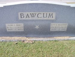
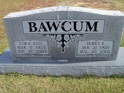
Lela Myrtle Malin Bawcum
| Birth | : | 25 Oct 1895 |
| Death | : | 2 Sep 1981 |
| Burial | : | Liberty Cemetery, Marion, McDowell County, USA |
| Coordinate | : | 35.6892014, -82.0939026 |
| Description | : | She married James Mirten Bawcum on 18 Jan 1914 in Benton Co, TN Eastern Star. DM with James Mirt Bawcum. |
frequently asked questions (FAQ):
-
Where is Lela Myrtle Malin Bawcum's memorial?
Lela Myrtle Malin Bawcum's memorial is located at: Liberty Cemetery, Marion, McDowell County, USA.
-
When did Lela Myrtle Malin Bawcum death?
Lela Myrtle Malin Bawcum death on 2 Sep 1981 in
-
Where are the coordinates of the Lela Myrtle Malin Bawcum's memorial?
Latitude: 35.6892014
Longitude: -82.0939026
Family Members:
Parent

Spouse
Siblings

Children
Flowers:


Nearby Cemetories:
1. Liberty Cemetery
Marion, McDowell County, USA
Coordinate: 35.6892014, -82.0939026
2. Vess Family Cemetery
Pleasant Gardens, McDowell County, USA
Coordinate: 35.6993532, -82.0866362
3. Patton Cemetery
McDowell County, USA
Coordinate: 35.7008630, -82.0873780
4. Mount Olive Cemetery
Pleasant Gardens, McDowell County, USA
Coordinate: 35.6815300, -82.1076500
5. Patton-Logan Cemetery
Pleasant Gardens, McDowell County, USA
Coordinate: 35.6907230, -82.0767370
6. Pleasant Gardens Baptist Church Cemetery
Marion, McDowell County, USA
Coordinate: 35.6933390, -82.0719010
7. Brown Family Cemetery
Pleasant Gardens, McDowell County, USA
Coordinate: 35.6967239, -82.0679550
8. Greenlee Hill Cemetery
McDowell County, USA
Coordinate: 35.6688700, -82.1106810
9. Carsons Chapel Cemetery
McDowell County, USA
Coordinate: 35.7070550, -82.0706850
10. McDowell Cemetery
McDowell County, USA
Coordinate: 35.6638380, -82.0587210
11. Round Hill Baptist Church Cemetery
McDowell County, USA
Coordinate: 35.7050620, -82.0468440
12. Nix Creek Free Will Baptist Church
Marion, McDowell County, USA
Coordinate: 35.6461500, -82.0699590
13. Mount Calvary Free Will Baptist Church Cemetery
McDowell County, USA
Coordinate: 35.6617550, -82.0401430
14. Glades Cemetery
McDowell County, USA
Coordinate: 35.6422005, -82.0669022
15. Ebenezer United Methodist Church Cemetery
Old Fort, McDowell County, USA
Coordinate: 35.6497002, -82.1453018
16. Elliott Cemetery
McDowell County, USA
Coordinate: 35.7382830, -82.1362160
17. Cross Mill Cemetery
Marion, McDowell County, USA
Coordinate: 35.6736341, -82.0221047
18. Old Ebenezer Cemetery
Old Fort, McDowell County, USA
Coordinate: 35.6432360, -82.1433220
19. Zion Hill Baptist Church Cemetery
Marion, McDowell County, USA
Coordinate: 35.6314011, -82.0686035
20. Simmons Cemetery
Sunnyvale, McDowell County, USA
Coordinate: 35.7394070, -82.1381670
21. Craig Family Cemetery
McDowell County, USA
Coordinate: 35.7403200, -82.0500100
22. Proctor-Henline Cemetery
Marion, McDowell County, USA
Coordinate: 35.7047030, -82.0192750
23. Providence United Methodist Church Cemetery
Marion, McDowell County, USA
Coordinate: 35.6368860, -82.0503680
24. West Marion United Methodist Church Cemetery
Marion, McDowell County, USA
Coordinate: 35.6609920, -82.0235890