
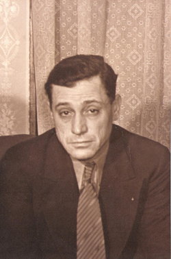
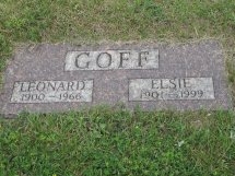
Leonard Benjamin Goff
| Birth | : | 18 Sep 1900 Lidgerwood, Richland County, North Dakota, USA |
| Death | : | 1 Dec 1966 Wahpeton, Richland County, North Dakota, USA |
| Burial | : | Tuttle Cemetery, Tuttle, Kidder County, USA |
| Coordinate | : | 47.1397018, -100.0077972 |
| Plot | : | Block 11b |
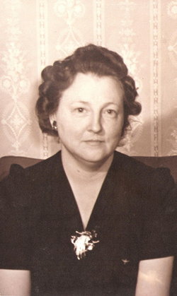
| Description | : | Son of Frank Louis Goff and Adelaide Charlotte Allen. Married 03 Sep 1921 to Elsie Elaine Worcester. |
frequently asked questions (FAQ):
-
Where is Leonard Benjamin Goff's memorial?
Leonard Benjamin Goff's memorial is located at: Tuttle Cemetery, Tuttle, Kidder County, USA.
-
When did Leonard Benjamin Goff death?
Leonard Benjamin Goff death on 1 Dec 1966 in Wahpeton, Richland County, North Dakota, USA
-
Where are the coordinates of the Leonard Benjamin Goff's memorial?
Latitude: 47.1397018
Longitude: -100.0077972
Family Members:
Parent
Spouse
Siblings

Children
Flowers:


Nearby Cemetories:
1. Tuttle Cemetery
Tuttle, Kidder County, USA
Coordinate: 47.1397018, -100.0077972
2. Holy Cross Cemetery
Tuttle, Kidder County, USA
Coordinate: 47.1408005, -99.9464035
3. Zion Langedahl Cemetery
Kidder County, USA
Coordinate: 47.0825005, -100.0714035
4. Evangelical Immanuel Cemetery
Tuttle, Kidder County, USA
Coordinate: 47.0963000, -100.0950000
5. Chestina Cemetery
Kidder County, USA
Coordinate: 47.0539330, -100.0408600
6. Skudesness Lutheran Cemetery
Kidder County, USA
Coordinate: 47.0466995, -100.0072021
7. Saint Johns Cemetery
Arena, Burleigh County, USA
Coordinate: 47.1343994, -100.1564026
8. Saint Petri Cemetery
Kidder County, USA
Coordinate: 47.2291985, -99.9064026
9. Kleve Cemetery
Robinson, Kidder County, USA
Coordinate: 47.1112800, -99.8404200
10. Mennonite Zion Cemetery
Arena, Burleigh County, USA
Coordinate: 47.0794400, -100.1572400
11. Phoenix Township Cemetery
Arena, Burleigh County, USA
Coordinate: 47.1854000, -100.1996000
12. Zion Lutheran Church Cemetery
Driscoll, Burleigh County, USA
Coordinate: 46.9961900, -100.1700600
13. Bethany Cemetery
Robinson, Kidder County, USA
Coordinate: 47.1392300, -99.7351000
14. Wing Cemetery
Wing, Burleigh County, USA
Coordinate: 47.1380000, -100.2830000
15. Richmond Cemetery
Wing, Burleigh County, USA
Coordinate: 47.1922020, -100.2832570
16. Hazel Grove Cemetery
Wing, Burleigh County, USA
Coordinate: 47.3150940, -100.1690700
17. Stark Mennonite Church Cemetery
Wing, Burleigh County, USA
Coordinate: 47.3153800, -100.1770700
18. Seventh Day Adventist Cemetery
Robinson, Kidder County, USA
Coordinate: 47.2129500, -99.7148400
19. Ahola Cemetery
Wing, Burleigh County, USA
Coordinate: 47.0250626, -100.2952423
20. Allen Cemetery
Kidder County, USA
Coordinate: 46.9155998, -99.8647003
21. Fairview Cemetery
Lake Williams, Kidder County, USA
Coordinate: 47.0816803, -99.6518784
22. Chaska Gravesite
Driscoll, Burleigh County, USA
Coordinate: 46.9015700, -100.1330700
23. Methodist Episcopal Cemetery
Robinson, Kidder County, USA
Coordinate: 47.2972590, -99.7149830
24. Woodlawn Cemetery
Steele, Kidder County, USA
Coordinate: 46.8806000, -99.9094009