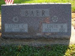
Lester Cornell Baer
| Birth | : | 19 Jan 1900 Monticello, White County, Indiana, USA |
| Death | : | 27 Mar 1987 Monticello, White County, Indiana, USA |
| Burial | : | St. Botolph’s Churchyard, Shepshed, Charnwood Borough, England |
| Coordinate | : | 52.7726830, -1.2885670 |
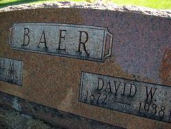
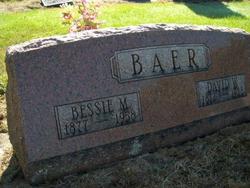
| Description | : | MONTICELLO - Lester C. Baer, 87, Idaville, died at 3:15 a.m. today in Monticello Health Care Center, Monticello. He was born Jan. 19, 1900, in Monticello to David W. and Bessie M. Cornell Baer. He was married Aug. 29, 1925, to Edith Wheaton, who died March 24, 1980. He was a retired employee of Penn-Central Railroad, a farmer, and former owner and operator of Baer's Restaurant, Idaville. He was a member of Idaville Church of God and the Masonic Lodge, Burnettsville. Surviving are three sons, Eugene W., Sun City, Ariz., Lester D. (Jack), Rensselaer, and Richard, Crown... Read More |
frequently asked questions (FAQ):
-
Where is Lester Cornell Baer's memorial?
Lester Cornell Baer's memorial is located at: St. Botolph’s Churchyard, Shepshed, Charnwood Borough, England.
-
When did Lester Cornell Baer death?
Lester Cornell Baer death on 27 Mar 1987 in Monticello, White County, Indiana, USA
-
Where are the coordinates of the Lester Cornell Baer's memorial?
Latitude: 52.7726830
Longitude: -1.2885670
Family Members:
Parent
Spouse
Siblings
Children
Flowers:
Nearby Cemetories:
1. St. Botolph’s Churchyard
Shepshed, Charnwood Borough, England
Coordinate: 52.7726830, -1.2885670
2. Shepshed Cemetery
Shepshed, Charnwood Borough, England
Coordinate: 52.7640470, -1.2963120
3. St. James the Greater Oaks in Charnwood
Whitwick, North West Leicestershire District, England
Coordinate: 52.7425430, -1.3008590
4. St John Churchyard
Belton, North West Leicestershire District, England
Coordinate: 52.7830810, -1.3374590
5. St. Peters & St. Paul Cemetery
Hathern, Charnwood Borough, England
Coordinate: 52.7970560, -1.2558040
6. All Saints' Church Dishley
Hathern, Charnwood Borough, England
Coordinate: 52.7860705, -1.2412000
7. All Saints Churchyard
Thorpe Acre, Charnwood Borough, England
Coordinate: 52.7750466, -1.2361551
8. Greenhill Rise Cemetery
Hathern, Charnwood Borough, England
Coordinate: 52.7990180, -1.2576160
9. All Saints Churchyard
Long Whatton, North West Leicestershire District, England
Coordinate: 52.8052840, -1.2859690
10. Mount St Bernard Abbey
Whitwick, North West Leicestershire District, England
Coordinate: 52.7413880, -1.3234470
11. Grace-Dieu Priory
Thringstone, North West Leicestershire District, England
Coordinate: 52.7609720, -1.3566830
12. St Mary the Blessed Virgin Church
Osgathorpe, North West Leicestershire District, England
Coordinate: 52.7715890, -1.3623270
13. Emmanuel Churchyard
Loughborough, Charnwood Borough, England
Coordinate: 52.7668830, -1.2108020
14. St Michael & All Angels Churchyard
Long Whatton, North West Leicestershire District, England
Coordinate: 52.8164170, -1.3282730
15. All Saints with Holy Trinity Churchyard
Loughborough, Charnwood Borough, England
Coordinate: 52.7743880, -1.2035500
16. St John the Baptist Churchyard
Whitwick, North West Leicestershire District, England
Coordinate: 52.7416040, -1.3571200
17. St. Andrew's Churchyard
Thringstone, North West Leicestershire District, England
Coordinate: 52.7529090, -1.3692140
18. St. Anne's Churchyard
Sutton Bonington, Rushcliffe Borough, England
Coordinate: 52.8206200, -1.2485400
19. Whitwick Cemetery
Whitwick, North West Leicestershire District, England
Coordinate: 52.7395560, -1.3623360
20. St. Michael's Churchyard
Sutton Bonington, Rushcliffe Borough, England
Coordinate: 52.8240654, -1.2529907
21. Marle Pit Hill Cemetery
Sutton Bonington, Rushcliffe Borough, England
Coordinate: 52.8241820, -1.2525970
22. Broomleys Cemetery
Coalville, North West Leicestershire District, England
Coordinate: 52.7255540, -1.3402280
23. Loughborough Crematorium
Loughborough, Charnwood Borough, England
Coordinate: 52.7575650, -1.1965200
24. Loughborough Cemetery
Loughborough, Charnwood Borough, England
Coordinate: 52.7599400, -1.1951700

