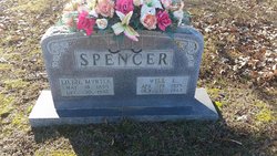
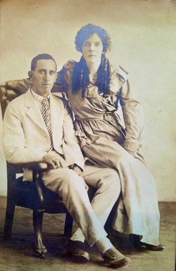
Lillie Myrtle Smith Spencer
| Birth | : | 18 May 1895 Logan County, Arkansas, USA |
| Death | : | 30 Dec 1982 Friendship, Crockett County, Tennessee, USA |
| Burial | : | Mount Moriah Cemetery, Friendship, Crockett County, USA |
| Coordinate | : | 35.8955420, -89.2576300 |
| Description | : | Lillie was married to James Wesley Pritchard and they had two children: Erma Lou Pritchard and John "Jake" Wesley Pritchard. James Pritchard died on 9 Jan 1919. Lillie married William Edgar Spencer Sr. on 15 Dec 1922 in Crockett County, TN. She was well liked and respected by Mr. Spencer's grandchildren and to this day they still have kind things to say about her. Lillie is the daughter of Joseph Anthony Smith 1872- 1901 buried in Logan County Arkansas. Louisa Grist Smith is her mother. Unknown where she may be buried. It is suspected that her Mother is "Loue Brassfield" buried... Read More |
frequently asked questions (FAQ):
-
Where is Lillie Myrtle Smith Spencer's memorial?
Lillie Myrtle Smith Spencer's memorial is located at: Mount Moriah Cemetery, Friendship, Crockett County, USA.
-
When did Lillie Myrtle Smith Spencer death?
Lillie Myrtle Smith Spencer death on 30 Dec 1982 in Friendship, Crockett County, Tennessee, USA
-
Where are the coordinates of the Lillie Myrtle Smith Spencer's memorial?
Latitude: 35.8955420
Longitude: -89.2576300
Family Members:
Spouse
Children
Flowers:
Nearby Cemetories:
1. Mount Moriah Cemetery
Friendship, Crockett County, USA
Coordinate: 35.8955420, -89.2576300
2. Robertson-Warren Cemetery
Friendship, Crockett County, USA
Coordinate: 35.8830700, -89.2427200
3. Bellevernon Cemetery
Friendship, Crockett County, USA
Coordinate: 35.9135830, -89.2495910
4. Friendship Cemetery
Friendship, Crockett County, USA
Coordinate: 35.9146430, -89.2381450
5. Zion Hill Church Cemetery
Friendship, Dyer County, USA
Coordinate: 35.9095110, -89.2900760
6. Browder Family Cemetery
Broadview, Crockett County, USA
Coordinate: 35.8646890, -89.2623010
7. Hardin Cemetery
Friendship, Dyer County, USA
Coordinate: 35.9243270, -89.2766430
8. Mose M. Thompson Cemetery
Friendship, Dyer County, USA
Coordinate: 35.9243680, -89.2765870
9. Mount Pisgah Cemetery
Friendship, Dyer County, USA
Coordinate: 35.9162470, -89.2901740
10. Nash Cemetery
Dyersburg, Dyer County, USA
Coordinate: 35.9252500, -89.2822230
11. Antioch Cemetery
Friendship, Crockett County, USA
Coordinate: 35.8581090, -89.2577800
12. Bowen Chapel Cemetery
Friendship, Dyer County, USA
Coordinate: 35.9311810, -89.2353720
13. Old Dyer Church Cemetery
Friendship, Crockett County, USA
Coordinate: 35.8844600, -89.2101900
14. Cock and Irvin Cemetery
Hawkinsville, Dyer County, USA
Coordinate: 35.9104430, -89.3046210
15. Mount Zion Cemetery
Friendship, Crockett County, USA
Coordinate: 35.9131950, -89.2032590
16. Edwards Cemetery
Friendship, Crockett County, USA
Coordinate: 35.9314120, -89.2146810
17. Perry Cemetery
Maury Junction, Crockett County, USA
Coordinate: 35.8675600, -89.2051410
18. Staggs Cemetery
Friendship, Dyer County, USA
Coordinate: 35.9397930, -89.2896620
19. Scarborough Cemetery
Broadview, Crockett County, USA
Coordinate: 35.8432570, -89.2546330
20. Deaton Cemetery
Friendship, Crockett County, USA
Coordinate: 35.9350080, -89.2122640
21. Stallcup Family Cemetery
Cross Roads, Dyer County, USA
Coordinate: 35.8980720, -89.3245320
22. Floyds Chapel Cemetery
Broadview, Crockett County, USA
Coordinate: 35.8403860, -89.2592840
23. Hudson Grove Church Cemetery
Crockett Mills, Crockett County, USA
Coordinate: 35.8713410, -89.1956910
24. Siloam Cemetery
Dog Hill, Crockett County, USA
Coordinate: 35.8398940, -89.2832260


