
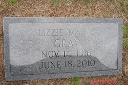
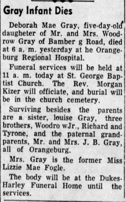
Lizzie Mae Fogle Gray
| Birth | : | 14 Nov 1916 Orangeburg County, South Carolina, USA |
| Death | : | 18 Jun 2010 Orangeburg, Orangeburg County, South Carolina, USA |
| Burial | : | St Andrew Churchyard, Gargrave, Craven District, England |
| Coordinate | : | 53.9811830, -2.1054420 |
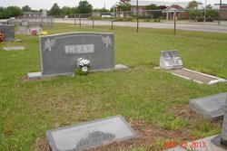
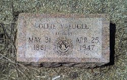
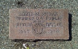
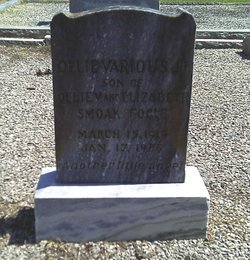
| Description | : | Orangeburg - Lizzie Mae Fogle Gray, 93, of Orangeburg, passed away Friday morning at Jolley Acres Healthcare Center. Funeral services will be held at 4:00 p.m. Sunday, June 20, 2010, at St. George Baptist Church, with Rev. Wayne Reeves officiating. Burial will follow at St. George Baptist Church Cemetery. Family will receive friends Saturday evening from 6 to 8 p.m. at Dukes-Harley Funeral Home. At other times, friends may call at the residence of Mr. and Mrs. Woodrow (Buck) Gray, Jr. Mrs. Gray was born in Orangeburg County a daughter of the late Ollie V. Fogle and Elizabeth Smoak Fogle.... Read More |
frequently asked questions (FAQ):
-
Where is Lizzie Mae Fogle Gray's memorial?
Lizzie Mae Fogle Gray's memorial is located at: St Andrew Churchyard, Gargrave, Craven District, England.
-
When did Lizzie Mae Fogle Gray death?
Lizzie Mae Fogle Gray death on 18 Jun 2010 in Orangeburg, Orangeburg County, South Carolina, USA
-
Where are the coordinates of the Lizzie Mae Fogle Gray's memorial?
Latitude: 53.9811830
Longitude: -2.1054420
Family Members:
Parent
Spouse

Siblings

Children

Flowers:


Nearby Cemetories:
1. St Andrew Churchyard
Gargrave, Craven District, England
Coordinate: 53.9811830, -2.1054420
2. St. Peter's Churchyard
Coniston Cold, Craven District, England
Coordinate: 53.9944380, -2.1493870
3. All Saints Churchyard
Broughton, Craven District, England
Coordinate: 53.9492880, -2.1019580
4. St. Peter's Churchyard
Martons Both, Craven District, England
Coordinate: 53.9522064, -2.1413111
5. St Peter Church
Martons Both, Craven District, England
Coordinate: 53.9522630, -2.1415720
6. Tarn Moor Memorial Woodland Burial Ground
Skipton, Craven District, England
Coordinate: 53.9759590, -2.0254260
7. St Mary the Virgin Churchyard
Carleton, Craven District, England
Coordinate: 53.9442300, -2.0417800
8. St Stephen Roman Catholic Churchyard
Skipton, Craven District, England
Coordinate: 53.9631760, -2.0210240
9. Raikes Road Burial Ground
Skipton, Craven District, England
Coordinate: 53.9643822, -2.0196819
10. Waltonwrays Cemetery and Skipton Crematorium
Skipton, Craven District, England
Coordinate: 53.9505500, -2.0272300
11. Holy Trinity Churchyard
Skipton, Craven District, England
Coordinate: 53.9633250, -2.0161180
12. Skipton War Memorial
Skipton, Craven District, England
Coordinate: 53.9627100, -2.0161680
13. Christ Churchyard
Skipton, Craven District, England
Coordinate: 53.9581200, -2.0188910
14. St Peter Churchyard
Rylstone, Craven District, England
Coordinate: 54.0253360, -2.0445780
15. St Mary the Virgin Churchyard
Thornton-in-Craven, Craven District, England
Coordinate: 53.9311350, -2.1513350
16. Friends Burial Ground at Skipton
Skipton, Craven District, England
Coordinate: 53.9599220, -2.0148630
17. St. Andrew's Churchyard
Skipton, Craven District, England
Coordinate: 53.9609959, -2.0140994
18. Saint Mary-le-Ghyll
Barnoldswick, Pendle Borough, England
Coordinate: 53.9279505, -2.1647004
19. Ghyll Cemetery
Barnoldswick, Pendle Borough, England
Coordinate: 53.9271100, -2.1646700
20. Earby Cemetery
Earby, Pendle Borough, England
Coordinate: 53.9189987, -2.1370001
21. St. Aidan's Churchyard
Hellifield, Craven District, England
Coordinate: 54.0042070, -2.2201370
22. St Mary Churchyard
Embsay, Craven District, England
Coordinate: 53.9829390, -1.9834030
23. St Michael the Archangel Churchyard
Kirkby Malham, Craven District, England
Coordinate: 54.0448480, -2.1628540
24. Bethel Chapel Cemetery
Lothersdale, Craven District, England
Coordinate: 53.9102184, -2.0749640