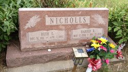
| Birth | : | 10 Aug 1910 Nelson, Nuckolls County, Nebraska, USA |
| Death | : | 25 Jul 2005 Geneva, Fillmore County, Nebraska, USA |
| Burial | : | Bolton Street Cemetery, Wellington, Wellington City, New Zealand |
| Coordinate | : | -41.2786810, 174.7727660 |
| Plot | : | Block 25, Lot 18, Grave 2 |
| Inscription | : | Parents of Norman, William, Max & Dina |
| Description | : | Lois Ida Mumford, the daughter of Dio Mark and Mabel W. (Campbell) Holsteen, was born August 10, 1910 at Nelson, Nebraska. She passed away on July 25, 2005 at Heritage Crossings Nursing Home at Geneva, Nebraska at the age of 94 years, 11 months and 15 days. Lois was a longtime Hebron and Nelson, Nebraska resident. She graduated from Nelson Public High School and the University of Nebraska at Lincoln. On May 31, 1937, she married Chrisley S. Mumford at Julesburg, Colorado. To this union were born three sons and one daughter: Norman Dean, William E., Max Gilbert, and... Read More |
frequently asked questions (FAQ):
-
Where is Lois Ida Holsteen Mumford's memorial?
Lois Ida Holsteen Mumford's memorial is located at: Bolton Street Cemetery, Wellington, Wellington City, New Zealand.
-
When did Lois Ida Holsteen Mumford death?
Lois Ida Holsteen Mumford death on 25 Jul 2005 in Geneva, Fillmore County, Nebraska, USA
-
Where are the coordinates of the Lois Ida Holsteen Mumford's memorial?
Latitude: -41.2786810
Longitude: 174.7727660
Family Members:
Parent
Spouse
Siblings
Flowers:
Nearby Cemetories:
1. Bolton Street Cemetery
Wellington, Wellington City, New Zealand
Coordinate: -41.2786810, 174.7727660
2. Mount Street Cemetery
Wellington, Wellington City, New Zealand
Coordinate: -41.2888040, 174.7713370
3. Karori Cemetery and Crematorium
Wellington, Wellington City, New Zealand
Coordinate: -41.2804030, 174.7512000
4. New Zealand National War Memorial
Wellington, Wellington City, New Zealand
Coordinate: -41.2990000, 174.7771620
5. Saint Mary's Anglican Churchyard
Wellington, Wellington City, New Zealand
Coordinate: -41.2826680, 174.7438880
6. Massey Memorial
Wellington, Wellington City, New Zealand
Coordinate: -41.2850700, 174.8259900
7. Truby King House and Gardens
Melrose, Wellington City, New Zealand
Coordinate: -41.3201760, 174.7889800
8. Our Lady’s Home of Compassion
Island Bay, Wellington City, New Zealand
Coordinate: -41.3287970, 174.7704430
9. St. Matthias Anglican Church Cemetery
Makara, Wellington City, New Zealand
Coordinate: -41.2694440, 174.7047270
10. Tapu Te Ranga Marae
Wellington City, New Zealand
Coordinate: -41.3316963, 174.7698099
11. Makara Cemetery
Wellington, Wellington City, New Zealand
Coordinate: -41.2769430, 174.7016600
12. Johnsonville Methodist Cemetery
Wellington, Wellington City, New Zealand
Coordinate: -41.2229000, 174.8083500
13. St. John's Anglican Churchyard Cemetery
Johnsonville, Wellington City, New Zealand
Coordinate: -41.2201300, 174.8076800
14. Somes Island
Wellington, Wellington City, New Zealand
Coordinate: -41.2548630, 174.8650830
15. Holy Trinity Cemetery
Ohariu, Wellington City, New Zealand
Coordinate: -41.2000860, 174.7793400
16. Te Puni Urupā
Petone, Lower Hutt City, New Zealand
Coordinate: -41.2254898, 174.8686975
17. Korokoro Catholic Cemetery
Lower Hutt, Lower Hutt City, New Zealand
Coordinate: -41.2210110, 174.8702590
18. Pencarrow Head
Eastbourne, Lower Hutt City, New Zealand
Coordinate: -41.3574100, 174.8505900
19. Owhiti Urupā
Seaview, Lower Hutt City, New Zealand
Coordinate: -41.2358800, 174.9044500
20. Bridge Street Cemetery
Lower Hutt, Lower Hutt City, New Zealand
Coordinate: -41.2117740, 174.8969660
21. St. James Churchyard
Lower Hutt, Lower Hutt City, New Zealand
Coordinate: -41.2128840, 174.9003910
22. Grasslees Reserve
Tawa, Wellington City, New Zealand
Coordinate: -41.1647415, 174.8284302
23. Tawa Flat Cemetery
Tawa, Wellington City, New Zealand
Coordinate: -41.1580600, 174.8281800
24. Homedale Methodist Cemetery
Wainuiomata, Lower Hutt City, New Zealand
Coordinate: -41.2780500, 174.9527000


