
| Birth | : | 25 Nov 1928 Leon, Decatur County, Iowa, USA |
| Death | : | 14 Mar 2019 Council Bluffs, Pottawattamie County, Iowa, USA |
| Burial | : | Lewis Township Cemetery, Council Bluffs, Pottawattamie County, USA |
| Coordinate | : | 41.2117004, -95.7938995 |
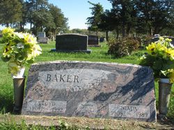
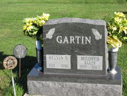
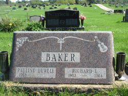
| Description | : | Benscoter-Agnew, Lois Louise Lois Louise Benscoter-Agnew, age 90, of Council Bluffs, passed away on March 14, 2019. She was born November 25, 1928, in Leon, Iowa, to the late Lloyd and Niada (Merrill) Baker. In addition to her parents, she was preceded in death by her husband, Leo Benscoter; second husband, Harold Agnew; son, Steven Benscoter; brother, Richard Baker; sister, Mildred Gartner; brother, Lyle Baker. Lois is survived by her daughter, Louisa Taylor (Mike); grandchildren, Rachel Kapp (Jacob) and Matthew Taylor; great-grandchildren, Coby Kapp and Rebecca Kapp; siblings, Lowell Baker (Donna), Kay Stott (JL); sisters-in-law, Pauline Baker and... Read More |
frequently asked questions (FAQ):
-
Where is Lois Louise Baker Benscoter - Agnew's memorial?
Lois Louise Baker Benscoter - Agnew's memorial is located at: Lewis Township Cemetery, Council Bluffs, Pottawattamie County, USA.
-
When did Lois Louise Baker Benscoter - Agnew death?
Lois Louise Baker Benscoter - Agnew death on 14 Mar 2019 in Council Bluffs, Pottawattamie County, Iowa, USA
-
Where are the coordinates of the Lois Louise Baker Benscoter - Agnew's memorial?
Latitude: 41.2117004
Longitude: -95.7938995
Family Members:
Parent

Spouse

Siblings
Children
Flowers:


Nearby Cemetories:
1. Lewis Township Cemetery
Council Bluffs, Pottawattamie County, USA
Coordinate: 41.2117004, -95.7938995
2. Maple Grove Cemetery
Council Bluffs, Pottawattamie County, USA
Coordinate: 41.2265560, -95.8187100
3. Stoker-Graybill Cemetery
Council Bluffs, Pottawattamie County, USA
Coordinate: 41.2532620, -95.7751770
4. Clark Cemetery
Pottawattamie County, USA
Coordinate: 41.2551610, -95.8223390
5. Saint Pauls Evangelical Country Church Cemetery
Dumfries, Pottawattamie County, USA
Coordinate: 41.1748352, -95.7492371
6. Memorial Park Cemetery
Council Bluffs, Pottawattamie County, USA
Coordinate: 41.2644005, -95.8261032
7. Cedar Lawn Cemetery
Council Bluffs, Pottawattamie County, USA
Coordinate: 41.2694016, -95.8182983
8. Zion Cemetery
Pottawattamie County, USA
Coordinate: 41.1778000, -95.7272000
9. Salem Lutheran Church Cemetery
Glenwood, Mills County, USA
Coordinate: 41.1556015, -95.7617035
10. Oak Hill Cemetery
Council Bluffs, Pottawattamie County, USA
Coordinate: 41.2700900, -95.8226400
11. Bikhor Cholim Cemetery
Council Bluffs, Pottawattamie County, USA
Coordinate: 41.2703670, -95.8229350
12. Ridgewood Cemetery
Council Bluffs, Pottawattamie County, USA
Coordinate: 41.2694016, -95.8272018
13. Saint Joseph Cemetery
Council Bluffs, Pottawattamie County, USA
Coordinate: 41.2722015, -95.8208008
14. Council Point Cemetery
Council Bluffs, Pottawattamie County, USA
Coordinate: 41.2110830, -95.8788610
15. Walnut Hill Cemetery
Council Bluffs, Pottawattamie County, USA
Coordinate: 41.2719002, -95.8255997
16. Green Valley Cemetery
Council Bluffs, Pottawattamie County, USA
Coordinate: 41.2743988, -95.8225021
17. Fairview Cemetery
Council Bluffs, Pottawattamie County, USA
Coordinate: 41.2703018, -95.8480988
18. Saint Marys Cemetery
Mills County, USA
Coordinate: 41.1517580, -95.8514000
19. Saint Boniface Catholic Cemetery
Mills County, USA
Coordinate: 41.1419000, -95.7467100
20. Keg Creek Township Cemetery
Treynor, Pottawattamie County, USA
Coordinate: 41.1913986, -95.6893997
21. Garner Cemetery
Council Bluffs, Pottawattamie County, USA
Coordinate: 41.2956161, -95.8001709
22. Fontenelle Forest Cemetery
Bellevue, Sarpy County, USA
Coordinate: 41.1636430, -95.8887200
23. Saar's Field Cemetery
Mills County, USA
Coordinate: 41.1255500, -95.7725000
24. Wall Cemetery
Mineola, Mills County, USA
Coordinate: 41.1157990, -95.8153000