
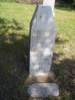
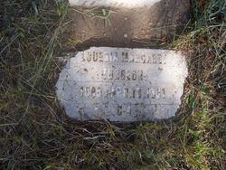
Louesia Margaret Turgeon
| Birth | : | 18 May 1889 Charles Mix County, South Dakota, USA |
| Death | : | 18 Apr 1891 Charles Mix County, South Dakota, USA |
| Burial | : | Blackfield Cemetery, Blackfield, New Forest District, England |
| Coordinate | : | 50.8146700, -1.3756600 |
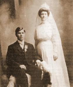
| Description | : | Daughter of Abraham Turgeon and Margaret Langdeau. |
frequently asked questions (FAQ):
-
Where is Louesia Margaret Turgeon's memorial?
Louesia Margaret Turgeon's memorial is located at: Blackfield Cemetery, Blackfield, New Forest District, England.
-
When did Louesia Margaret Turgeon death?
Louesia Margaret Turgeon death on 18 Apr 1891 in Charles Mix County, South Dakota, USA
-
Where are the coordinates of the Louesia Margaret Turgeon's memorial?
Latitude: 50.8146700
Longitude: -1.3756600
Family Members:
Parent
Siblings

Flowers:


Nearby Cemetories:
1. Blackfield Cemetery
Blackfield, New Forest District, England
Coordinate: 50.8146700, -1.3756600
2. Waterside Methodist Chapelyard
Fawley, New Forest District, England
Coordinate: 50.8245300, -1.3597900
3. St Katherine Churchyard
Exbury and Lepe, New Forest District, England
Coordinate: 50.8003950, -1.3957510
4. All Saints Churchyard
Fawley, New Forest District, England
Coordinate: 50.8297700, -1.3522200
5. Blessed Virgin and Holy Child Churchyard
Beaulieu, New Forest District, England
Coordinate: 50.8216320, -1.4501550
6. Beaulieu Cemetery
Beaulieu, New Forest District, England
Coordinate: 50.8046600, -1.4594000
7. St John the Baptist Churchyard
Hythe, New Forest District, England
Coordinate: 50.8688500, -1.3985000
8. St Andrew the Apostle Churchyard
Hamble-le-Rice, Eastleigh Borough, England
Coordinate: 50.8589100, -1.3179090
9. Netley Military Cemetery
Netley, Eastleigh Borough, England
Coordinate: 50.8682632, -1.3317170
10. St Paul Churchyard
East Boldre, New Forest District, England
Coordinate: 50.8011710, -1.4693300
11. East Boldre Baptist Chapelyard
East Boldre, New Forest District, England
Coordinate: 50.8044770, -1.4707650
12. St Mary Churchyard
Warsash, Fareham Borough, England
Coordinate: 50.8473220, -1.2910610
13. East Boldre Old Chapelyard
East Boldre, New Forest District, England
Coordinate: 50.8100600, -1.4756000
14. Holy Trinity Churchyard
Cowes, Isle of Wight Unitary Authority, England
Coordinate: 50.7661800, -1.3024540
15. St Mary the Virgin Churchyard
Hound, Eastleigh Borough, England
Coordinate: 50.8762820, -1.3322160
16. St Mary's Churchyard
Cowes, Isle of Wight Unitary Authority, England
Coordinate: 50.7629580, -1.3015790
17. All Saints Churchyard
Dibden, New Forest District, England
Coordinate: 50.8753020, -1.4362590
18. Holy Trinity Churchyard
Southampton, Southampton Unitary Authority, England
Coordinate: 50.8896750, -1.3659150
19. Holly Hill Cemetery
Sarisbury, Fareham Borough, England
Coordinate: 50.8678930, -1.2888890
20. Northwood Cemetery
Cowes, Isle of Wight Unitary Authority, England
Coordinate: 50.7513700, -1.3003600
21. St James Churchyard
East Cowes, Isle of Wight Unitary Authority, England
Coordinate: 50.7579430, -1.2861300
22. St Mary Extra Cemetery
Southampton, Southampton Unitary Authority, England
Coordinate: 50.8948700, -1.3522600
23. St. Leonard Churchyard
Bursledon, Eastleigh Borough, England
Coordinate: 50.8850230, -1.3068370
24. St Paul Churchyard
Sarisbury, Fareham Borough, England
Coordinate: 50.8756100, -1.2870670