
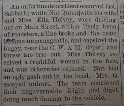
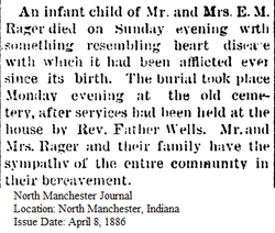
| Birth | : | 22 Jan 1855 Wayne County, Ohio, USA |
| Death | : | 17 Oct 1889 North Manchester, Wabash County, Indiana, USA |
| Burial | : | Pukekohe Public Cemetery, Pukekohe, Auckland Council, New Zealand |
| Coordinate | : | -37.2106400, 174.8974900 |
| Description | : | Daughter of Elias M. Rager and Mary Reichard. Her mother, Mary, died when Fannie was about two months old (her obituary reads "two weeks old," but the dates appear to be two months). Fannie married Thomas D. Spencer. Following Fannie's death, her sister, Harriet, moved in with the family in order to take care of the children. Harried died of typhoid fever in 1899. Most all of the Spencer family was deathly ill of the same disease at the time. Escerpt from obituary: Louisa F Rager , daughter of Elias M and Mary J... Read More |
frequently asked questions (FAQ):
-
Where is Louise Fannie Rager Spencer's memorial?
Louise Fannie Rager Spencer's memorial is located at: Pukekohe Public Cemetery, Pukekohe, Auckland Council, New Zealand.
-
When did Louise Fannie Rager Spencer death?
Louise Fannie Rager Spencer death on 17 Oct 1889 in North Manchester, Wabash County, Indiana, USA
-
Where are the coordinates of the Louise Fannie Rager Spencer's memorial?
Latitude: -37.2106400
Longitude: 174.8974900
Family Members:
Parent

Spouse
Siblings
Children
Flowers:


Nearby Cemetories:
1. Pukekohe Public Cemetery
Pukekohe, Auckland Council, New Zealand
Coordinate: -37.2106400, 174.8974900
2. Pukekohe Catholic Cemetery
Pukekohe, Auckland Council, New Zealand
Coordinate: -37.1951510, 174.9014640
3. Heights Park Cemetery
Paerata, Auckland Council, New Zealand
Coordinate: -37.1781928, 174.8938836
4. Pukekohe East Cemetery
Pukekohe East, Auckland Council, New Zealand
Coordinate: -37.1883500, 174.9459000
5. St Brides Church of England Cemetery
Mauku, Auckland Council, New Zealand
Coordinate: -37.2011260, 174.8120370
6. Mauku Cemetery
Mauku, Auckland Council, New Zealand
Coordinate: -37.2011420, 174.8109100
7. Bombay Presbyterian Church Cemetery
Bombay, Auckland Council, New Zealand
Coordinate: -37.1790700, 174.9826900
8. St. Peter's in the Forest Anglican Cemetery
Bombay, Auckland Council, New Zealand
Coordinate: -37.1869100, 174.9914100
9. Alexandra Redoubt Cemetery
Tuakau, Waikato District, New Zealand
Coordinate: -37.2858200, 174.9419600
10. Tuakau Cemetery
Tuakau, Waikato District, New Zealand
Coordinate: -37.2844420, 174.9465660
11. Mauku Historical Cemetery
Mauku, Auckland Council, New Zealand
Coordinate: -37.1743690, 174.7951870
12. Pokeno Old Soldiers Cemetery
Pokeno, Waikato District, New Zealand
Coordinate: -37.2386120, 175.0094760
13. Pratt's Road Catholic Cemetery
Ramarama, Auckland Council, New Zealand
Coordinate: -37.1425500, 174.9871300
14. Pokeno Cemetery
Pokeno, Waikato District, New Zealand
Coordinate: -37.2364600, 175.0215400
15. Onewhero Cemetery
Onewhero, Waikato District, New Zealand
Coordinate: -37.3158900, 174.9104900
16. St John's Anglican Cemetery Drury
Drury, Auckland Council, New Zealand
Coordinate: -37.1033710, 174.9506070
17. Drury-Runciman War Memorial
Drury, Auckland Council, New Zealand
Coordinate: -37.1025480, 174.9528240
18. Drury Presbyterian Cemetery
Drury, Auckland Council, New Zealand
Coordinate: -37.0991270, 174.9497870
19. Ararimu Schoolhouse Cemetery
Ararimu, Auckland Council, New Zealand
Coordinate: -37.1448376, 175.0359288
20. Papakura South Cemetery
Papakura, Auckland Council, New Zealand
Coordinate: -37.0877300, 174.9464700
21. Waiau Pa Cemetery
Waiau Pa, Auckland Council, New Zealand
Coordinate: -37.1327190, 174.7573970
22. Manutahi Urupā
Port Waikato, Waikato District, New Zealand
Coordinate: -37.3337939, 174.8210091
23. Waiuku Cemetery
Waiuku, Auckland Council, New Zealand
Coordinate: -37.2612630, 174.7346520
24. Tekohanga Urupā
Port Waikato, Waikato District, New Zealand
Coordinate: -37.3314940, 174.8085230