
| Birth | : | 12 Aug 1908 Hooper, Dodge County, Nebraska, USA |
| Death | : | 16 Nov 1909 Hooper, Dodge County, Nebraska, USA |
| Burial | : | Hoddesdon Cemetery, Hoddesdon, Broxbourne Borough, England |
| Coordinate | : | 51.7711490, -0.0156822 |
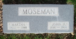
| Description | : | Name on Tombstone = Louise W. Moseman Dates on Tombstone = 12 Aug 1908 - 16 Nov 1909 Parents = John & Meta (Rudebusch) Moseman Obituary The Hooper Sentinel November 25, 1909 Mr. and Mrs. John Moseman, north of town, are sorrowing over the loss of one of their little twins, Louise, aged 1 year and 3 months. The little one was sick only half an hour, suffering with cramps. The funeral was held at the German Lutheran church, Rev. H. C. Julius Frese, preaching the sermon. Mr. and Mrs. Moseman have the sympathy of the entire community. |
frequently asked questions (FAQ):
-
Where is Louise W. Moseman's memorial?
Louise W. Moseman's memorial is located at: Hoddesdon Cemetery, Hoddesdon, Broxbourne Borough, England.
-
When did Louise W. Moseman death?
Louise W. Moseman death on 16 Nov 1909 in Hooper, Dodge County, Nebraska, USA
-
Where are the coordinates of the Louise W. Moseman's memorial?
Latitude: 51.7711490
Longitude: -0.0156822
Family Members:
Parent

Siblings
Flowers:


Nearby Cemetories:
1. Hoddesdon Cemetery
Hoddesdon, Broxbourne Borough, England
Coordinate: 51.7711490, -0.0156822
2. Woollensbrook Crematorium
Hoddesdon, Broxbourne Borough, England
Coordinate: 51.7681805, -0.0280669
3. St Catherine and St Paul's Churchyard
Hoddesdon, Broxbourne Borough, England
Coordinate: 51.7625830, -0.0120670
4. Quaker Burial Ground, Hoddesdon, Hertfordshire
Hoddesdon, Broxbourne Borough, England
Coordinate: 51.7610213, -0.0139560
5. St. Margaret's Parish Churchyard
Stanstead St Margarets, East Hertfordshire District, England
Coordinate: 51.7857570, -0.0002631
6. Holy Trinity Churchyard
Hertford Heath, East Hertfordshire District, England
Coordinate: 51.7865300, -0.0433980
7. St John the Baptist Churchyard
Great Amwell, East Hertfordshire District, England
Coordinate: 51.7944320, -0.0123740
8. Saint Augustine's Churchyard
Broxbourne, Broxbourne Borough, England
Coordinate: 51.7445150, -0.0147810
9. St James' Churchyard
Stanstead Abbotts, East Hertfordshire District, England
Coordinate: 51.7806920, 0.0275950
10. Roydon United Reform Churchyard
Roydon, Epping Forest District, England
Coordinate: 51.7714050, 0.0460240
11. St. Laurence Churchyard
Wormley, Broxbourne Borough, England
Coordinate: 51.7352050, -0.0389350
12. Saint Mary's Churchyard
Ware, East Hertfordshire District, England
Coordinate: 51.8120500, -0.0331800
13. All Saints with Saint John Churchyard
Hertford, East Hertfordshire District, England
Coordinate: 51.7950040, -0.0757330
14. The Immaculate Conception and St Joseph
Hertford, East Hertfordshire District, England
Coordinate: 51.7988966, -0.0745293
15. All Saints Churchyard
Nazeing, Epping Forest District, England
Coordinate: 51.7436140, 0.0464100
16. Saint Andrew Churchyard
Hertford, East Hertfordshire District, England
Coordinate: 51.7960550, -0.0823520
17. Ware Cemetery Old
Ware, East Hertfordshire District, England
Coordinate: 51.8170650, -0.0433230
18. St. Leonard's Churchyard
Bengeo, East Hertfordshire District, England
Coordinate: 51.8055165, -0.0722084
19. St. Dunstan Churchyard
Hunsdon, East Hertfordshire District, England
Coordinate: 51.7951000, 0.0548190
20. Ware Cemetery New
Ware, East Hertfordshire District, England
Coordinate: 51.8181400, -0.0438590
21. Holy Trinity Churchyard
Bengeo, East Hertfordshire District, England
Coordinate: 51.8053500, -0.0798610
22. Saint Mary
Bayford, East Hertfordshire District, England
Coordinate: 51.7629540, -0.1035070
23. Holy Trinity Churchyard
Wareside, East Hertfordshire District, England
Coordinate: 51.8212430, 0.0221440
24. St Mary the Virgin Churchyard
Great Parndon, Harlow District, England
Coordinate: 51.7605100, 0.0739860