

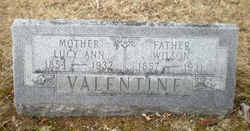
Lucy Ann Noggle Valentine
| Birth | : | 28 Jan 1854 Fairfield County, Ohio, USA |
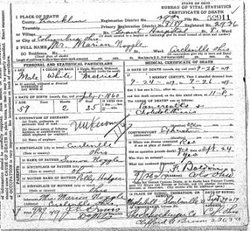
| Death | : | 28 Feb 1932 Columbus, Franklin County, Ohio, USA |
| Burial | : | Kingsway Old Cemetery, Kirkby-in-Ashfield, Ashfield District, England |
| Coordinate | : | 53.0936690, -1.2427970 |
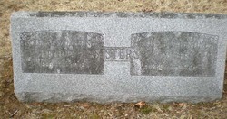
| Inscription | : | wife of W., 1854-1932 |
| Description | : | Lucy Ann Noggle was born January 28, 1854, in Clear Creek Township, Fairfield County, Ohio, the daughter of Simon and Polly Hedges Noggle. On November 7, 1878, she married Wilson Valentine, son of Noah and Mary Elizabeth Conrad Valentine, in Stoutsville, Fairfield County, Ohio. They were the parents of 8 children: a son who died young, Rose Etta, Ollie Ethel, Elmer Clayton, Durbin L., Bertha E., Oscar Allen and Ralph W. Valentine. Lucy Ann passed away February 28, 1932, in Columbus, Franklin County, Ohio, and was buried on March 1st in Maple Hill Cemetery, Stoutsville. From the Ohio... Read More |
frequently asked questions (FAQ):
-
Where is Lucy Ann Noggle Valentine's memorial?
Lucy Ann Noggle Valentine's memorial is located at: Kingsway Old Cemetery, Kirkby-in-Ashfield, Ashfield District, England.
-
When did Lucy Ann Noggle Valentine death?
Lucy Ann Noggle Valentine death on 28 Feb 1932 in Columbus, Franklin County, Ohio, USA
-
Where are the coordinates of the Lucy Ann Noggle Valentine's memorial?
Latitude: 53.0936690
Longitude: -1.2427970
Family Members:
Parent

Spouse
Siblings
Children

Flowers:


Nearby Cemetories:
1. Kingsway Old Cemetery
Kirkby-in-Ashfield, Ashfield District, England
Coordinate: 53.0936690, -1.2427970
2. Kingsway New Cemetery
Kirkby-in-Ashfield, Ashfield District, England
Coordinate: 53.0917070, -1.2422500
3. St. Wilfrid's Churchyard Extension
Kirkby-in-Ashfield, Ashfield District, England
Coordinate: 53.0975000, -1.2693400
4. Annesley and Felley
Annesley, Ashfield District, England
Coordinate: 53.0771910, -1.2407140
5. St. Mary the Virgin Churchyard
Newstead, Gedling Borough, England
Coordinate: 53.0688200, -1.2273000
6. All Saints Churchyard
Annesley, Ashfield District, England
Coordinate: 53.0662300, -1.2501190
7. Newstead Hucknall Road Cemetery
Newstead, Gedling Borough, England
Coordinate: 53.0651470, -1.2298350
8. Newstead Abbey
Newstead, Gedling Borough, England
Coordinate: 53.0783450, -1.1931120
9. Sutton Cemetery
Sutton-in-Ashfield, Ashfield District, England
Coordinate: 53.1238890, -1.2714690
10. St. Mary Magdalene Churchyard
Sutton-in-Ashfield, Ashfield District, England
Coordinate: 53.1255500, -1.2700820
11. Mansfield Crematorium
Mansfield, Mansfield District, England
Coordinate: 53.1214230, -1.1946980
12. Mansfield Cemetery
Mansfield, Mansfield District, England
Coordinate: 53.1250960, -1.1934520
13. Nottingham Road Cemetery
Mansfield, Mansfield District, England
Coordinate: 53.1270400, -1.1920500
14. St. James Churchyard
Papplewick, Gedling Borough, England
Coordinate: 53.0582060, -1.1872990
15. St. Helen's Churchyard
Pinxton, Bolsover District, England
Coordinate: 53.0904510, -1.3243570
16. Saint Andrew's Parish Churchyard
Skegby, Ashfield District, England
Coordinate: 53.1429900, -1.2661100
17. St. Peter's Churchyard
Mansfield, Mansfield District, England
Coordinate: 53.1434700, -1.1928900
18. St. Mary Magdalene Churchyard
Hucknall, Ashfield District, England
Coordinate: 53.0390630, -1.2058330
19. St. Michael and All Angels Churchyard
South Normanton, Bolsover District, England
Coordinate: 53.1091020, -1.3411800
20. St. Werburgh's Churchyard
Blackwell, Bolsover District, England
Coordinate: 53.1209850, -1.3380680
21. St. Mary's Churchyard
Jacksdale, Ashfield District, England
Coordinate: 53.0577660, -1.3326300
22. Hucknall Cemetery
Hucknall, Ashfield District, England
Coordinate: 53.0293427, -1.1988190
23. St Mary of the Purification Churchyard
Blidworth, Newark and Sherwood District, England
Coordinate: 53.0946620, -1.1269380
24. Christ Church Churchyard
Ironville, Amber Valley Borough, England
Coordinate: 53.0628250, -1.3508600