
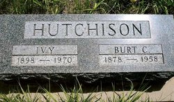
Mabel Ivy Burley Hutchison
| Birth | : | 31 Jan 1898 Colorado, USA |
| Death | : | 9 May 1970 Valentine, Cherry County, Nebraska, USA |
| Burial | : | St Peter & Paul Churchyard, Preston, Rutland Unitary Authority, England |
| Coordinate | : | 52.6122600, -0.7162560 |
| Description | : | MRS. IVY HUTCHISON Mrs. Ivy Hutchison died at the Sandhills Hospital in Valentine on May 9, 1970 at the age of 72 years. Services were conducted May 13, 1970 at 3:00 p.m. at the Watts Mortuary in Valentine with Rev. Lee Hicks officiating. Burial was in the Norden Cemetery. Mabel Ivy Burley Hutchison was born January 31, 1898 in Colorado. In 1919 on October 8th she was untied in marriage to Burton Calvin Hutchison at Ainsworth, Nebraska. Preceeding her in death were her husband. Survivors include: daughters Mrs. Henry Studeny of Valentine, Mrs. Gladys Stanberry of Sylmar, California; son Burton Hutchison of Dallas,... Read More |
frequently asked questions (FAQ):
-
Where is Mabel Ivy Burley Hutchison's memorial?
Mabel Ivy Burley Hutchison's memorial is located at: St Peter & Paul Churchyard, Preston, Rutland Unitary Authority, England.
-
When did Mabel Ivy Burley Hutchison death?
Mabel Ivy Burley Hutchison death on 9 May 1970 in Valentine, Cherry County, Nebraska, USA
-
Where are the coordinates of the Mabel Ivy Burley Hutchison's memorial?
Latitude: 52.6122600
Longitude: -0.7162560
Family Members:
Parent
Spouse

Siblings


Children
Flowers:


Nearby Cemetories:
1. St Peter & Paul Churchyard
Preston, Rutland Unitary Authority, England
Coordinate: 52.6122600, -0.7162560
2. St. Mary the Virgin Churchyard
Uppingham, Rutland Unitary Authority, England
Coordinate: 52.5996800, -0.7324400
3. Leicester Road Cemetery
Uppingham, Rutland Unitary Authority, England
Coordinate: 52.5975766, -0.7413414
4. St. Peter and St. Paul's Churchyard
Wing, Rutland Unitary Authority, England
Coordinate: 52.6172140, -0.6814150
5. St. Peter and St. Paul's Churchyard
Uppingham, Rutland Unitary Authority, England
Coordinate: 52.5873820, -0.7221660
6. Uppingham Lawn Cemetery
Uppingham, Rutland Unitary Authority, England
Coordinate: 52.5855800, -0.7229700
7. St. Andrew's Churchyard
Glaston, Rutland Unitary Authority, England
Coordinate: 52.5953628, -0.6781534
8. St Nicholas Churchyard
Pilton, Rutland Unitary Authority, England
Coordinate: 52.6165200, -0.6504100
9. All Hallows Churchyard
Seaton, Rutland Unitary Authority, England
Coordinate: 52.5745730, -0.6670810
10. St Peter Churchyard
Belton, Rutland Unitary Authority, England
Coordinate: 52.6038200, -0.7957000
11. St Mary the Virgin Churchyard
Morcott, Rutland Unitary Authority, England
Coordinate: 52.5967800, -0.6366200
12. St Andrew Churchyard
Stoke Dry, Rutland Unitary Authority, England
Coordinate: 52.5620632, -0.7394099
13. St Andrew Churchyard
Hambleton, Rutland Unitary Authority, England
Coordinate: 52.6585060, -0.6712280
14. St. Peter's Churchyard
Stockerston, Harborough District, England
Coordinate: 52.5687800, -0.7706600
15. St Mary the Virgin Churchyard
Edith Weston, Rutland Unitary Authority, England
Coordinate: 52.6379100, -0.6311100
16. St. John The Baptist Church
North Luffenham, Rutland Unitary Authority, England
Coordinate: 52.6186570, -0.6211140
17. Saint John The Baptist Churchyard
Harringworth, East Northamptonshire Borough, England
Coordinate: 52.5671000, -0.6491000
18. St Mary the Virgin Churchyard
South Luffenham, Rutland Unitary Authority, England
Coordinate: 52.6067200, -0.6114100
19. Oakham Cemetery
Oakham, Rutland Unitary Authority, England
Coordinate: 52.6768700, -0.7297400
20. Launde Abbey
Launde, Harborough District, England
Coordinate: 52.6313950, -0.8233060
21. St. Peter's Churchyard
Barrowden, Rutland Unitary Authority, England
Coordinate: 52.5888800, -0.6063600
22. Withcote Chapel
Harborough District, England
Coordinate: 52.6440500, -0.8253346
23. St. James Churchyard
Gretton, Corby Borough, England
Coordinate: 52.5403000, -0.6763400
24. St. John the Evangelist Churchyard
Caldecott, Rutland Unitary Authority, England
Coordinate: 52.5341600, -0.7213400