

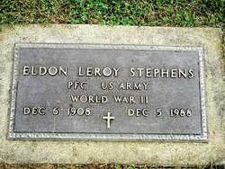
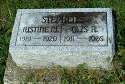
Maggie May Swing Stephens
| Birth | : | 9 Jul 1881 Indiana, USA |
| Death | : | 5 Jul 1953 Roanoke, Huntington County, Indiana, USA |
| Burial | : | Mother Of God Cemetery, Kenton Vale, Kenton County, USA |
| Coordinate | : | 39.0480995, -84.5171967 |
| Plot | : | L 3 |
frequently asked questions (FAQ):
-
Where is Maggie May Swing Stephens's memorial?
Maggie May Swing Stephens's memorial is located at: Mother Of God Cemetery, Kenton Vale, Kenton County, USA.
-
When did Maggie May Swing Stephens death?
Maggie May Swing Stephens death on 5 Jul 1953 in Roanoke, Huntington County, Indiana, USA
-
Where are the coordinates of the Maggie May Swing Stephens's memorial?
Latitude: 39.0480995
Longitude: -84.5171967
Family Members:
Parent
Spouse
Siblings

Children


Nearby Cemetories:
1. Mother Of God Cemetery
Kenton Vale, Kenton County, USA
Coordinate: 39.0480995, -84.5171967
2. Buena Vista Cemetery
Covington, Kenton County, USA
Coordinate: 39.0595200, -84.5040000
3. Sisters of Notre Dame Cemetery
Park Hills, Kenton County, USA
Coordinate: 39.0637530, -84.5303120
4. Highland Cemetery
Fort Mitchell, Kenton County, USA
Coordinate: 39.0475006, -84.5457993
5. Saint John German Protestant Cemetery
Wilder, Campbell County, USA
Coordinate: 39.0478440, -84.4854430
6. Northern Kentucky Police K-9 Memorial
Fort Mitchell, Kenton County, USA
Coordinate: 39.0387149, -84.5476438
7. Holy Guardian Angels Cemetery
Edgewood, Kenton County, USA
Coordinate: 39.0269444, -84.5358330
8. Saint Josephs Cemetery
Wilder, Campbell County, USA
Coordinate: 39.0469017, -84.4841995
9. Saint Mary's Cemetery
Fort Mitchell, Kenton County, USA
Coordinate: 39.0438995, -84.5500031
10. Linden Grove Cemetery
Covington, Kenton County, USA
Coordinate: 39.0738983, -84.5152969
11. Highland Pet Cemetery
Fort Mitchell, Kenton County, USA
Coordinate: 39.0384507, -84.5483047
12. Cathedral Basilica of the Assumption
Covington, Kenton County, USA
Coordinate: 39.0781120, -84.5081700
13. Webb Cemetery
Sunny Acres, Kenton County, USA
Coordinate: 39.0185470, -84.5035620
14. Saint John Cemetery
Fort Mitchell, Kenton County, USA
Coordinate: 39.0619011, -84.5550003
15. Saint Johns Cemetery
Wilder, Campbell County, USA
Coordinate: 39.0347170, -84.4750830
16. Craig Street Burying Ground
Covington, Kenton County, USA
Coordinate: 39.0840890, -84.5151330
17. Mother of God Church
Covington, Kenton County, USA
Coordinate: 39.0839600, -84.5125700
18. LaBare Cemetery
Crescent Springs, Kenton County, USA
Coordinate: 39.0631570, -84.5596300
19. Montague Cemetery
Covington, Kenton County, USA
Coordinate: 39.0805560, -84.5380550
20. Wilson Cemetery
Covington, Kenton County, USA
Coordinate: 39.0786110, -84.5438900
21. Johns Hill Cemetery
Wilder, Campbell County, USA
Coordinate: 39.0299988, -84.4738998
22. Evergreen Cemetery
Southgate, Campbell County, USA
Coordinate: 39.0667000, -84.4721985
23. Trinity Episcopal Church Memorial Garden
Covington, Kenton County, USA
Coordinate: 39.0873540, -84.5106140
24. Dedman Cemetery
Covington, Kenton County, USA
Coordinate: 39.0080560, -84.5294440