
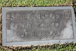
| Birth | : | 4 Oct 1911 Pitt County, North Carolina, USA |
| Death | : | 21 Jul 1988 Johnston County, North Carolina, USA |
| Burial | : | Kidlington Burial Ground, Kidlington, Cherwell District, England |
| Coordinate | : | 51.8266010, -1.2916660 |
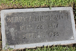
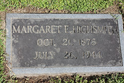
| Description | : | Daughter of Berry Alphonso Highsmith (1877-1938) and his wife Margaret E. Overton (1878-1944) of Pitt County, NC. Wife of James Hector Langdon (1908-1976). Margaret Elizabeth Highsmith married James Hector Langdon on September 29, 1935 in Pitt County, NC. James Hector Langdon was the son of Grover Cleveland Langdon (1884-1965) and his wife Mittie Catherine "Kittie" Stephenson (1888-1937) of Harnett County, NC. |
frequently asked questions (FAQ):
-
Where is Margaret Elizabeth Highsmith Langdon's memorial?
Margaret Elizabeth Highsmith Langdon's memorial is located at: Kidlington Burial Ground, Kidlington, Cherwell District, England.
-
When did Margaret Elizabeth Highsmith Langdon death?
Margaret Elizabeth Highsmith Langdon death on 21 Jul 1988 in Johnston County, North Carolina, USA
-
Where are the coordinates of the Margaret Elizabeth Highsmith Langdon's memorial?
Latitude: 51.8266010
Longitude: -1.2916660
Family Members:
Parent
Spouse
Siblings

Children
Flowers:


Nearby Cemetories:
1. Kidlington Burial Ground
Kidlington, Cherwell District, England
Coordinate: 51.8266010, -1.2916660
2. St Mary the Virgin Churchyard
Kidlington, Cherwell District, England
Coordinate: 51.8296680, -1.2797360
3. St Mary the Virgin Churchyard
Hampton Poyle, Cherwell District, England
Coordinate: 51.8359630, -1.2780620
4. St Giles Churchyard
Shipton-on-Cherwell, Cherwell District, England
Coordinate: 51.8444550, -1.2981890
5. St. Michael's Churchyard
Begbroke, Cherwell District, England
Coordinate: 51.8221520, -1.3218069
6. Holy Cross Churchyard
Shipton-on-Cherwell, Cherwell District, England
Coordinate: 51.8452170, -1.3043260
7. St. Bartholomew's Churchyard
Yarnton, Cherwell District, England
Coordinate: 51.8016610, -1.3087620
8. Yarnton Cemetery
Yarnton, Cherwell District, England
Coordinate: 51.8004080, -1.3103260
9. St. Nicholas' Churchyard
Islip, Cherwell District, England
Coordinate: 51.8230010, -1.2375590
10. St Giles Churchyard and Extension
Bletchingdon, Cherwell District, England
Coordinate: 51.8582500, -1.2655500
11. St. Martin's Churchyard
Bladon, West Oxfordshire District, England
Coordinate: 51.8304596, -1.3495430
12. Wolvercote Cemetery
Oxford, City of Oxford, England
Coordinate: 51.7913666, -1.2721500
13. Hensington Road Cemetery
Woodstock, West Oxfordshire District, England
Coordinate: 51.8488700, -1.3495500
14. St. Peter Churchyard
Wolvercote, City of Oxford, England
Coordinate: 51.7848300, -1.2811100
15. North Oxfordshire Memorial Park and Crematorium
Tackley, West Oxfordshire District, England
Coordinate: 51.8647410, -1.3312160
16. St Mary Magdalene Churchyard
Woodstock, West Oxfordshire District, England
Coordinate: 51.8472890, -1.3569480
17. Blenheim Palace
Woodstock, West Oxfordshire District, England
Coordinate: 51.8414993, -1.3611000
18. Lawn Cemetery
Woodstock, West Oxfordshire District, England
Coordinate: 51.8534220, -1.3512110
19. St Peter's Churchyard
Cassington, West Oxfordshire District, England
Coordinate: 51.7923610, -1.3423160
20. St Mary the Virgin Churchyard
Kirtlington, Cherwell District, England
Coordinate: 51.8718610, -1.2742740
21. Woodeaton Holy Rood Churchyard
Woodeaton, South Oxfordshire District, England
Coordinate: 51.8031620, -1.2257910
22. Godstow Abbey Ruins
Oxford, City of Oxford, England
Coordinate: 51.7784060, -1.2998170
23. St Michael and All Angels Summertown
Oxford, City of Oxford, England
Coordinate: 51.7796280, -1.2643940
24. St Giles Churchyard
Noke, Cherwell District, England
Coordinate: 51.8145050, -1.2114790