
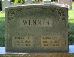
Margaret Jeanette Wenner
| Birth | : | 15 Dec 1866 |
| Death | : | 7 Jan 1948 Lovettsville, Loudoun County, Virginia, USA |
| Burial | : | Bainbridge Cemetery, Bainbridge, Richmondshire District, England |
| Coordinate | : | 54.3054000, -2.0994100 |
| Description | : | Mrs. Margaret Jeanette Wenner, 82, died of a heart attack at the home of her daughter, Mrs. Claude Spring, in Lovettsville, VA. Services to be conducted at the Taylorstown Mt. Pleasant Methodist Church, with interment in the church cemetery. Parents: John Davis and Canelia Filler Davis Married: Robert J. Wenner (dec'd.) Children: Mrs. Simon Coates Mrs. Claude Spring Roscoe Wenner Robert Wenner Raymond Wenner Glendon Wenner 6 Grandchildren 5 G-Grandchildren |
frequently asked questions (FAQ):
-
Where is Margaret Jeanette Wenner's memorial?
Margaret Jeanette Wenner's memorial is located at: Bainbridge Cemetery, Bainbridge, Richmondshire District, England.
-
When did Margaret Jeanette Wenner death?
Margaret Jeanette Wenner death on 7 Jan 1948 in Lovettsville, Loudoun County, Virginia, USA
-
Where are the coordinates of the Margaret Jeanette Wenner's memorial?
Latitude: 54.3054000
Longitude: -2.0994100
Family Members:
Spouse

Children

Flowers:


Nearby Cemetories:
1. Bainbridge Cemetery
Bainbridge, Richmondshire District, England
Coordinate: 54.3054000, -2.0994100
2. Friends Burial Ground
Bainbridge, Richmondshire District, England
Coordinate: 54.3093330, -2.1023380
3. Askrigg Cemetery
Askrigg, Richmondshire District, England
Coordinate: 54.3141230, -2.0915060
4. St. Oswald Churchyard
Askrigg, Richmondshire District, England
Coordinate: 54.3147100, -2.0817500
5. St Matthew Old Churchyard
Stalling Busk, Richmondshire District, England
Coordinate: 54.2695500, -2.1289300
6. St Matthew Churchyard
Stalling Busk, Richmondshire District, England
Coordinate: 54.2686220, -2.1302030
7. Friends Burial Ground
Hawes, Richmondshire District, England
Coordinate: 54.3039790, -2.1937940
8. St. Margaret's Churchyard
Hawes, Richmondshire District, England
Coordinate: 54.3032300, -2.1969700
9. Sandemanian Chapel Burial Ground
Hawes, Richmondshire District, England
Coordinate: 54.2992110, -2.1982010
10. Friends Meeting House Burial Ground
Carperby, Richmondshire District, England
Coordinate: 54.3031720, -1.9925670
11. St. Mary and St. John Churchyard
Hardraw, Richmondshire District, England
Coordinate: 54.3169800, -2.2052700
12. St. Andrew Churchyard
Aysgarth, Richmondshire District, England
Coordinate: 54.2922340, -1.9833760
13. Gunnerside Wesleyan Methodist Chapelyard
Gunnerside, Richmondshire District, England
Coordinate: 54.3783950, -2.0778320
14. St. Mary's Churchyard
Muker, Richmondshire District, England
Coordinate: 54.3763690, -2.1392860
15. Low Row United Reformed Chapelyard
Low Row, Richmondshire District, England
Coordinate: 54.3755880, -2.0317420
16. Low Row Methodist Cemetery
Low Row, Richmondshire District, England
Coordinate: 54.3798050, -2.0259320
17. Holy Trinity Churchyard
Low Row, Richmondshire District, England
Coordinate: 54.3812800, -2.0223090
18. St Mary Churchyard
Redmire, Richmondshire District, England
Coordinate: 54.3126200, -1.9227400
19. St. Michael and All Angels Churchyard
Hubberholme, Craven District, England
Coordinate: 54.2001100, -2.1147330
20. Keld United Reform Chapelyard
Keld, Richmondshire District, England
Coordinate: 54.4055920, -2.1660210
21. St Bartholomew Churchyard
West Witton, Richmondshire District, England
Coordinate: 54.2920100, -1.9073200
22. Preston Under Scar Cemetery
Preston-under-Scar, Richmondshire District, England
Coordinate: 54.3133800, -1.8964000
23. Reeth Congregational Chapelyard
Reeth, Richmondshire District, England
Coordinate: 54.3878600, -1.9422700
24. St. Andrew's Churchyard
Grinton, Richmondshire District, England
Coordinate: 54.3812610, -1.9305740