
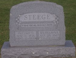

Marie Louise Wilhelmina “Minnie” Mohling Steege
| Birth | : | 28 Jul 1867 Iowa, USA |
| Death | : | 26 Feb 1946 Westgate, Fayette County, Iowa, USA |
| Burial | : | Lehigh Cemetery, Lehigh, Coal County, USA |
| Coordinate | : | 34.4775900, -96.2319400 |
frequently asked questions (FAQ):
-
Where is Marie Louise Wilhelmina “Minnie” Mohling Steege's memorial?
Marie Louise Wilhelmina “Minnie” Mohling Steege's memorial is located at: Lehigh Cemetery, Lehigh, Coal County, USA.
-
When did Marie Louise Wilhelmina “Minnie” Mohling Steege death?
Marie Louise Wilhelmina “Minnie” Mohling Steege death on 26 Feb 1946 in Westgate, Fayette County, Iowa, USA
-
Where are the coordinates of the Marie Louise Wilhelmina “Minnie” Mohling Steege's memorial?
Latitude: 34.4775900
Longitude: -96.2319400
Family Members:
Parent

Spouse

Siblings
Children
Flowers:


Nearby Cemetories:
1. Lehigh Cemetery
Lehigh, Coal County, USA
Coordinate: 34.4775900, -96.2319400
2. Old Lehigh Cemetery
Lehigh, Coal County, USA
Coordinate: 34.4435997, -96.2164001
3. Calvary Cemetery
Phillips, Coal County, USA
Coordinate: 34.5121994, -96.2136002
4. Midway Cemetery
Lehigh, Coal County, USA
Coordinate: 34.4402800, -96.2081200
5. Woodman Cemetery
Coalgate, Coal County, USA
Coordinate: 34.5341988, -96.1996994
6. Sealy Cemetery
Coal County, USA
Coordinate: 34.4775009, -96.3202972
7. Valley View Cemetery
Atoka County, USA
Coordinate: 34.4068985, -96.2632980
8. Davis Cemetery
Coal County, USA
Coordinate: 34.4860992, -96.3321991
9. Macedonia Cemetery
Atoka, Atoka County, USA
Coordinate: 34.4350000, -96.1447300
10. Coalgate Cemetery
Coalgate, Coal County, USA
Coordinate: 34.5628014, -96.2155991
11. Coal Creek Cemetery
Atoka, Atoka County, USA
Coordinate: 34.4563889, -96.1286111
12. Nixon Cemetery
Coalgate, Coal County, USA
Coordinate: 34.5345150, -96.3253070
13. Whitehall Cemetery
Atoka County, USA
Coordinate: 34.4166985, -96.3230972
14. Standing Rock Cemetery
Atoka County, USA
Coordinate: 34.3863983, -96.2810974
15. Green Meadows Cemetery
Atoka, Atoka County, USA
Coordinate: 34.3983700, -96.1455630
16. Plainview Cemetery
Atoka County, USA
Coordinate: 34.3717003, -96.2118988
17. Wards Chapel Cemetery
Atoka, Atoka County, USA
Coordinate: 34.3675003, -96.2497025
18. Keel Family Cemetery
Coal County, USA
Coordinate: 34.5064011, -96.3703003
19. Confederate Cemetery
Atoka, Atoka County, USA
Coordinate: 34.3983002, -96.1164017
20. Westview Cemetery
Atoka, Atoka County, USA
Coordinate: 34.3838420, -96.1331060
21. Boggy Bend Cemetery
Stringtown, Atoka County, USA
Coordinate: 34.4955556, -96.0775000
22. James Family Cemetery
Olney, Coal County, USA
Coordinate: 34.4617100, -96.3872100
23. B Street Catholic Churchyard
Atoka, Atoka County, USA
Coordinate: 34.3863090, -96.1211550
24. B Street Cemetery
Atoka, Atoka County, USA
Coordinate: 34.3853615, -96.1194889