
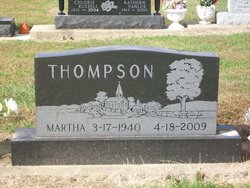
Martha Ann Brown Thompson
| Birth | : | 17 Mar 1940 Rochester, Fulton County, Indiana, USA |
| Death | : | 18 Apr 2009 Plymouth, Marshall County, Indiana, USA |
| Burial | : | Friendship Cemetery, Friendship, Crockett County, USA |
| Coordinate | : | 35.9146430, -89.2381450 |
| Plot | : | Section 19, Row 1 |
| Description | : | Published in the Rochester(IN) Sentinel, Monday, April 20, 2009 Martha A. Thompson, March 17, 1940-April 18, 2009, Martha A. Thompson, 69, died at her residence at 3:14 a.m. Saturday. She had lived all of her life in the Plymouth, Rochester, Akron and Mentone areas. She was born in Rochester, the daughter of Orlo M. and Alta Foor Brown, on March 17, 1940. She graduated from Plymouth High School in 1958. In October of 1958, in Plymouth, she and Stuart Thompson were married. For over 40 years, Martha was a tax accountant. She loved to travel, especially on cruise... Read More |
frequently asked questions (FAQ):
-
Where is Martha Ann Brown Thompson's memorial?
Martha Ann Brown Thompson's memorial is located at: Friendship Cemetery, Friendship, Crockett County, USA.
-
When did Martha Ann Brown Thompson death?
Martha Ann Brown Thompson death on 18 Apr 2009 in Plymouth, Marshall County, Indiana, USA
-
Where are the coordinates of the Martha Ann Brown Thompson's memorial?
Latitude: 35.9146430
Longitude: -89.2381450
Family Members:
Parent

Children
Flowers:


Nearby Cemetories:
1. Friendship Cemetery
Friendship, Crockett County, USA
Coordinate: 35.9146430, -89.2381450
2. Bellevernon Cemetery
Friendship, Crockett County, USA
Coordinate: 35.9135830, -89.2495910
3. Bowen Chapel Cemetery
Friendship, Dyer County, USA
Coordinate: 35.9311810, -89.2353720
4. Mount Moriah Cemetery
Friendship, Crockett County, USA
Coordinate: 35.8955420, -89.2576300
5. Edwards Cemetery
Friendship, Crockett County, USA
Coordinate: 35.9314120, -89.2146810
6. Mount Zion Cemetery
Friendship, Crockett County, USA
Coordinate: 35.9131950, -89.2032590
7. Deaton Cemetery
Friendship, Crockett County, USA
Coordinate: 35.9350080, -89.2122640
8. Robertson-Warren Cemetery
Friendship, Crockett County, USA
Coordinate: 35.8830700, -89.2427200
9. Mose M. Thompson Cemetery
Friendship, Dyer County, USA
Coordinate: 35.9243680, -89.2765870
10. Hardin Cemetery
Friendship, Dyer County, USA
Coordinate: 35.9243270, -89.2766430
11. Nash Cemetery
Dyersburg, Dyer County, USA
Coordinate: 35.9252500, -89.2822230
12. Mays Chapel Cemetery
Friendship, Crockett County, USA
Coordinate: 35.9363540, -89.2006050
13. Old Dyer Church Cemetery
Friendship, Crockett County, USA
Coordinate: 35.8844600, -89.2101900
14. Allen Chapel Cemetery
Tigrett, Dyer County, USA
Coordinate: 35.9511400, -89.2207500
15. Hendrix Cemetery
Tigrett, Dyer County, USA
Coordinate: 35.9511500, -89.2206950
16. Williams Chapel Baptist Church Cemetery
Friendship, Crockett County, USA
Coordinate: 35.9258940, -89.1916320
17. Mount Pisgah Cemetery
Friendship, Dyer County, USA
Coordinate: 35.9162470, -89.2901740
18. Zion Hill Church Cemetery
Friendship, Dyer County, USA
Coordinate: 35.9095110, -89.2900760
19. Saint Peter Cemetery
Tigrett, Dyer County, USA
Coordinate: 35.9616440, -89.2520140
20. Staggs Cemetery
Friendship, Dyer County, USA
Coordinate: 35.9397930, -89.2896620
21. Jones Cemetery
Tigrett, Dyer County, USA
Coordinate: 35.9552230, -89.2747450
22. McGary Family Cemetery
Tigrett, Dyer County, USA
Coordinate: 35.9649530, -89.2501520
23. Browder Family Cemetery
Broadview, Crockett County, USA
Coordinate: 35.8646890, -89.2623010
24. Cock and Irvin Cemetery
Hawkinsville, Dyer County, USA
Coordinate: 35.9104430, -89.3046210