
| Birth | : | 24 Aug 1872 Tennessee, USA |
| Death | : | 3 Mar 1940 Tennessee, USA |
| Burial | : | Bethel Cemetery, Scotts Hill, Decatur County, USA |
| Coordinate | : | 35.4963690, -88.2320790 |
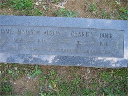
| Description | : | Married: Noah Flatt 8 Dec 1920 Decatur County, Tennessee D/O James Madison Austin and Charity Duck Tennessee Death Certificate Name: Lucinda Flatt Gender: Female Birth Date: 24 Aug 1872 Birth Place: Decatur, Tennessee Age: 67 Death Date: 3 Mar 1940 Death Place: Decatur, Tennessee Father's Name: James Austin Father's Birth Place: Tennessee Mother's name: Charity Duck Mother's Birth Place: Tennessee Certificate Number: 5980 |
frequently asked questions (FAQ):
-
Where is Martha Lucinda Austin Flatt's memorial?
Martha Lucinda Austin Flatt's memorial is located at: Bethel Cemetery, Scotts Hill, Decatur County, USA.
-
When did Martha Lucinda Austin Flatt death?
Martha Lucinda Austin Flatt death on 3 Mar 1940 in Tennessee, USA
-
Where are the coordinates of the Martha Lucinda Austin Flatt's memorial?
Latitude: 35.4963690
Longitude: -88.2320790
Family Members:
Parent

Spouse
Siblings

Flowers:


Nearby Cemetories:
1. Bethel Cemetery
Scotts Hill, Decatur County, USA
Coordinate: 35.4963690, -88.2320790
2. Scotts Hill Pentecostal Church Cemetery
Scotts Hill, Decatur County, USA
Coordinate: 35.5065610, -88.2336080
3. Grandsire Holmes Cemetery
Scotts Hill, Henderson County, USA
Coordinate: 35.5140820, -88.2483620
4. Fellowship Church Cemetery
Scotts Hill, Henderson County, USA
Coordinate: 35.4965940, -88.2602540
5. Scotts Hill Church Cemetery
Scotts Hill, Henderson County, USA
Coordinate: 35.5189480, -88.2463960
6. Peace Chapel Cemetery
Scotts Hill, Decatur County, USA
Coordinate: 35.5214060, -88.2206280
7. Doe Creek Cemetery
Scotts Hill, Henderson County, USA
Coordinate: 35.4692990, -88.2474350
8. Murphy Cemetery
Lick Skillet, Decatur County, USA
Coordinate: 35.4806930, -88.1983720
9. Decatur County Farm Cemetery
Scotts Hill, Decatur County, USA
Coordinate: 35.5078697, -88.1940994
10. Cedar Grove Cemetery
Henderson County, USA
Coordinate: 35.4799600, -88.2678900
11. Cedar Grove Pentecostal Cemetery
Sardis, Henderson County, USA
Coordinate: 35.4829530, -88.2698440
12. Granny Austin Cemetery
Scotts Hill, Henderson County, USA
Coordinate: 35.4949850, -88.2734300
13. Pafford - Scotts Hill Cemetery
Scotts Hill, Henderson County, USA
Coordinate: 35.5265450, -88.2515290
14. Martin Family Cemetery
Decaturville, Decatur County, USA
Coordinate: 35.5139160, -88.1882440
15. Crawford Cemetery
Scotts Hill, Decatur County, USA
Coordinate: 35.5141550, -88.1882830
16. Pratt Cemetery
Decaturville, Decatur County, USA
Coordinate: 35.5403540, -88.2231060
17. Morgan Family Cemetery
Decaturville, Decatur County, USA
Coordinate: 35.5343740, -88.1975940
18. Chumney Cemetery
Scotts Hill, Henderson County, USA
Coordinate: 35.5423140, -88.2460590
19. Prospect Church Cemetery
Sardis, Henderson County, USA
Coordinate: 35.4584950, -88.2683120
20. Flat Creek Cemetery
Scotts Hill, Decatur County, USA
Coordinate: 35.5450790, -88.2404150
21. Lowery-Doe Creek Cemetery
Decatur County, USA
Coordinate: 35.4483120, -88.2468900
22. Red Walnut Church Cemetery
Lick Skillet, Decatur County, USA
Coordinate: 35.4700840, -88.1787990
23. Liberty Church Cemetery
Scotts Hill, Decatur County, USA
Coordinate: 35.4466050, -88.2146570
24. Davis Cemetery
Decatur County, USA
Coordinate: 35.5374985, -88.1800003