
| Memorials | : | 10 |
| Location | : | Sardis, Henderson County, USA |
| Coordinate | : | 35.4584950, -88.2683120 |
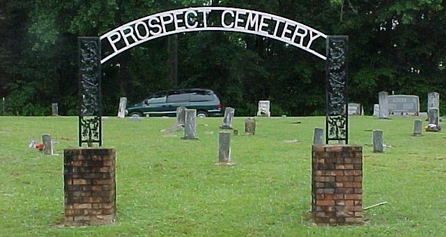
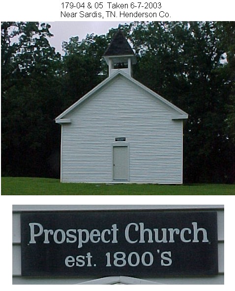
| Description | : | This cemetery is located on Presley Ridge Road, about a mile east of its intersection with Scotts Hill-Sardis Road. This cemetery is well maintained. By 1995 the cemetery was almost full, but by 2001 a new area was opened for use on the opposite side of the road, besides the old church building. |
frequently asked questions (FAQ):
-
Where is Prospect Church Cemetery?
Prospect Church Cemetery is located at Presley Ridge Road Sardis, Henderson County ,Tennessee ,USA.
-
Prospect Church Cemetery cemetery's updated grave count on graveviews.com?
10 memorials
-
Where are the coordinates of the Prospect Church Cemetery?
Latitude: 35.4584950
Longitude: -88.2683120
Nearby Cemetories:
1. Doe Creek Cemetery
Scotts Hill, Henderson County, USA
Coordinate: 35.4692990, -88.2474350
2. Lowery-Doe Creek Cemetery
Decatur County, USA
Coordinate: 35.4483120, -88.2468900
3. Cedar Grove Cemetery
Henderson County, USA
Coordinate: 35.4799600, -88.2678900
4. Cedar Grove Pentecostal Cemetery
Sardis, Henderson County, USA
Coordinate: 35.4829530, -88.2698440
5. Sardis Cemetery
Sardis, Henderson County, USA
Coordinate: 35.4366020, -88.2833100
6. Pleasant View Cemetery
Sardis, Henderson County, USA
Coordinate: 35.4639730, -88.3019970
7. Granny Austin Cemetery
Scotts Hill, Henderson County, USA
Coordinate: 35.4949850, -88.2734300
8. Fellowship Church Cemetery
Scotts Hill, Henderson County, USA
Coordinate: 35.4965940, -88.2602540
9. McBride Cemetery
Sardis, Henderson County, USA
Coordinate: 35.4406013, -88.3106003
10. Spring Hill Cemetery
Sardis, Henderson County, USA
Coordinate: 35.4277992, -88.3091965
11. Liberty Church Cemetery
Scotts Hill, Decatur County, USA
Coordinate: 35.4466050, -88.2146570
12. Bethel Cemetery
Scotts Hill, Decatur County, USA
Coordinate: 35.4963690, -88.2320790
13. Little Hurricane Cemetery
Sardis, Henderson County, USA
Coordinate: 35.4605060, -88.3302360
14. Scotts Hill Pentecostal Church Cemetery
Scotts Hill, Decatur County, USA
Coordinate: 35.5065610, -88.2336080
15. Grandsire Holmes Cemetery
Scotts Hill, Henderson County, USA
Coordinate: 35.5140820, -88.2483620
16. Patterson Cemetery
Lick Skillet, Decatur County, USA
Coordinate: 35.4383800, -88.1979020
17. Murphy Cemetery
Lick Skillet, Decatur County, USA
Coordinate: 35.4806930, -88.1983720
18. Scotts Hill Church Cemetery
Scotts Hill, Henderson County, USA
Coordinate: 35.5189480, -88.2463960
19. Hanna Cemetery
Hinkle, Hardin County, USA
Coordinate: 35.3991600, -88.3006680
20. Hurricane Church Cemetery
Hinkle, Hardin County, USA
Coordinate: 35.4080320, -88.3240380
21. Corinth Church Cemetery
Decatur County, USA
Coordinate: 35.4126020, -88.2056180
22. Pafford - Scotts Hill Cemetery
Scotts Hill, Henderson County, USA
Coordinate: 35.5265450, -88.2515290
23. Marl Bluff Cemetery
Sardis, Henderson County, USA
Coordinate: 35.4570870, -88.3561740
24. Red Walnut Church Cemetery
Lick Skillet, Decatur County, USA
Coordinate: 35.4700840, -88.1787990