
| Memorials | : | 21 |
| Location | : | Scotts Hill, Henderson County, USA |
| Coordinate | : | 35.4692990, -88.2474350 |
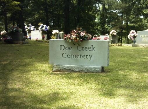
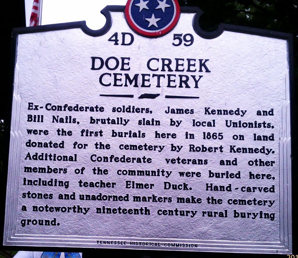
| Description | : | This cemetery is located on Doe Creek Road 3.8 miles south of Scotts Hill, and about 100 ft. west of the Decatur Co. line. It originated as a Kennedy family cemetery, created just after the Civil War, but later became a community church cemetery. The adjacent log church, later used as a school, is in ruins. The cemetery is very interesting. The core of the cemetery retains a nineteenth century appearance, even though the cemetery is still in use. There are rows of graves marked with fieldstone headstone and footstones. In most nineteenth century cemeteries, which are still in use,... Read More |
frequently asked questions (FAQ):
-
Where is Doe Creek Cemetery?
Doe Creek Cemetery is located at Doe Creek Rd Scotts Hill, Henderson County ,Tennessee ,USA.
-
Doe Creek Cemetery cemetery's updated grave count on graveviews.com?
21 memorials
-
Where are the coordinates of the Doe Creek Cemetery?
Latitude: 35.4692990
Longitude: -88.2474350
Nearby Cemetories:
1. Cedar Grove Cemetery
Henderson County, USA
Coordinate: 35.4799600, -88.2678900
2. Prospect Church Cemetery
Sardis, Henderson County, USA
Coordinate: 35.4584950, -88.2683120
3. Lowery-Doe Creek Cemetery
Decatur County, USA
Coordinate: 35.4483120, -88.2468900
4. Cedar Grove Pentecostal Cemetery
Sardis, Henderson County, USA
Coordinate: 35.4829530, -88.2698440
5. Fellowship Church Cemetery
Scotts Hill, Henderson County, USA
Coordinate: 35.4965940, -88.2602540
6. Bethel Cemetery
Scotts Hill, Decatur County, USA
Coordinate: 35.4963690, -88.2320790
7. Granny Austin Cemetery
Scotts Hill, Henderson County, USA
Coordinate: 35.4949850, -88.2734300
8. Liberty Church Cemetery
Scotts Hill, Decatur County, USA
Coordinate: 35.4466050, -88.2146570
9. Scotts Hill Pentecostal Church Cemetery
Scotts Hill, Decatur County, USA
Coordinate: 35.5065610, -88.2336080
10. Murphy Cemetery
Lick Skillet, Decatur County, USA
Coordinate: 35.4806930, -88.1983720
11. Sardis Cemetery
Sardis, Henderson County, USA
Coordinate: 35.4366020, -88.2833100
12. Pleasant View Cemetery
Sardis, Henderson County, USA
Coordinate: 35.4639730, -88.3019970
13. Grandsire Holmes Cemetery
Scotts Hill, Henderson County, USA
Coordinate: 35.5140820, -88.2483620
14. Scotts Hill Church Cemetery
Scotts Hill, Henderson County, USA
Coordinate: 35.5189480, -88.2463960
15. Patterson Cemetery
Lick Skillet, Decatur County, USA
Coordinate: 35.4383800, -88.1979020
16. Red Walnut Church Cemetery
Lick Skillet, Decatur County, USA
Coordinate: 35.4700840, -88.1787990
17. Peace Chapel Cemetery
Scotts Hill, Decatur County, USA
Coordinate: 35.5214060, -88.2206280
18. Pafford - Scotts Hill Cemetery
Scotts Hill, Henderson County, USA
Coordinate: 35.5265450, -88.2515290
19. Decatur County Farm Cemetery
Scotts Hill, Decatur County, USA
Coordinate: 35.5078697, -88.1940994
20. McBride Cemetery
Sardis, Henderson County, USA
Coordinate: 35.4406013, -88.3106003
21. Spring Hill Cemetery
Sardis, Henderson County, USA
Coordinate: 35.4277992, -88.3091965
22. Martin Family Cemetery
Decaturville, Decatur County, USA
Coordinate: 35.5139160, -88.1882440
23. Crawford Cemetery
Scotts Hill, Decatur County, USA
Coordinate: 35.5141550, -88.1882830
24. Corinth Church Cemetery
Decatur County, USA
Coordinate: 35.4126020, -88.2056180