
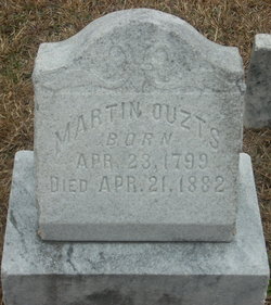
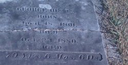
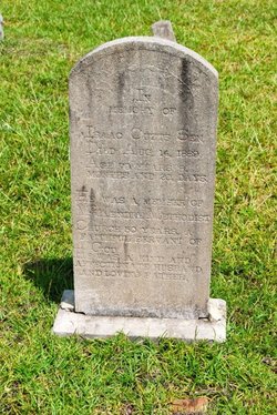
Martin Luther Ouzts
| Birth | : | 23 Apr 1799 Meeting Street, Edgefield County, South Carolina, USA |
| Death | : | 21 Apr 1882 Meeting Street, Edgefield County, South Carolina, USA |
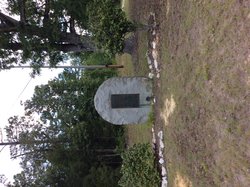
| Burial | : | Ryde Cemetery, Ryde, Isle of Wight Unitary Authority, England |
| Coordinate | : | 50.7249730, -1.1668550 |
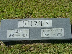
| Description | : | Martin Luther Ouzts is the seventh child of Elizabeth HARLING and George Peter Ouzts I of Hoffenheim Germany and Edgefied District, SC. Martin Luther Ouzts married Mary Catherine (Polly) STOTT, daughter of John Stott on January 4, 1824 in Edgefield County, SC. They had eleven children: Martha Ann, Benjamin Asberry (Berry), Abdel S., George Martin, Mary Ann, Frances A., John Henry, Margaret Henrietta, Joseph Allen, Hulda, and a daughter who died young, M. E. He is the Patriarch of the Martin Luther Ouzts Line. |
frequently asked questions (FAQ):
-
Where is Martin Luther Ouzts's memorial?
Martin Luther Ouzts's memorial is located at: Ryde Cemetery, Ryde, Isle of Wight Unitary Authority, England.
-
When did Martin Luther Ouzts death?
Martin Luther Ouzts death on 21 Apr 1882 in Meeting Street, Edgefield County, South Carolina, USA
-
Where are the coordinates of the Martin Luther Ouzts's memorial?
Latitude: 50.7249730
Longitude: -1.1668550
Family Members:
Parent

Spouse
Siblings
Children
Flowers:


Nearby Cemetories:
1. Ryde Cemetery
Ryde, Isle of Wight Unitary Authority, England
Coordinate: 50.7249730, -1.1668550
2. St Thomas Churchyard
Ryde, Isle of Wight Unitary Authority, England
Coordinate: 50.7305600, -1.1632540
3. Binstead Cemetery
Binstead, Isle of Wight Unitary Authority, England
Coordinate: 50.7264610, -1.1866180
4. St Cecilia's Abbey
Ryde, Isle of Wight Unitary Authority, England
Coordinate: 50.7279800, -1.1463120
5. Holy Cross Churchyard
Binstead, Isle of Wight Unitary Authority, England
Coordinate: 50.7320080, -1.1863070
6. St. Johns Churchyard
Ryde, Isle of Wight Unitary Authority, England
Coordinate: 50.7149770, -1.1482370
7. Quarr Old Abbey
Ryde, Isle of Wight Unitary Authority, England
Coordinate: 50.7310000, -1.1996000
8. Quarr Abbey
Binstead, Isle of Wight Unitary Authority, England
Coordinate: 50.7311862, -1.2034333
9. St Peter's
Havenstreet, Isle of Wight Unitary Authority, England
Coordinate: 50.7095580, -1.2063290
10. St. Edmund's Churchyard
Wootton, Isle of Wight Unitary Authority, England
Coordinate: 50.7308220, -1.2344490
11. St Mary the Virgin Churchyard
Brading, Isle of Wight Unitary Authority, England
Coordinate: 50.6824400, -1.1429600
12. Isle of Wight Crematorium
Whippingham, Isle of Wight Unitary Authority, England
Coordinate: 50.7217910, -1.2573910
13. St. Mark's Churchyard
Alverstoke, Gosport Borough, England
Coordinate: 50.7826800, -1.1436100
14. Clayhall Naval Cemetery
Gosport, Gosport Borough, England
Coordinate: 50.7833862, -1.1373420
15. Turkish Naval Cemetery
Gosport, Gosport Borough, England
Coordinate: 50.7840710, -1.1383980
16. St Mary Churchyard
Alverstoke, Gosport Borough, England
Coordinate: 50.7856760, -1.1480810
17. Lane End Cemetery
Bembridge, Isle of Wight Unitary Authority, England
Coordinate: 50.6863554, -1.0809575
18. St. Mildred's Churchyard
Whippingham, Isle of Wight Unitary Authority, England
Coordinate: 50.7398230, -1.2768350
19. Christ Churchyard
Sandown, Isle of Wight Unitary Authority, England
Coordinate: 50.6521319, -1.1621056
20. Portsmouth Naval Memorial
Portsmouth, Portsmouth Unitary Authority, England
Coordinate: 50.7824440, -1.0957720
21. Ann's Hill Cemetery
Gosport, Gosport Borough, England
Coordinate: 50.7982670, -1.1549450
22. Holy Trinity Churchyard
Gosport, Gosport Borough, England
Coordinate: 50.7930600, -1.1207620
23. Lake Cemetery
Lake, Isle of Wight Unitary Authority, England
Coordinate: 50.6498713, -1.1734786
24. Royal Garrison Church Churchyard
Plymouth, Plymouth Unitary Authority, England
Coordinate: 50.7889690, -1.1039650