
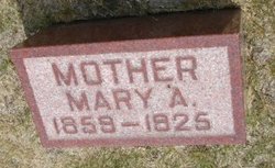
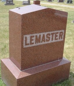
Mary Ann Temby LeMaster
| Birth | : | 12 Mar 1859 Wisconsin, USA |
| Death | : | 6 Jan 1925 Boone County, Iowa, USA |
| Burial | : | St. Andrew's Churchyard, Ashton-on-Ribble, City of Preston, England |
| Coordinate | : | 53.7687030, -2.7359180 |
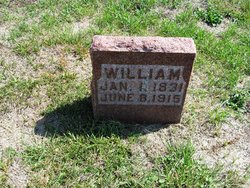
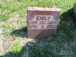
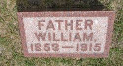
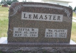
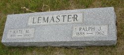
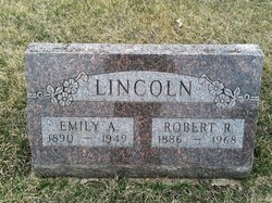
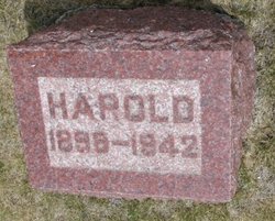
| Description | : | Daughter of William Temby (1831-1915) and Emily Treloar (1834-1908) Married William LeMaster in 1877 Children: Luellen Belle (1878-1949), William Floyd (1882-1965), Mary Edith (1885-1944), Ralph James (1888-1962), Emily Ada (1890-1949), John Harold (1898-1942) |
frequently asked questions (FAQ):
-
Where is Mary Ann Temby LeMaster's memorial?
Mary Ann Temby LeMaster's memorial is located at: St. Andrew's Churchyard, Ashton-on-Ribble, City of Preston, England.
-
When did Mary Ann Temby LeMaster death?
Mary Ann Temby LeMaster death on 6 Jan 1925 in Boone County, Iowa, USA
-
Where are the coordinates of the Mary Ann Temby LeMaster's memorial?
Latitude: 53.7687030
Longitude: -2.7359180
Family Members:
Parent
Spouse
Siblings

Children
Flowers:


Nearby Cemetories:
1. St. Andrew's Churchyard
Ashton-on-Ribble, City of Preston, England
Coordinate: 53.7687030, -2.7359180
2. St Walburge's RC Church
Preston, City of Preston, England
Coordinate: 53.7629690, -2.7149620
3. St Mary Churchyard
Penwortham, South Ribble Borough, England
Coordinate: 53.7551800, -2.7234210
4. Saint Peter Churchyard
Preston, City of Preston, England
Coordinate: 53.7634100, -2.7080700
5. Grey Friars' Church
Preston, City of Preston, England
Coordinate: 53.7601480, -2.7084600
6. Christ Church Churchyard
Preston, City of Preston, England
Coordinate: 53.7573210, -2.7103080
7. Holy Trinity
Preston, City of Preston, England
Coordinate: 53.7613030, -2.7030580
8. Friends Meeting House Burial Ground (Defunct)
Preston, City of Preston, England
Coordinate: 53.7610250, -2.7030380
9. Christ Church Churchyard
Fulwood, City of Preston, England
Coordinate: 53.7771920, -2.7028700
10. St. Wilfrid's Catholic Cemetery
Preston, City of Preston, England
Coordinate: 53.7581670, -2.7044930
11. St. George the Martyr
Preston, City of Preston, England
Coordinate: 53.7591220, -2.7025660
12. St Andrew George Haydock Roman Catholic Churchyard
Cottam, City of Preston, England
Coordinate: 53.7879280, -2.7591570
13. St. Ignatius RC Churchyard
Preston, City of Preston, England
Coordinate: 53.7635270, -2.6965870
14. Penwortham Cemetery
Penwortham, South Ribble Borough, England
Coordinate: 53.7452590, -2.7209190
15. St. Paul Churchyard
Preston, City of Preston, England
Coordinate: 53.7625360, -2.6947080
16. St John Churchyard
Preston, City of Preston, England
Coordinate: 53.7582080, -2.6959750
17. St. James' Churchyard
Preston, City of Preston, England
Coordinate: 53.7566010, -2.6941110
18. St Augustine of Canterbury
Preston, City of Preston, England
Coordinate: 53.7560420, -2.6912650
19. St. Mary's Churchyard
Lea, City of Preston, England
Coordinate: 53.7733810, -2.7942770
20. St. John Baptist Churchyard
Broughton-in-Amounderness, City of Preston, England
Coordinate: 53.8033700, -2.7170400
21. Saint Anne's Church
Woodplumpton, City of Preston, England
Coordinate: 53.8038130, -2.7621940
22. Preston Old Cemetery
Ribbleton, City of Preston, England
Coordinate: 53.7686352, -2.6623154
23. Preston New Cemetery
Ribbleton, City of Preston, England
Coordinate: 53.7717400, -2.6620900
24. St Leonard Churchyard
Walton-le-Dale, South Ribble Borough, England
Coordinate: 53.7476530, -2.6666950