
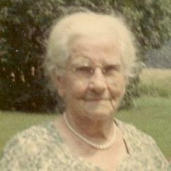
Mary Cecilia McFadden Rather
| Birth | : | 16 May 1880 Colora, Cecil County, Maryland, USA |
| Death | : | 22 Jun 1979 New Castle County, Delaware, USA |
| Burial | : | All Saints Churchyard, Newton-on-Ouse, Hambleton District, England |
| Coordinate | : | 54.0324800, -1.2210800 |
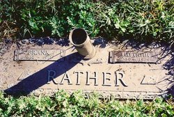
| Plot | : | Whispering Pines 24-D-2 |
frequently asked questions (FAQ):
-
Where is Mary Cecilia McFadden Rather's memorial?
Mary Cecilia McFadden Rather's memorial is located at: All Saints Churchyard, Newton-on-Ouse, Hambleton District, England.
-
When did Mary Cecilia McFadden Rather death?
Mary Cecilia McFadden Rather death on 22 Jun 1979 in New Castle County, Delaware, USA
-
Where are the coordinates of the Mary Cecilia McFadden Rather's memorial?
Latitude: 54.0324800
Longitude: -1.2210800
Family Members:
Parent

Spouse
Siblings
Children


Nearby Cemetories:
1. All Saints Churchyard
Newton-on-Ouse, Hambleton District, England
Coordinate: 54.0324800, -1.2210800
2. St Mary Priory Churchyard
Nun Monkton, Harrogate Borough, England
Coordinate: 54.0149100, -1.2212150
3. All Saints Churchyard
Moor Monkton, Harrogate Borough, England
Coordinate: 53.9976300, -1.2223700
4. Holy Evangelists Churchyard
Shipton, Hambleton District, England
Coordinate: 54.0234400, -1.1572300
5. St Stephen Churchyard
Aldwark, Hambleton District, England
Coordinate: 54.0640600, -1.2875000
6. St Mary Churchyard
Alne, Hambleton District, England
Coordinate: 54.0814400, -1.2438800
7. Holy Trinity Churchyard
Little Ouseburn, Harrogate Borough, England
Coordinate: 54.0440712, -1.3101200
8. St Thomas Churchyard
Green Hammerton, Harrogate Borough, England
Coordinate: 54.0055000, -1.3007000
9. St Mary the Virgin Churchyard
Great Ouseburn, Harrogate Borough, England
Coordinate: 54.0488052, -1.3125230
10. St John's the Baptist Church
Hessay, York Unitary Authority, England
Coordinate: 53.9767283, -1.2027246
11. St. John the Baptist Churchyard
Kirk Hammerton, Harrogate Borough, England
Coordinate: 53.9936690, -1.2918740
12. St. Giles' Churchyard
Skelton, York Unitary Authority, England
Coordinate: 54.0019111, -1.1342660
13. Moorlands Nature Reserve
Skelton, York Unitary Authority, England
Coordinate: 54.0226680, -1.1201180
14. Ascension Churchyard
Whixley, Harrogate Borough, England
Coordinate: 54.0186370, -1.3269930
15. Marston Moor Battlefield Burial Pits
Long Marston, Harrogate Borough, England
Coordinate: 53.9713910, -1.2578580
16. St Everilda Churchyard
Nether Poppleton, York Unitary Authority, England
Coordinate: 53.9882060, -1.1403710
17. Skelton Parish Council Cemetery
Skelton, York Unitary Authority, England
Coordinate: 54.0070970, -1.1150970
18. All Saints Churchyard
Upper Poppleton, York Unitary Authority, England
Coordinate: 53.9776970, -1.1510780
19. All Hallows Churchyard Extension Cemetery
Sutton-on-the-Forest, Hambleton District, England
Coordinate: 54.0757200, -1.1188700
20. St Mary Churchyard
Lower Dunsforth, Harrogate Borough, England
Coordinate: 54.0777130, -1.3241810
21. All Saints Churchyard
Rufforth, York Unitary Authority, England
Coordinate: 53.9568390, -1.1975690
22. All Hallows Churchyard
Sutton-on-the-Forest, Hambleton District, England
Coordinate: 54.0746800, -1.1103500
23. Church of the Epiphany Churchyard
Tockwith, Harrogate Borough, England
Coordinate: 53.9653480, -1.2909130
24. Wigginton Garden of Rest
Wigginton, York Unitary Authority, England
Coordinate: 54.0183970, -1.0851200